Atwater, Saskatchewan
Atwater (2016 population: 30) is a village in the Canadian province of Saskatchewan within the Rural Municipality of Fertile Belt No. 183 and Census Division No. 5. The village is approximately 45 km southeast of the City of Melville on Highway 629.
Atwater | |
|---|---|
| Village of Atwater | |
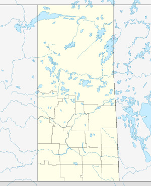 Location of Atwater in Saskatchewan  Atwater, Saskatchewan (Canada) | |
| Coordinates: 50.4631°N 102.1338°W | |
| Country | |
| Province | |
| Region | Southeast |
| Census division | 5 |
| Rural Municipality | Fertile Belt No. 183 |
| Government | |
| • Type | Municipal |
| • Governing Body | Atwater Village Council |
| • Mayor | James Ferguson |
| • Administrator | Sheila Shivak |
| Area | |
| • Land | 1.79 km2 (0.69 sq mi) |
| Population (2016) | |
| • Total | 30 |
| • Density | 16.7/km2 (43/sq mi) |
| Time zone | UTC-6 (CST) |
| Postal code | S0A 0C0 |
| Area code(s) | 306 |
| Highways | |
| Railways | Canadian National Railway |
History
Atwater incorporated as a village on August 12, 1910.[1]
Demographics
In the 2016 Census of Population conducted by Statistics Canada, the Village of Atwater recorded a population of 30 living in 14 of its 16 total private dwellings, a -3.3% change from its 2011 population of 31. With a land area of 1.79 km2 (0.69 sq mi), it had a population density of 16.8/km2 (43.4/sq mi) in 2016.[4]
In the 2011 Census of Population, the Village of Atwater recorded a population of 31, a 24% change from its 2006 population of 25. With a land area of 1.79 km2 (0.69 sq mi), it had a population density of 17.3/km2 (44.9/sq mi) in 2011.[5]
Climate
| Climate data for Atwater | |||||||||||||
|---|---|---|---|---|---|---|---|---|---|---|---|---|---|
| Month | Jan | Feb | Mar | Apr | May | Jun | Jul | Aug | Sep | Oct | Nov | Dec | Year |
| Record high °C (°F) | 7 (45) |
11.5 (52.7) |
21.5 (70.7) |
31 (88) |
38 (100) |
37 (99) |
38.5 (101.3) |
37 (99) |
35 (95) |
33 (91) |
20 (68) |
14 (57) |
38.5 (101.3) |
| Average high °C (°F) | −11.9 (10.6) |
−7.9 (17.8) |
−0.9 (30.4) |
10 (50) |
18.1 (64.6) |
22.3 (72.1) |
24.8 (76.6) |
24.1 (75.4) |
17.8 (64.0) |
10.3 (50.5) |
−1.7 (28.9) |
−9.8 (14.4) |
7.9 (46.2) |
| Daily mean °C (°F) | −17.1 (1.2) |
−12.9 (8.8) |
−6 (21) |
3.8 (38.8) |
11.3 (52.3) |
15.7 (60.3) |
18 (64) |
17 (63) |
11.3 (52.3) |
4.4 (39.9) |
−6.1 (21.0) |
−14.4 (6.1) |
2.1 (35.8) |
| Average low °C (°F) | −22.2 (−8.0) |
−17.9 (−0.2) |
−11 (12) |
−2.4 (27.7) |
4.4 (39.9) |
9.1 (48.4) |
11.2 (52.2) |
9.9 (49.8) |
4.7 (40.5) |
−1.4 (29.5) |
−10.5 (13.1) |
−19 (−2) |
−3.8 (25.2) |
| Record low °C (°F) | −42 (−44) |
−42 (−44) |
−34 (−29) |
−27 (−17) |
−16.5 (2.3) |
−3 (27) |
−0.5 (31.1) |
−3.5 (25.7) |
−8 (18) |
−22 (−8) |
−37 (−35) |
−43 (−45) |
−43 (−45) |
| Average precipitation mm (inches) | 17.7 (0.70) |
12.4 (0.49) |
19.2 (0.76) |
19.3 (0.76) |
53.9 (2.12) |
73 (2.9) |
80.6 (3.17) |
58.7 (2.31) |
49.4 (1.94) |
25.2 (0.99) |
17.2 (0.68) |
18.6 (0.73) |
445.1 (17.52) |
| Source: Environment Canada[6] | |||||||||||||
See also
- List of communities in Saskatchewan
- Villages of Saskatchewan
References
- "Urban Municipality Incorporations". Saskatchewan Ministry of Government Relations. Archived from the original on October 15, 2014. Retrieved June 1, 2020.
- "Saskatchewan Census Population" (PDF). Saskatchewan Bureau of Statistics. Archived from the original (PDF) on September 24, 2015. Retrieved May 31, 2020.
- "Saskatchewan Census Population". Saskatchewan Bureau of Statistics. Retrieved May 31, 2020.
- "Population and dwelling counts, for Canada, provinces and territories, and census subdivisions (municipalities), 2016 and 2011 censuses – 100% data (Saskatchewan)". Statistics Canada. February 8, 2017. Retrieved May 30, 2020.
- "Population and dwelling counts, for Canada, provinces and territories, and census subdivisions (municipalities), 2011 and 2006 censuses (Saskatchewan)". Statistics Canada. June 3, 2019. Retrieved May 30, 2020.
- Environment Canada Canadian Climate Normals 1971–2000, accessed 23 July 2010
Places adjacent to Atwater, Saskatchewan | ||||||||||
|---|---|---|---|---|---|---|---|---|---|---|
| ||||||||||
| Cities |  | ||||
|---|---|---|---|---|---|
| Towns | |||||
| Villages | |||||
| Resort villages | |||||
| Rural municipalities | |||||
| First Nations |
| ||||
| Indian reserves | |||||
| Unincorporated communities |
| ||||