Koumala, Queensland
Koumala is a town and coastal locality in the Mackay Region, north Queensland, Australia.[2][3] Yukan is a neighbourhood in the north of the locality where the Yukan railway station is located (21.5172°S 149.2325°E).[4]
| Koumala Queensland | |||||||||||||||
|---|---|---|---|---|---|---|---|---|---|---|---|---|---|---|---|
 Koumala | |||||||||||||||
| Coordinates | 21°36′22″S 149°14′46″E | ||||||||||||||
| Population | 789 (2011 census)[1] | ||||||||||||||
| Postcode(s) | 4738 | ||||||||||||||
| Location | |||||||||||||||
| LGA(s) | Mackay Region | ||||||||||||||
| Federal Division(s) | Capricornia | ||||||||||||||
| |||||||||||||||
Geography
In the east, Cape Palmerston National Park protects the landscape surrounding Mount Funnel and Cape Palmerston. To the west is the Hatfield Range known locally are the Koumala Range. A gravel road over this range provides alternate access to the Sarina hinterland and was the only route available for several years after the paved route over the Sarina range was destroyed by landslides that occurred during Cyclone Debbie.[5] The main rail line to between the Bowen Basin Coal mines and the port of Hay Point also passes over this range with speed restrictions to 60 km/hr on the downhill section of line[6] because of several derailments which have occurred in this section of track.[7][8]
History
Koumala Post Office opened on 28 February 1884.[9]
The town name Koumala originally derives from the name of its railway station, which was named in 1914 after a sugar property used by Alfred H. Burbank, a sugar grower and surveyor, using a Fijian word indicating sweet potato.[2]
The name Yukan is an Aboriginal word meaning rain.[4]
The town was part of the former Shire of Sarina.
Koumala State School opened in August 1922 and caters for children from Prep to Year six.[10][11] The railway goods shed and associated huts doubled for school purposes from 1922 to 1923 when a proper school house was built, as well as for social functions until a hall came into being.[12]
Yukan State School opened on 1929 and closed circa 1942.[13]
At the 2011 census, Koumala had a population of 789.[1]
Heritage listings
Koumala has a number of heritage-listed sites, including:
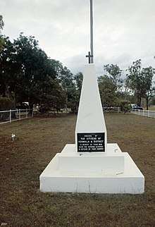
- Mumby Street: Koumala War Memorial[14]
Amenities
The Mackay Regional Council operates a mobile library service on a fortnightly schedule at Bull Street near the school.[15][16]
The Koumala branch of the Queensland Country Women's Association meets at the CWA Hall at 33 Brown Street.[17]
References
- Australian Bureau of Statistics (31 October 2012). "Koumala". 2011 Census QuickStats. Retrieved 11 July 2013.

- "Koumala - town (entry 18520)". Queensland Place Names. Queensland Government. Retrieved 13 September 2015.
- "Koumala - locality (entry 49120)". Queensland Place Names. Queensland Government. Retrieved 24 April 2017.
- "Yukan - railway station in Mackay Region (entry 38772)". Queensland Place Names. Queensland Government. Retrieved 18 January 2020.
- "Cyclone Debbie: Critical road that suffered 'almost biblical' damage reopens after 18 months of work". ABC News. 9 October 2019. Archived from the original on 2 December 2018. Retrieved 19 January 2019.
- "Goonyella System Information Pack, Version 10" (PDF). Aurizon. March 2017. Archived (PDF) from the original on 11 March 2019. Retrieved 19 January 2019.
- "Derailment of Coal Train EG37, Connors Range" (PDF). ATSB. 1 July 2001. Archived (PDF) from the original on 14 February 2014. Retrieved 19 January 2019.
- "Derailment closes coal rail system". 27 December 2010. Archived from the original on 20 January 2019. Retrieved 19 January 2019.
- Premier Postal History. "Post Office List". Premier Postal Auctions. Retrieved 10 May 2014.
- "Opening and closing dates of Queensland Schools". Queensland Government. Retrieved 18 April 2019.
- "Koumala State School". Archived from the original on 4 February 2017. Retrieved 31 January 2017.
- "Koumala". Centre for the Government of Queensland. 2018. Archived from the original on 19 January 2019. Retrieved 19 January 2019.
- Queensland Family History Society (2010), Queensland schools past and present (Version 1.01 ed.), Queensland Family History Society, ISBN 978-1-921171-26-0
- "Koumala War Memorial (entry 601292)". Queensland Heritage Register. Queensland Heritage Council. Retrieved 10 July 2013.
- "Libraries: Contact/Opening Hours". Mackay Regional Council. Archived from the original on 1 March 2016. Retrieved 28 April 2017.
- "Mobile Library Timetable 2017" (PDF). Mackay Regional Council. Archived from the original (PDF) on 1 March 2017. Retrieved 8 May 2017.
- "Branch Locations". Queensland Country Women's Association. Archived from the original on 26 December 2018. Retrieved 26 December 2018.