Kai Kung Leng
Kai Kung Leng (Chinese: 雞公嶺; lit.: 'Cock/Cockscomb Ridge') is a mountain range in Lam Tsuen Country Park, New Territories, Hong Kong.[1]
| Kai Kung Leng | |
|---|---|
| 雞公嶺 | |
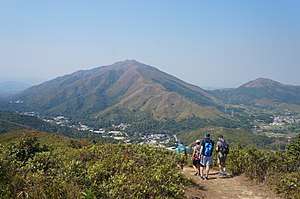 View of Kai Kung Leng, Lam Tsuen Country Park, HK | |
| Highest point | |
| Elevation | 585 m (1,919 ft) Hong Kong Principal Datum |
| Coordinates | 22°27′50.63″N 114°5′7.98″E / 22.4640639°N 114.0855500°E |
| Geography | |
 Kai Kung Leng | |
Geography
There are several peaks on this mountain range.[2] The tallest peak on the Kai Kung Leng mountain range is called Lo Tin Teng and is 585 metres (1,919 ft) above sea level. Nearby, a peak simply called Kai Kung Leng, with the summit-signalling trigonometric post, stands at 572 metres (1,877 ft). Slightly further away to the west, a subpeak called Kai Kung Shan is 374 metres (1,227 ft) tall.
List of selected peaks
- Lo Tin Teng (羅天頂) (585 metres (1,919 ft))
- Kai Kung Leng, as known as Tai Lo Tin (大羅天) or formerly Kwai Kok Shan (572 metres (1,877 ft))
- Lung Tam Shan (龍潭山) (550 metres (1,804 ft))
- Kai Kung Shan (雞公山) (374 metres (1,227 ft))
- Ngau Tam Shan (牛潭山) (337 metres (1,106 ft))
- Kei Lun Shan (麒麟山) (222 metres (728 ft))
Disambiguation
In Hong Kong, there are other similarly-named mountains in different regions of the city, such as Kai Kung Shan (399 m) in Sai Kung West Country Park and another Kai Kung Leng in Kat O (122 m). These locations are all popular hiking spots, so one must plan correctly when visiting.
References
- "WalkOnHill‧Kai Kung Leng". WalkOnHill. Retrieved 2020-03-30.
- "Lam Tsuen". www.afcd.gov.hk. Retrieved 2020-03-30.
| Wikimedia Commons has media related to Kai Kung Leng. |
| 900 meters or more | |
|---|---|
| 800 to 899 meters | |
| 700 to 799 meters | |
| 600 to 699 meters |
|
| 500 to 599 meters |
|
| 400 to 499 meters (excerpt) |
|
| 300 to 399 meters (excerpt) |
|
| 200 to 299 meters (excerpt) |
|
| 100 to 199 meters (excerpt) |
|
| 99 meters or less (excerpt) |
|
| Collectively |
|