Highway M12 (Ukraine)
M12 is a Ukrainian international highway (M-highway) connecting Lviv Oblast to Central Ukraine, where after crossing the Dnieper it continues further as the M04.[1]
| ||||
|---|---|---|---|---|
| Автошлях M12 | ||||
 | ||||
| Route information | ||||
| Part of | ||||
| Length | 746.7 km (464.0 mi) 756.1 km (469.8 mi) with city routes | |||
| Major junctions | ||||
| West end | ||||
| East end | ||||
| Location | ||||
| Regions | Lviv Oblast, Ternopil Oblast, Khmelnytskyi Oblast, Vinnytsia Oblast, Cherkasy Oblast, Kirovohrad Oblast | |||
| Highway system | ||||
Roads in Ukraine
| ||||

General overview
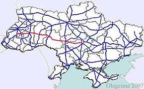
The M12 is a major transnational corridor and along with the M04 combines into E50. The highway is also part of the Gdańsk - Odessa Transportation corridor on the segment from Ternopil to Uman. It is one of the longest routes spanning nearly 800 km (500 mi).
Main Route
Main route and connections to/intersections with other highways in Ukraine.
| Highway M12 | |||
| Marker | Main settlements | Notes | Highway Interchanges |
|---|---|---|---|
| 0 km | Stryi | ||
| Rohatyn | |||
| Ternopil | Bypass | ||
| Khmelnytskyi | Bypass | ||
| Vinnytsia | Bypass | ||
| Uman | |||
| Kropyvnytskyi | |||
| 746 km | Znamianka | ||
Access routes
The highway passes the following cities going around them, however it has spurred away access routes towards them.
- Vinnytsia 1.4 km (0.87 mi)
- Khmelnytskyi 8 km (5.0 mi)
Gallery
 M12 in Vinnytsia oblast
 M12 in Ternopil Oblast
 M12 highway near Ternopil
 M12 junction in Ternopil
External links
- International Roads in Ukraine in Russian
- European Roads in Russian
| E-roads in Ukraine | ||
|---|---|---|
| International | ||
| National | ||
| Regional |
| |
| ||
Roads in Ivano-Frankivsk Oblast | ||
|---|---|---|
| E-roads in Prykarpattia | ||
| International | ||
| National |
| |
| Regional | ||
| ||
This article is issued from Wikipedia. The text is licensed under Creative Commons - Attribution - Sharealike. Additional terms may apply for the media files.