Poltava
Poltava (UK: /pɒlˈtɑːvə/,[2] US: /pəlˈ-/;[3][4] Ukrainian: Полтава [polˈtɑwɐ]; Russian: Полтава [pɐlˈtavə]) is a city located on the Vorskla River in central Ukraine. It is the capital city of the Poltava Oblast (province) and of the surrounding Poltava Raion (district) of the oblast. Poltava is administratively incorporated as a city of oblast significance and does not belong to the raion. It has a population of 289,000.
Poltava Полтава | |
|---|---|
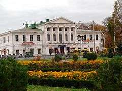
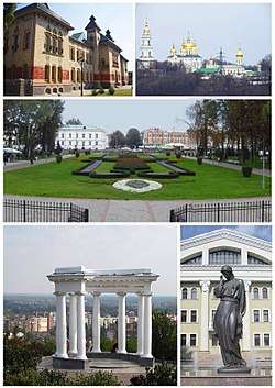 Top left:Poltava Regional Museum, Top right:Poltava Holy Cross Monastery, Center:The Round Square, Bottom left:The White Arbor, Bottom right:Marusia Churai Memorial in Gogolya Street | |
 Flag  Coat of arms | |
 Poltava Location of Poltava in Poltava Oblast.  Poltava Poltava (Ukraine) | |
| Coordinates: 49°35′22″N 34°33′05″E | |
| Country | |
| Oblast | |
| Founded | 8991 |
| Raions | 3 raions (districts)
|
| Government | |
| • Mayor | Oleksandr Mamay (suspended) |
| Area | |
| • Total | 103 km2 (40 sq mi) |
| Population (2018) | |
| • Total | 288,013[1] |
| • Density | 2,811/km2 (7,280/sq mi) |
| Time zone | UTC+2 (EET) |
| • Summer (DST) | UTC+3 (EEST) |
| Postal code | 36000—36499 |
| Area code(s) | +380-532(2) |
| Licence plate | CK, BI |
| Sister cities | Filderstadt, Ostfildern, Veliko Tarnovo, Lublin, Nice |
| Website | rada-poltava |
| 1 The previously believed foundation date was 1174. | |
History
It is still unknown when Poltava was founded, although the town was not attested before 1174. However, for reasons unknown, municipal authorities chose to celebrate the city's 1100th anniversary in 1999. The settlement is indeed an old one, as archeologists unearthed a Paleolithic dwelling as well as Scythian remains within the city limits.
Middle Ages
The present name of the city is traditionally connected to the settlement Ltava which is mentioned in the Hypatian Chronicle in 1174.[5][6] According to the chronicle, on Saint Peter's Day (12 July) of 1182, Igor Sviatoslavich, chasing hordes of the Cuman khans Konchak and Kobiak, crossed the Vorskla River near Ltava and moved towards Pereiaslav), where Igor's army was victorious over the Cumans.[5] During the Mongol invasion of Rus' in 1238–39 many cities of the middle Dnieper region were destroyed, possibly including Ltava.[5]
In the mid 14th century the region was part of the Duchy of Kiev, which was a vassal of the Algirdas' Grand Duchy of Lithuania.[5] According to the Russian historian Aleksandr Shennikov, the region around modern Poltava was a Cuman Duchy belonging to Mansur, who was a son of Mamai.[7] Shennikov also claims that the Mansur Duchy joined the Grand Duchy of Lithuania as an associated state rather than a vassal state, and that the city of Poltava already existed at that time.[7] In 1399 the army of Mansur assisted the army of the Grand Duchy of Lithuania in the battle of the Vorskla River, while a legend says that after the battle, the Cossack Mamay helped Vytautas to escape his death.[7]
The city is mentioned for the first time under the name of Poltava no later than 1430.[5] Supposedly, in 1430 the Lithuanian duke Vytautas gave the city, along with Glinsk (today a village near the city of Romny) and Glinitsa, to Murza Olexa (Loxada Mansurxanovich), who moved to the Grand Duchy of Lithuania from the Golden Horde.[5] In 1430 Murza Olexa was baptized as Alexander Glinsky, who was a progenitor of the Glinsky family.[5] According to Shenninkov, Alexander Glinsky must have been baptized in 1390 by Cyprian, Metropolitan of Kiev, who had just regained his title of Metropolitan of Kiev and all Russia (rather than the Metropolitan of Russia Minor and Lithuania) and on 6 March 1390 permanently moved to Muscovy.[7]
In 1482 Poltava was razed by the Crimean Khan Mengli I Giray.[5]
Early Modern period
In 1537 Ografena Vasylivna Glinska (Baibuza) passed Poltava to her son-in-law Mykhailo Ivanovych Hrybunov-Baibuza.[5]
After the Union of Lublin in 1569, the territory around Poltava became part of the Crown of Poland. In 1630 Poltava was passed to a Polish magnate, Bartholomew Obalkowski.[5] In 1641 it changed ownership again, to Alexander Koniecpolski.[5] In 1646 Poltava became part of Wiśniowiecki Ordynatsia (a large Wiśniowiecki estate in Left-bank Ukraine centered in Lubny), governed by the Ruthenian-Polish magnate Jeremi Wiśniowiecki (1612–51).[5] In 1648 the city became the base of a distinguished regiment of Ukrainian Cossacks, and served as a Cossack stronghold during the Khmelnytsky Uprising.[5] In 1650, to commemorate a victory of the Cossack Host over the Polish army at the Poltavka River, the Metropolitan of Kiev, Sylvester Kossov, ordered the establishment of the monastery of the Exaltation of the Cross in Poltava. The project was financed by a number of prominent local residents, including Martyn Pushkar, Ivan Iskra, Ivan Kramar and many others.[5]
During the 1654 Pereyaslav Council, the Poltava city delegates pledged their allegiance to the Czar of Muscovy, after which stolnik Andrei Spasitelev arrived in Poltava and recorded 1,335 residents who had pledged their allegiance.[5] In 1658 Poltava became a center of anti-government revolt led by Martyn Pushkar, who contested the legitimacy of Ivan Vyhovsky's election to the post of Hetman of Zaporizhian Host.[5] The uprising was extinguished with the help of Crimean Tatars.[5] On the issue boyar Vasily Borisovich Sheremetev wrote to Alexei Mikhailovich on 8 June 1658: "... the Cherkas [Cossack] city of Plotava is ravaged and burned to the ground and only if the Great Sovereign orders to rebuilt on the Tatar Sokma (pathway) of Bakeyev Route and protect many his sovereign cities from Tatar visits. And if the Great Sovereign allows to place a voivode in the city and rebuilt the city until the fall that in Plotava Cherkasy [Cossacks] and residents built their houses and stock-piled their food".[5] With the signing of the 1667 truce of Andrusovo, the city was finally subjected to the Tsardom of Muscovy, while remaining part of the Cossack Hetmanate.
The city suffered from the Great Turkish War when in 1695 Petro Ivanenko led an anti-Muscovite uprising with the help of Crimean Tatars, who ravaged the local monastery.[5] The same year the Poltava Regiment actively participated in the Azov campaigns which resulted in the taking of the Turkish fortress of Kyzy-Kermen (today the city of Beryslav, Kherson Oblast).[5] On 8 July (New Style) or 27 June (Old Style) 1709 the battle of Poltava took place near the city during the Great Northern War. The battle ended in a decisive victory of Peter I of Russia over the Swedish forces and had great historical importance for the Russians.[5] In 1710 there was a plague in the city and its surrounding area.[5] In the mid-18th century the Kolomak Woods near Poltava became a base of haidamaks (Cossack paramilitary bands).[5]
By 1770 Poltava had several brick factories, a regimental doctor, and a pharmacy; that same year the city conducted four fairs.[5] In 1775 it became a city of Novorossiysk Governorate, guarded by the 8th Company of the Dnieper Pike Regiment headquartered in Kobeliaky.[5] In 1775 Poltava's Monastery of the Exaltation of the Cross (Russian: Крестовоздвиженский монастырь, Krestovozdvizhensky Monastyr) became the seat of bishops of the newly created Eparchy (Diocese) of Slaviansk and Kherson. This large new diocese included the lands of the Novorossiya Governorate and the Azov Governorate north of the Black Sea. Since much of that area had only recently been seized from the Ottoman Empire by Russia, and a large number of Orthodox Greek settlers had been invited to settle in the region, the Imperial Government selected a renowned Greek scholar, Eugenios Voulgaris, to preside over the new diocese. After his retirement in 1779, he was replaced by another Greek theologian, Nikephoros Theotokis.[8][9]
In 1779 the city established the Poltava county school, which became its first secular educational institution.[5] In 1787 Catherine the Great stopped in Poltava on the way from Crimea, escorted by Grigori Potemkin, Alexander Suvorov and Mikhail Kutuzov.[5] In Poltava, on 7 June 1787, before another Russo-Turkish War, Potemkin received his title "Prince of Taurida", while Suvorov received a snuffbox with monogram.[5] In 1802 the city became the seat of the newly established Poltava Governorate.[5] The city's population in 1802 consisted of some 8,000 residents.[5] That same year Poltava opened a government-funded hospital of 20 beds.[5]
19th century
On 2 February 1808 the Poltava Male Gymnasium was established.[5] On 20 June 1808 some 54 families of craftsmen were invited to the city from German principalities and settled in the newly established German Sloboda neighborhood with about 50 clay-made houses.[5] In 1810 there were 8,328 people living in Poltava;[5] that same year, the city's first theater was built.[5] In August 1812, on orders of Little Russia Governor General Lobanov-Rostovsky, the famed Ukrainian writer and statesman Ivan Kotlyarevsky formed the 5th Poltava Cavalry Cossack Regiment.[5]
By 1860 Poltava had around 30,000 inhabitants, a district school, a gymnasium, an Institute for Noble Maidens, a spiritual academy, a cadet corps, a library and a number of schools. In 1870 a railway station was opened, leading to rapid economic growth in the region. However, by 1914 the Population of Poltava (around 60,000) was mostly working in small enterprises. In the late 19th and early 20th centuries Poltava became an important cultural centre, where many representatives of Ukrainian national revival were active.
20th century
During the events of 1917–1920, Poltava was under the rule of a number of governments, including the Central Rada, Hetmanate, Ukrainian People's Republic, White Movement and Bolsheviks. After becoming a part of Ukrainian Soviet Socialist Republic, Poltava experienced accelerated industrial growth, and its population increased to 130,000 by 1939.
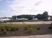
In World War II, the Nazi Wehrmacht occupied Poltava from late October 1941 until 23 September 1943, when it was retaken during the Chernigov-Poltava Strategic Offensive of the battle of the Dnieper. During the Nazi occupation the Jewish population (9.9% of the total population in 1939) was imprisoned in a ghetto before being murdered during mass executions perpetrated by an Einsatzgruppe and buried in mass graves in the area.[10] By the summer of 1944 the United States Army Air Forces conducted a number of shuttle bombing raids against Nazi Germany under the name of Operation Frantic. Poltava Air Base, as well as Myrhorod Air Base, were used as eastern locations for landing B-17 Flying Fortress heavy bombers involved in those operations.
The post-war restoration of Poltava continued in the 1950s and 1960s. The city became an important centre of military education in the Soviet Union, where missile and communications officers were prepared, and was also home to a Soviet Air Force division of heavy bombers.
In 2018, the "Grieving Mother" monument, a memorial in Poltava to 8,000 of the city's Jews murdered by the Nazis, was desecrated on Hitler's birthday with the slogan "Heil Hitler" and a swastika.[11]
Geography
Climate
Poltava has a humid continental climate (Köppen Dfb).
| Climate data for Poltava | |||||||||||||
|---|---|---|---|---|---|---|---|---|---|---|---|---|---|
| Month | Jan | Feb | Mar | Apr | May | Jun | Jul | Aug | Sep | Oct | Nov | Dec | Year |
| Record high °C (°F) | 11.0 (51.8) |
16.0 (60.8) |
21.4 (70.5) |
28.9 (84.0) |
34.2 (93.6) |
39.0 (102.2) |
39.5 (103.1) |
39.4 (102.9) |
35.3 (95.5) |
29.6 (85.3) |
20.0 (68.0) |
14.0 (57.2) |
39.5 (103.1) |
| Average high °C (°F) | −3.1 (26.4) |
−2.0 (28.4) |
3.8 (38.8) |
13.7 (56.7) |
20.8 (69.4) |
24.3 (75.7) |
26.3 (79.3) |
25.7 (78.3) |
19.7 (67.5) |
12.1 (53.8) |
4.2 (39.6) |
−1.1 (30.0) |
12.0 (53.6) |
| Daily mean °C (°F) | −5.5 (22.1) |
−4.8 (23.4) |
0.2 (32.4) |
8.9 (48.0) |
15.3 (59.5) |
18.8 (65.8) |
20.7 (69.3) |
19.9 (67.8) |
14.3 (57.7) |
7.7 (45.9) |
1.4 (34.5) |
−3.3 (26.1) |
7.8 (46.0) |
| Average low °C (°F) | −8.3 (17.1) |
−7.8 (18.0) |
−3.1 (26.4) |
4.2 (39.6) |
9.8 (49.6) |
13.4 (56.1) |
15.4 (59.7) |
14.3 (57.7) |
9.4 (48.9) |
3.7 (38.7) |
−1.3 (29.7) |
−5.8 (21.6) |
3.6 (38.5) |
| Record low °C (°F) | −32.2 (−26.0) |
−29.1 (−20.4) |
−22.8 (−9.0) |
−11.1 (12.0) |
−3.2 (26.2) |
0.9 (33.6) |
7.8 (46.0) |
3.9 (39.0) |
−3.0 (26.6) |
−11.1 (12.0) |
−21.5 (−6.7) |
−28.6 (−19.5) |
−32.2 (−26.0) |
| Average precipitation mm (inches) | 40.7 (1.60) |
39.3 (1.55) |
34.2 (1.35) |
47.7 (1.88) |
52.4 (2.06) |
63.5 (2.50) |
61.1 (2.41) |
51.8 (2.04) |
56.1 (2.21) |
49.5 (1.95) |
44.3 (1.74) |
43.8 (1.72) |
584.4 (23.01) |
| Average precipitation days | 19.2 | 15.7 | 15.7 | 9.0 | 9.6 | 9.2 | 6.9 | 4.7 | 9.3 | 10.8 | 14.4 | 17.9 | 142.4 |
| Average relative humidity (%) | 86.7 | 83.6 | 76.8 | 61.4 | 61.0 | 65.8 | 66.7 | 60.3 | 70.5 | 78.3 | 86.5 | 87.9 | 73.8 |
| Mean monthly sunshine hours | 68.2 | 76.3 | 133.3 | 183.0 | 266.6 | 294.0 | 300.7 | 285.2 | 216.0 | 142.6 | 60.0 | 43.4 | 2,069.3 |
| Source 1: Climatebase.ru[12] | |||||||||||||
| Source 2: Hong Kong Observatory (sun data).[13] | |||||||||||||
Government and subdivisions
Poltava is the administrative center of the Poltava Oblast (province) as well as of the Poltava Raion housed within the city. However, Poltava is a city of oblast subordinance, thus being subject directly to the oblast authorities rather to the raion administration housed in the city itself.
Poltava's government consists of the 50-member Poltava City Council (Ukrainian: Полтавська Міська рада) which is headed by the Secretary (currently Oleksandr Kozub). The city's current mayor is Oleksandr Mamay, who was sworn in on 4 November 2010 after being elected with more than 61 percent of the vote.[14] In 2015 he was re-elected as a candidate of Conscience of Ukraine with 62.9% in a second round of Mayoral election.[15]
The territory of Poltava is divided into 3 administrative raions (districts):[16]
- Shevchenkivsky Raion,[17][18] to the south-west with an area of 2077 hectares and a population of 147,600 in 2005. It's a largely residential area and includes the city centre.
- Kyivsky Raion,[19] is the largest by area, comprising 5437 hectares, or 52.8% of the city total situated in the north and north-west. Its census in 2005 was 111,900. This district has a large industrial zone.
- Podilsky Raion,[20] to the east and south-east, in the valley of the Vorskla river, with an area of 2988 hectares and a population of 53,700 in 2005.
The village of Rozsoshentsi, Scherbani, Tereshky, Kopyly and Suprunivka are officially considered to be outside the city, but actually constitute a part of the Poltava agglomeration.
Culture
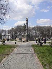
The centre of the old city is a semicircular Neoclassical square with the Tuscan column of cast iron (1805–11), commemorating the centenary of the Battle of Poltava and featuring 18 Swedish cannons captured in that battle. As Peter the Great celebrated his victory in the Saviour church, this 17th-century wooden shrine was carefully preserved to this day. The five-domed city cathedral, dedicated to the Exaltation of the Cross, is a superb monument of Cossack Baroque, built between 1699 and 1709. As a whole, the cathedral presents a unity which even the Neoclassical belltower has failed to mar. Another frothy Baroque church, dedicated to the Dormition of the Theotokos, was destroyed in 1934 and rebuilt in the 1990s.
A minor planet 2983 Poltava discovered in 1981 by Soviet astronomer Nikolai Stepanovich Chernykh is named after the city.[21]
Sports
The most popular sport is football (soccer). Two professional football (soccer) teams are based in the city: Vorskla Poltava in the Ukrainian Premier League and FC Poltava in the Second League. There are 3 stadiums in Poltava: Butovsky Vorskla Stadium (main city stadium), Dynamo Stadium are situated in the city centre and Lokomotiv Stadium which is situated in Podil district. In 2009, we went to the local capital of professional volleyball clubs Poltavchanka, where I can visit Ukraine.
Notable people
- Marie Bashkirtseff – 19th-century Parisian painter, memoirist
- Yitzhak Ben-Zvi – a historian, Labour Zionist leader, and the second and longest serving Israeli president
- Hanka Bielicka – Polish actress
- Oleksandr Bilash – Ukrainian composer
- Andriy Danylko – Ukrainian singer
- Sonia Delaunay – Ukrainian-born French artist, a cofounder of the Orphism art movement, noted for its use of strong colors and geometric shapes
- Nikolai Gogol – writer and playwright
- Alexander Gurwitsch – Russian physician and biologist
- Dmitri Kessel – photojournalist, Life magazine war correspondent 1944–1972
- Vera Kholodnaya – Ukrainian actress, the first star of Russian silent cinema
- Yuri Kondratyuk (born Olexandr Gnatovich Shargei) – astronautics and spaceflight pioneer who, in the early 20th century, foresaw ways of reaching the moon
- Ivan Kotlyarevsky – Ukrainian writer, poet, and playwright
- Anatoliy Vasilievich Lunacharsky – Russian Marxist revolutionary and the first Soviet People's Commissar of Enlightenment responsible for culture and education
- Mykola Lysenko – Composer, founder of first Ukrainian classical music school
- Mstyslav - Ukrainian Orthodox Church hierarch
- Panas Myrny (born Panas Yakovych Rudchenko) – Ukrainian writer (Panas Myrny's Memorial estate)
- Mikhail Vasilievich Ostrogradsky – Ukrainian mathematician, mechanician, and physicist
- Olena Pchilka – Pen name for Olha Petrivna Kosach, mother of Lesya Ukrainka, famous writer, sister of Mykhailo Drahomanov
- Ivan Paskevich – Ukrainian military leader in the Russian service
- Symon Petliura – Ukrainian politician and statesman, a leader of Ukraine's fight for independence following the Russian Revolution of 1917
- Zhanna Prokhorenko – Ukrainian actress
- Sasha Putrya – Ukrainian artist
- Moshe Zvi Segal – a prominent figure in various movements and organizations in Israel, including Etzel and Lechi.
- Avraham Shlonsky – Israeli poet and editor
- Hryhorii Skovoroda – Ukrainian poet, philosopher, and composer
- Maria Tarnowska (born Maria Nikolaevna O'Rourke) – famous femme fatale, whose trial for murder (Venice, 1910) attracted worldwide media attention
- Paisius Velichkovsky – Eastern Orthodox monk and theologian noted for promoting staretsdom
- Nikolai Yaroshenko – Ukrainian painter
- Mikhail Zoshchenko – Soviet satirist
Economy and infrastructure
Transportation
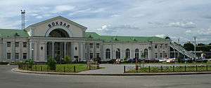
Poltava's transportation infrastructure consists of two major train stations with railway links to Kiev, Kharkiv, and Kremenchuk. Poltava's Kiev line is electrified and is used by the Poltava Express. The electrification of the Poltava-Kharkiv line was completed in August 2008.[22]
The Avtovokzal serves as the city's intercity bus station. Buses for local municipal routes depart from "AC-2" (autostation No. 2 – along Shevchenko street) and "AC-3" (Zinkivska street). Local municipal routes are parked along the Taras Shevchenko Street. Marshrutka minibuses serve areas where regular bus access is unavailable; however, they are privately owned and cost more per ride. In addition, a 10-route trolleybus network of 72.6 kilometres (45.1 mi) runs throughout the city. On the routes of the city go more than 50 units of trolleybuses.
Poltava is also served by an International Airport, situated outside the city limits near the village of Ivashky. The international highway M03, linking Poltava with Kiev and Kharkiv, passes through the southern outskirts of the city. There is also a regional highway P-17 crossing Poltava and linking it with Kremenchuk and Sumy.[23]
Education
Poltava has always been one of the most important science and education centres in Ukraine. Major universities and institutions of higher education include the following:
- Poltava National Pedagogical University named after V. G. Korolenko
- National University "Yuri Kondratyuk Poltava Polytechnic"
- Poltava Agrarian State Academy
- Ukrainian Medical Stomatological Academy as Poltava Medical And Dental University (UMSA)
- Poltava University of Economics and Trade
- Poltava Military Institute of Connections
- Poltava Law Institute of Yaroslav Mudryi National Law University
- Poltava branch of the State Academy of Statistics, region and audit to the State Statistics Committee of Ukraine
Astronomy
- Poltava gravimetric observatory (PGO) is situated a bit north from city centre (27–29 Miasoyedov St.). Its main work directions are measurements of Earth rotation, latitude variations (applying zenith stars observations, lunar occultation observations and other)
- Observational station of PGO in rural area, some 20 km east along the M03-E40 highway. Radiotelescope URAN-2 (Ukrainian: УРАН-2) is situated there too.
International relations
Twin towns – sister cities
Poltava is twinned with:
Gallery
 Building of the Noble Assembly
 State administrative building (Russian Empire)
 Former military hospital
.JPG) Former choral synagogue (today - Regional Philharmonic Society)
Former choral synagogue (today - Regional Philharmonic Society)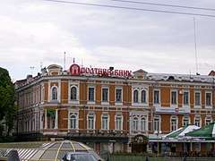 Merchant Ginzburg's "Grand Hotel"
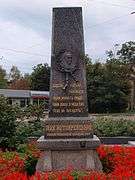 Obelisk at the Ivan Kotlyarevsky's burial
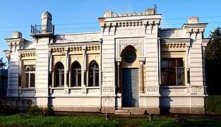 Moorish-styled mansion of Bakhmatsky
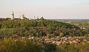 Exaltation of the Cross nunnery
.JPG) Traditional Ukrainian well, krynytsia (Kotlyarevsky's estate)
Traditional Ukrainian well, krynytsia (Kotlyarevsky's estate)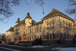 Former Regional Administration building
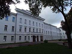 Former Institute of Noble Maidens (today - National Technical University)
%2C.jpg) Mass burial of 1345 Russian soldiers (perished at the Battle of Poltava)
Mass burial of 1345 Russian soldiers (perished at the Battle of Poltava)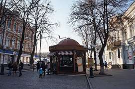 Main pedestrian street of Poltava
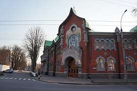 State security office
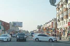 A busy street in central Poltava
References
- Чисельність населення (за оцінкою) на 1 серпня 2018 року / Головне управління статистики у Полтавській області
- "Poltava". Lexico UK Dictionary. Oxford University Press. Retrieved 4 September 2019.
- "Poltava". The American Heritage Dictionary of the English Language (5th ed.). Boston: Houghton Mifflin Harcourt. Retrieved 4 September 2019.
- "Poltava". Merriam-Webster Dictionary. Retrieved 4 September 2019.
- Poltava: chronicles of the most important events. "History of Poltava" website.
- Antipovich, G., Buryak, Voloskov, V., others. Poltava: a book for tourists. Ed.2. "Prapor". Kharkiv, 1989.
- Duchy of the Mamai's descendants. Zarusskiy.org. 29 June 2008
- Евгений Булгарис (Eugenios Voulgaris's biography) (in Russian)
- Никифор Феотоки (Nikephoros Theotoki's biography) (in Russian)
- "The Untold Stories. The Murder Sites of the Jews in the Occupied Territories of the Former USSR". yadvashem.org. Retrieved 18 June 2017.
- "Fury as Ukraine okays new homes on site of Jewish massacre during the Holocaust". Ynetnews. Retrieved 19 June 2019.
- "Climatological Normals for Poltava, Ukraine (1949-2011)". Climatebase. Retrieved 21 April 2013.
- "Climatological Information for Poltava, Ukraine". Hong Kong Observatory. Archived from the original on 26 October 2019. Retrieved 4 September 2012.
- "Oleksandr Mamay won at the elections for the mayor of Poltava" (in Ukrainian). Dzerkalo Tyzhnya. 6 November 2010. Archived from the original on 23 August 2011. Retrieved 14 May 2011.
- Mamai reelected as Poltava mayor – election commission, Interfax-Ukraine (16 November 2015)
- "Poltavska Oblast, city of Poltava (raion councils of the cities)" (in Ukrainian). Verkhovna Rada of Ukraine. Archived from the original on 21 May 2011. Retrieved 4 January 2009.
- "Official resource" (in Ukrainian). Oktiabrskyi Raion Council of Poltava. 2008. Archived from the original on 2 December 2008. Retrieved 3 January 2009.
- "Information of the Oktiabrskyi Raion of Poltava" (in Ukrainian). Poltava City Council. 2007. Archived from the original on 5 April 2009. Retrieved 3 January 2009.
- "Information of the Kyivskyi Raion of Poltava" (in Ukrainian). Poltava City Council. 2007. Archived from the original on 5 April 2009. Retrieved 3 January 2009.
- "Information of the Leninskyi Raion of Poltava" (in Ukrainian). Poltava City Council. 2007. Archived from the original on 5 April 2009. Retrieved 3 January 2009.
- Schmadel, Lutz D. (2003). Dictionary of Minor Planet Names (5th ed.). New York: Springer Verlag. p. 246. ISBN 3-540-00238-3.
- "Poltava-Kharkiv rail line" (in Russian). Retrieved 21 September 2008.
- Poltava – Plan. Kiev Army-Cartographic Fabric.
External links
| Wikimedia Commons has media related to Poltava. |
| Wikivoyage has a travel guide for Poltava. |
- "Official website" (in Ukrainian). Poltava City Council.
- "News" (in Ukrainian). Poltava Oblast State Administration.
- "Poltava Istoricheskaya5" (in Russian). poltavahistory.inf.ua.
- "Main" (in Russian). Transport of Poltava (unofficial project). Archived from the original on 17 December 2008. Retrieved 14 May 2011.
- "Photos of Poltava" (in Russian).
- The murder of the Jews of Poltava during World War II, at Yad Vashem website.
| Raions | |||||
|---|---|---|---|---|---|
| Hromadas | |||||
| Cities |
| ||||
| |||||
| Oblasts | |
|---|---|
| Cities with special status | |
| Autonomous republic | |
| Administrative centers | |
1Claimed and controlled by Russia as the Republic of Crimea and the Federal City of Sevastopol 2Regions are partly controlled by Pro-Russian separatists states of Donetsk People's Republic and Luhansk People's Republic | |
| Authority control |
|
|---|