Highway M06 (Ukraine)
Highway M06 is a Ukrainian international highway (M-highway) connecting Kiev to the Hungarian border near Chop, where it continues as Hungarian main road 4 to Záhony and Budapest.[1]
| |
|---|---|
| Автошлях M06 | |
 | |
| Route information | |
| Part of | |
| Length | 821.5 km (510.5 mi) 846.2 km (525.8 mi) with city routes |
| Major junctions | |
| East end | |
| West end | Hungarian border near Chop |
| Location | |
| Regions | Kiev, Kiev Oblast, Zhytomyr Oblast, Rivne Oblast, Lviv Oblast, Zakarpattia Oblast |
| Highway system | |
| Roads in Ukraine | |
General overview
The M06 is a major transnational corridor and along with the M03 combines into European route E40.[2] The highway is also part of the Pan-European Transportation corridors III and V as well as the "Europe-Asia" Transportation corridor. It is the second longest route spanning over 800 kilometres (500 mi). For most of its length it is categorized as the category Ia highway in Ukraine (see Roads in Ukraine). The M06 connects four major European routes: E40, E50, E85, and E95.
History
The route from Lemberg via Stryj to the then Austro-Hungarian border belonged until 1918 to the Austrian crown land of Galicia and was called the Stryjer Reichsstraße.[3]
Description
From Kiev to Lviv the M06 is part of European route E40, European route E471 from Lviv to Mukacheve, European route E50 from Stryi (Lviv Region) to Uzhhorod, and European route E573 from Uzhhorod to the Hungarian border.
From Kiev to Rivne, the road features 2 lanes in both directions with physical separation, with the exception of Zhytomyr bypass. From Rivne on, the road is mostly a single carriageway, though some dual carriageway sections exist.
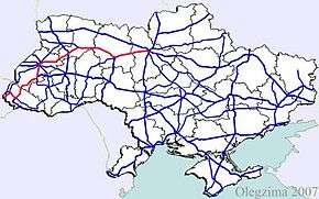
Main route
Main route and connections to/intersections with other highways in Ukraine.
The route starts at the intersection of the Kiev's beltway and Victory Parkway (Prospekt Peremohy), for which it serves as an extension. It used to be known as Brest-Litovsk Highway (Brest-Lytovske Shose).
| Marker | Main settlements | Notes | Highway Interchanges |
|---|---|---|---|
| 0 km | Kiev | ||
| 103 km | Korostyshiv | Bypass 17 km (11 mi) | |
| 128 km | Zhytomyr | Bypass 25 km (16 mi) | |
| 220 km | Novohrad-Volynskyi | Bypass 15 km (9.3 mi) | |
| 258 km | Korets | Bypass 9 km (5.6 mi) | |
| 322 km | Rivne | Bypass 18 km (11 mi) | |
| 374 km | Dubno | ||
| 441 km | Brody | ||
| 530 km | Lviv | Bypass 24 km (15 mi) | |
| 612 km | Stryi | ||
| 651 km | Skole | ||
| 744 km | Svaliava | ||
| 770 km | Mukacheve | ||
| Uzhhorod | |||
| 821 km | Chop / Border (Hungary) |
- Notes
^a). ![]()
![]()
Access routes
The highway passes the following cities going around them, however it has spurred away access routes towards them.
- Zhytomyr 10 km (6.2 mi)
- Novohrad-Volynskyi 5.6 km (3.5 mi)
- Lviv 5.7 km (3.5 mi)
- Rivne 3.4 km (2.1 mi)
Gallery
 M06 Highway in Ukrainian Carpathians
References
- Ukraine International Highways in Russian
- European Highways in Russian
- Kundmachung der k.k. Finanz-Landes-Direktion in Lemberg vom 21. September 1892 Zl. 69.797, betreffend die Vermauthung der Aerarialstraßen in Galizien. LGBl. Nr. 73/1892, p. 181.
External links
- (in Russian) Webpage dedicated to M06
- (in Russian) International Roads in Ukraine
- (in Russian) European Roads
| E-roads in Ukraine | ||
|---|---|---|
| International | ||
| National | ||
| Regional |
| |
| ||