Geography of the Cook Islands
The Cook Islands can be divided into two groups: the Southern Cook Islands and the Northern Cook Islands. The country is located in Oceania, in the South Pacific Ocean, about one-half of the way from Hawaii to New Zealand.
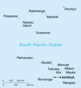
Map of the Cook Islands
Southern Cook Islands
Statistics
- Area
-
- Total: 236 km2 (91 sq mi)
- Land: 236 km2
- Water: 0 km2
- Area - comparative
- 1.3 times the size of Washington, DC
- Coastline
- 120 km (75 mi)
- Maritime claims
-
- Territorial sea: 12 nmi (22.2 km; 13.8 mi)
- Continental shelf: 200 nmi (370.4 km; 230.2 mi) or to the edge of the continental margin
- Exclusive economic zone: 200 nmi (370.4 km; 230.2 mi)
- Climate
- Tropical; moderated by trade winds; a dry season from April to November and a more humid season from December to March
- Terrain
- Low coral atolls in north; volcanic, hilly islands in south
- Elevation extremes
-
- Lowest point: Pacific Ocean 0 m
- Highest point: Te Manga 652 m (2,139 ft)
- Natural resources
- coconuts
- Land use
-
- Arable land: 4.17%
- Permanent crops: 4.17%
- Other: 91.67% (2012 est.)
- Natural hazards
- Typhoons (November to March)
- Environment - international agreements
- Party to: Biodiversity, Climate Change-Kyoto Protocol, Desertification, Hazardous Wastes, Law of the Sea, Ozone Layer Protection
References
![]()
This article is issued from Wikipedia. The text is licensed under Creative Commons - Attribution - Sharealike. Additional terms may apply for the media files.