Pukapuka
Pukapuka, formerly Danger Island, is a coral atoll in the northern group of the Cook Islands in the Pacific Ocean. It is one of most remote islands of the Cook Islands, situated about 1,140 kilometres (708 miles) northwest of Rarotonga. On this small island, an ancient culture and distinct language has been maintained over many centuries. The traditional name for the atoll is Te Ulu-o-Te-Watu ('the head of the stone'), and the northern islet where the people normally reside is affectionately known as Wale ('Home'). The name Pukapuka is also ancient and referred originally to the people.
| Native name: Te Ulu o te Watu | |
|---|---|
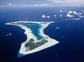 Aerial view of Pukapuka Atoll | |
| Geography | |
| Location | Central-Southern Pacific Ocean |
| Coordinates | 10°53′00″S 165°51′00″W |
| Archipelago | Cook Islands |
| Area | 5 km2 (1.9 sq mi) |
| Administration | |
| Demographics | |
| Population | 425 (2016) |
| Ethnic groups | Polynesian |
Geography
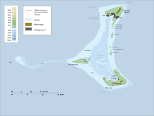
Pukapuka is shaped like a three bladed fan. There are three islets on the roughly triangular reef, with a total land area of approximately 3 square kilometres (1.2 sq mi). Motu Kō, the biggest island is to the southeast; Motu Kotawa (Frigatebird Island) is to the southwest; and the main island Wale is to the north. Kō and Motu Kotawa are uninhabited food reserves, with taro and pulaka gardens and coconut plantations. Pukapuka Airport (ICAO airport code: NCPK) is on Kō.
The three villages are located on the crescent-shaped bay of the northernmost islet of the atoll: Yātō (West), Loto (Central) and Ngake (East). Loto (Roto on most maps) is host to the Island Administration. The traditional names for these villages are Takanumi, Kotipolo and Te Lāngaikula. In daily life, the islanders frequently call them Tiapani (Japan), Malike or Amelika (United States) and Ōlani (Holland) respectively. In sports competitions between the villages, the villagers use the names and flags of these countries.
Although the island has a well-maintained airstrip, flights from Rarotonga are very infrequent. The five-hour flight from Rarotonga via Air Rarotonga now operates when there is a Government charter once every six weeks or so. The island is closer to Samoa than to the rest of the Cook Islands and transport via Samoa is becoming a preferred option for Pukapukans visiting in organised groups (tele parties) from New Zealand and Australia.
The submerged Tima Reef is situated 23 km southeast of Pukapuka. About 60 km away is Nassau (Cook Islands) which is owned by the people of Pukapuka and considered part of it for administrative purposes. Since the 1950s it has been governed by the Council of Chiefs of Pukapuka. The Nassau Island Committee advises the Pukapuka Island Committee on matters relating to its own island.
History
Human settlement of Pukapuka can be dated back about 1,000 years, after the sea level stabilised to its present height.[1]
The atoll served as a connecting hub between West and East Polynesia – a role that is reflected in Pukapukan material culture, and language, which is Samoic with a Tokelauan influence. Pukapukan traditions speak of frequent passages to Tuvalu, Tokelau, Niue, Tonga, Rarotonga and Tahiti, and basalt used for many of their adze blades can be geochemically traced to a quarry on Tutuila (Samoa). Tahitians are known to have passed through Pukapuka en route to islands in Samoa and Tonga.
The original population is likely to have numbered 1000 or more, but has recovered from extremely low numbers more than once. Oral traditions refer to at least two episodes of civil war, and inundation of the atoll from a major tsunami or cyclone, in which only two women and 15 men survived. After numbers recovered again, a raid in 1863 by Peruvian slave traders took 145 men and women, of whom only two returned; and yet in 1866 the estimated population had grown again to 750.[2]
European visitors
Pukapuka was the first of the Cook Islands that Europeans sighted. The Spanish explorer Álvaro de Mendaña saw it on the feast day of Saint Bernard, on Sunday 20 August 1595 and named it San Bernardo.[3]
On 21 June 1765 the British Naval expedition under Commodore John Byron, consisting of HMS Dolphin and HMS Tamar, sighted the island. Byron gave the name "Islands of Danger" because of the reefs and the high surf that made it too dangerous to land. The name "Danger Island" still appears on some maps. According to oral tradition, an unknown ship called at Pukapuka in the mid 18th century, and when the Yalongo lineage chief Tāwaki boldly took the captain's pipe out of his mouth, he was shot. (Tāwaki's grandson, Pania, and great-grandson, Vakaawi, protected the Aitutakian mission teacher, Luka, in 1857).
Thirty years later, Pukapuka was given the name "Isles de la Loutre" (Isles of the Otter) by Pierre François Péron, a French adventurer who was acting as first mate on board the American merchant ship Otter (Captain Ebenezer Dorr) after it was sighted on 3 April 1796. The following day, Péron, Thomas Muir of Huntershill (1765–1799), and a small party landed ashore but the inhabitants would not allow them to inspect the island. Trading later took place near the ship, when adzes, mats and other artifacts were exchanged for knives and European goods.[4]
"Everything united to convince us that we had the right to attribute to ourselves the honour of having discovered three new islands; and with this conviction I gave them the name 'Isles of the Otter' ('Isles de la Loutre') which was the name of our vessel. In order to distinguish them, we named the eastern one 'Peron and Muir' [Motu Kō], the one to the north 'Dorr' [Pukapuka], and the name of 'Brown' was given to the third [Motu Kotawa], after one of our officers."[4] Péron believed that they were the first to discover the island, mostly because the people were so afraid of them. The Pukapukans' fear of the visitors was because Tāwaki had been killed during the ship visit about 30 years previously.
Because of Pukapuka's isolation, few vessels visited before 1857 when the London Missionary Society landed teachers from Aitutaki and Rarotonga. Luka Manuae of Aitutaki later wrote an extended account of the first days of contact 5–8 December 1857: "No te taeanga o te tuatua a te Atua ki Pukapuka" ('The arrival of the Word of God at Pukapuka', dated August 1869).[5] Some lineages wanted to kill the newcomers in revenge for an incident that had happened a month earlier, but Vakaawi, chief of Yālongo lineage, protected them. In the following days, the island accepted Luka's Christian message, largely because of an encounter when two dead people were apparently raised back to life.
In 1862 Rev. William Wyatt Gill found most of the people on the island converted to Christianity. Early in 1863 Peruvian slavers raided the island and took away a total of 145 men and women; only two returned, Kolia and Pilato (Malowutia). The London Missionary Society barque John Williams was wrecked on the western side in May 1864.[6] In 1868 the buccaneer Bully Hayes took about 40 people to go on a labour scheme, but none of them returned home.
Pukapuka was proclaimed a British protectorate in 1892 and was included in the Cook Islands boundaries under the control of New Zealand in 1901.
World War II
Three U.S. Navy fliers from the USS Enterprise arrived on Pukapuka in February 1942.[7] Harold Dixon, Gene Aldrich, and Tony Pastula survived 34 days on the open ocean in a tiny 4 by 8 foot (1.2 by 2.4 m) raft, beginning their odyssey with no food or water stores and very few tools. They were found by Teleuka Iotua huddled in a hut belonging to Lakulaku Tutala on Loto Village's reserve, where he gave them coconuts to drink. He then went and got more help. Shortly after their arrival a cyclone struck the island and caused widespread damage. Their story was told in the book The Raft by Robert Trumbull, published by Henry Holt and Co. in 1942, and released as a motion picture Against the Sun[8] in 2014.
Post World War II
Pukapuka was hit by Cyclone Percy in February 2005 — a Category Five cyclone that destroyed the taro gardens, brought down thousands of trees, and damaged three-quarters of the houses.
Treaty
From 1856 to 1980, the United States claimed sovereignty over the island under the Guano Islands Act. On 11 June 1980, in connection with establishing the maritime boundary between the Cook Islands and American Samoa, the United States signed Cook Islands – United States Maritime Boundary Treaty acknowledging that Pukapuka was under Cook Islands sovereignty.[9][10]
Culture
Pukapuka has its own language and customs that are different from those of the rest of the Cook Islands.
The entire population is said to be descended from seventeen men, two women and an unknown number of children who survived a catastrophic storm and tsunami in the 17th century.[11] The description of the tragedy, complete with thunder and lightning, is more in keeping with a severe cyclone, and the huge waves it generated swept most of the people away. A new estimate of the date of the calamity based on genealogical records suggests that it happened about 1700.
The island had a population of 664 at the 2001 census, but since 2005 the population has declined to less than 500.
The American writer Robert Dean Frisbie settled on Pukapuka in 1924 and wrote books about it. He said at the time he was looking for a place beyond the reach of "the faintest echo from the noisy clamour of the civilised world".
References
- Chikamori, Masashi (1996). "Development of coral reefs and human settlement: Archaeological research in the Northern Cook Islands and Rarotonga". Bulletin Indo-Pacific Prehistory Assn. 15: 45–52.
- Crowe, Andrew (2018). Pathway of the Birds: The Voyaging Achievements of Māori and their Polynesian Ancestors. Auckland: David Bateman Ltd. pp. 134–5.
- Sharp, Andrew, The discovery of the Pacific Islands, Oxford 1960 p.52,53
- Pierre François PÉRON (1824). Mémoires du Capitaine Péron, sur ses Voyages aux Côtes d’Afrique, en Arabie, a l’Île d’Amsterdam, aux Îles d’Anjouan et de Mayotte, aux Côtes Nord-Oeust del’Amérique, aux Îles Sandwich, a la Chine, etc. Libraire, Bossange Frères. Paris: Brissot-Thivars. Retrieved 31 July 2010.
- Luka Manuae, (2012) "The arrival of the word of God at Pukapuka", Journal of Pacific History, Dec.
- Beaglehole, Earnest and Pearl (1938). "Ethnology of Pukapuka," Bernice P. Bishop Museum Bulletin, 150.
- "Where are they now?" Newsweek Magazine. 8 February 1954.
- "Against the Sun". 23 January 2015. Retrieved 2 May 2017 – via IMDb.
- Dod, Karl C. (1987). The Corps Of Engineers: The War Against Japan. United States Army In World War II. Washington, DC: Center Of Military History, United States Army. pp. 169, 171, 233. LCCN 66060004.CS1 maint: ref=harv (link)
- Office of The Geographer, Bureau of Intelligence and Research (2013). "Limits In The Seas No. 100; Maritime Boundaries: United States—Cook Islands and United States—New Zealand (Tokelau)" (PDF). Retrieved 29 August 2013.
- Beaglehole and Beaglehole (1938).
External links
| Wikimedia Commons has media related to Pukapuka. |