Dorking
Dorking /ˈdɔːr.kɪŋ/ is a market town in Surrey, south east England, 21 miles (34 km) south of London.[3] The main axis of the town runs east-west along the northern face of an outcrop of Lower Greensand and parallel to the course of the Pipp Brook. The town is between Ranmore Common on the North Downs and Leith Hill in the Greensand Ridge.
| Dorking | |
|---|---|
| Market town | |
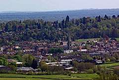 Dorking from Denbies hillside, Ranmore Common | |
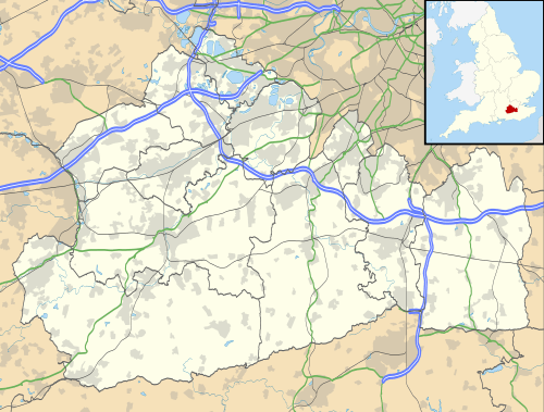 Dorking Location within Surrey | |
| Area | 6.57 km2 (2.54 sq mi) |
| Population | 11,185 (2011 census)[1] or 17,098 (its Built-up Area) [2] |
| • Density | 1,702/km2 (4,410/sq mi) |
| OS grid reference | TQ165496 |
| • London | 21 mi (34 km) NNE |
| Civil parish |
|
| District | |
| Shire county | |
| Region | |
| Country | England |
| Sovereign state | United Kingdom |
| Post town | Dorking |
| Postcode district | RH4 |
| Dialling code | 01306 |
| Police | Surrey |
| Fire | Surrey |
| Ambulance | South East Coast |
| UK Parliament | |
In the Georgian and Victorian periods six prominent sites in the former parish or on its boundaries became grand country estates: Leith Hill Place, Denbies (today a vineyard/hotel), Norbury Park, Polesden Lacey, Wotton House and Deepdene; five of which along with nearby Box Hill's promontory and chalk grassland slopes belong to the National Trust. Dorking is a commuter and retirement settlement with three railway stations and a few large offices of multinational companies. Similarly, Malden in 1911, noted the place was "almost entirely residential and agricultural, with some lime works on the chalk, though not so extensive as those in neighbouring parishes, a little brick-making, water-mills (corn) at Pixham Mill, and timber and saw-mills". Fine sand often in veins of pink colour, used for mortar and in glassmaking was dug, particularly in the 19th century — the Dorking Caves were accordingly excavated under southern parts of the town centre itself.
Dorking chickens with short five-toed legs are a major local breed. The town has a local government headquarters and hosts repeating loops of the FIA-ranked London-Surrey cycle classic elite category event every year.
Toponymy
The origins and meaning of the place-name are uncertain, and a subject of scholarly debate.[4] Early spellings include Dorchinges (1086), Doreking' (1138–47), Dorkingg (1219), and other variants.[5] Both principal elements in the name are disputed. The first element may be from a personal name, Deorc, or some variant, which might arguably be of either Brittonic or Old English origin; but it might equally be from a Brittonic word Dorce, a river-name meaning "clear, bright stream"; or possibly from a British word duro, meaning a "fort", "walled town" or "gated place". The second element, if originally plural (–ingas), might mean "(settlement belonging to the) followers of ...", but if singular (–ing) might mean "place", "stream", "wood" or "clump". The issue remains complex and unresolved.
History and development
Dorking began to become more than an agricultural village as a small staging post on Stane Street, the Roman road between London and Chichester on the English Channel.
Dorking appears in Domesday Book of 1086 as the Manor of Dorchinges. It was held by William the Conqueror. Its Domesday assets were: one church, three mills worth 15s 4d, 16 ploughs, 3 acres (1.2 ha) of meadow, woodland and herbage for 88 hogs. It rendered £18 per year to its feudal system overlords.[6]
Subsequent Lords of the Manor included the Dukes of Norfolk, who lived in Dorking until they moved to Arundel. One of them is buried in Dorking churchyard. In the medieval period, Dorking was a prosperous agricultural and market town with businesses, including milling and brewing, capitalising on its position on the junction of a number of long distance roads and local tracks.
In 1750, the construction of a turnpike road made Dorking a staging post on the route to Brighton and the coast. The Bull's Head in South Street had a famous coachman, William Broad, whose portrait hangs in Dorking Museum in West Street. An inn in the centre of Dorking, the White Horse, was developed in the 18th century; previous buildings on this site belonged to the Knights Templar and later the Knights of St John.
Dorking held a big wheat and cattle market in the High Street. The poultry market was held in the corner of South Street and round Butter Hill. Here the famous Dorking fowl were sold. This breed, which has five claws instead of the normal four, was a favourite for 19th century tables, including that of Queen Victoria.
Dorking lost its stagecoaches when the railways arrived, but then attracted wealthy residents who built large houses in and around the town, such as Denbies House and Pippbrook House (now with council offices in the grounds). Surrounding land and beauty spots such as Cotmandene[7] and Box Hill were donated by landowners for public use, protected by the Metropolitan Green Belt and the AONB designation of the North Downs and Greensand Ridge.
Cotmandene is a 4.78 ha (12-acre) area of common land to the east of the town centre, (the name is thought to mean the heath of the poor cottages).[8][9] Cricket matches were played on the heath during the 18th century and are recorded in Edward Beavan's 1777 poem Box Hill.[10] A painting entitled A Cricket Match on Cotmandene, Dorking by the artist James Canter, dating to around 1770, is now held by the Marylebone Cricket Club.[11]
A game resembling rugby was once played here. The two sides were unlimited in number, representing the east and west of the town. The goals were the two bridges on the Pipp Brook. The Town Crier kicked off the ball at 2 pm and stopped play at 6 pm. The game was started at the church gates and was "rioted" up and down the High Street. It ceased in 1897 after complaints by tradesmen and it was officially stopped under section 72 of the Highway Act 1835.
In the 1880s there was a proposal to supply seawater to the town from a conduit between Lancing and London.[12]
Dorking was an urban district from 1894 to 1974. In 1911 it was described in the Victoria County History, compiled for the county that year and the next, as "almost entirely residential and agricultural, with some lime works on the chalk, though not so extensive as those in neighbouring parishes, a little brick-making, water-mills (corn) at Pixham Mill, and timber and saw-mills."[13]
Geography
The town is in the west of the area between hill ranges in southern England known as Holmesdale which has headwaters of several rivers. The town's geography is undulating; for example, the elevation of the southern point of the central one-way system is 76 metres (249 ft) and on its northern side the elevation is 59–60 metres (194–197 ft). The Mole's nearest point to the town lies at 45 metres (148 ft).[3]
Just northeast of the town the River Mole cuts a steep-sided valley through the North Downs. On the west bank is Denbies Vineyard, the largest vineyard in the UK.[14] On the east bank is Box Hill, owned by the National Trust and Britain's first Country Park. The hill has been designated a Site of Special Scientific Interest, because of the large number of rare orchids which grow there in the summer.
Further north is Norbury Park, which contains the Druids Grove, a forest of ancient yew trees.
To the south west of the town is Leith Hill, also owned by the National Trust, the second highest point in the south east of England after Walbury Hill. The tower on the summit elevates the hill to 1,000 ft (300 m) above sea level. The area is towards the east of the Surrey Hills AONB surrounded by the Greensand Ridge, including Holmbury Hill and Pitch Hill, as well as the nearby escarpment of the North Downs from Box Hill to Newlands Corner.
A species of fish-eating dinosaur, Baryonyx walkeri, was discovered in clay pits just south of Dorking. The creature had a long curved claw on each hand and remains of its last meal were discovered fossilised in its ribcage.[15] The skeleton can be seen at the Natural History Museum in London. One disused clay pit (Inholms lane) is now open to the public as a nature reserve.
Neighbouring areas of Surrey | |
|---|---|
Climate
Dorking experiences an oceanic climate (Köppen climate classification Cfb) similar to almost all of the United Kingdom.
Amenities and landmarks
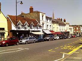
Much of the original character survives, whilst accommodating businesses that serve the needs of the 21st century. The town is well known for its antique dealers. The town's three main trading streets of High Street, West Street and South Street are complemented by a small open-air shopping centre, St Martin's Walk, which is adjacent to the town's main car park and easily accessed from the High Street.[16]
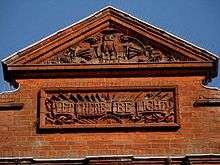
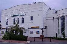
In the late 1990s Dorking Halls was given a huge refit, to make it a cinema and theatre complex. In 2003 a new modern leisure centre and swimming pool were added to the Dorking Halls Complex.
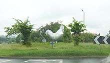
There is a thin, somewhat shiny metal statue of a Dorking cockerel on the Deepdene roundabout.[17]
Dorking and nearby Box Hill were chosen as part of the route for the 2012 London Olympics cycling road race and have featured in the FIA-ranked London-Surrey cycle classic and the Prudential RideLondon-Surrey 100 mass participation sportive[18] every year since. A cycling statue was unveiled in July 2012 at the Pixham End roundabout on the A24 to commemorate the Olympic race passing through Dorking.[19]
In the mid-1960s the Goodwyns council estate was built at the south end of the town, adjacent to North Holmwood. The design of the terraced houses, three- and four-storey flats and twin eleven-storey tower blocks was praised by architectural historians Ian Nairn and Nikolaus Pevsner.[20]
The Deepdene Trail, a heritage walking trail, opened in 2016.[21]
Governance
Surrey County Council elected every four years, has three representatives, with only a few close but outlying farms falling under the latter two wards :
| First Elected | Member[22] |
Ward | |
|---|---|---|---|
| 2005 | Stephen Cooksey | Dorking and the Holmwoods – includes the town Dorking | |
| 2001 | Helen Clack | Dorking Rural – comprises farms and villages east of Dorking | |
| 1993 | Hazel Watson | Dorking Hills – comprises farms and villages south & west of Dorking | |
Five councillors sit on Mole Valley borough council, who are:
| Election | Member[23][24] |
Ward | |
|---|---|---|---|
| 2008 | Paul Elderton | Dorking North | |
| 2016 | David Draper | Dorking North | |
| 2011 | Stephen Cooksey | Dorking South | |
| 2010 | Margaret Cooksey | Dorking South | |
| 2012 | Tim Loretto | Dorking South | |
Famous residents
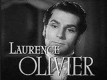
- People born in the town include: Laurence Olivier, Lord Olivier, in 1907 – a blue plaque marking his birthplace can be found in Wathen Road.
- Other people born in Dorking include Walter Dendy Sadler (1854–1923) artist and painter, and Oxford United F.C. Striker Jamie Mackie (born 1985).
- General Sir Lewis Halliday, a Victoria Cross recipient, died in Dorking.
People who have lived in the town in the past include:
- Daniel Defoe (c.1660-1731), who attended Rev. James Fisher's boarding school in Pixham Lane, and later mentioned Dorking in his Tour thro' the whole island of Great Britain.[25]
- Henry Hope and his nephew Thomas Hope spent summers at Deepdene on the outskirts of the town at the beginning of the 19th century. Benjamin Disraeli wrote his novel Coningsby while staying at Deepdene House (demolished 1967).
- Peter Labilliere, a former Army Major and political agitator lived in a cottage on Butter Hill from 1789.[26] In accordance with his wishes he was buried head downwards 11 June 1800 on the western side of Box Hill.[27]
- The Cubitt family had links with the town. Thomas Cubitt was born and lived in the town, and later built up large areas of London from the early 19th century. His politician son George also had connections with the town, and notably financed the building of St Barnabas Church on Ranmore Hill, known by its nickname of Cubitt's Spire, Cubitt's Finger or Cubitt's Stump.[28]
- The English writer George Meredith and the Polish poet Marian Hemar are buried at the local cemetery.
- The composer Ralph Vaughan Williams lived in Dorking for much of his life, and penned in Dorking most of the works which made him famous. The lark in "The Lark Ascending" is known to have been heard in the Mole Valley to the north of the town.
- Composer David Moule-Evans (1905-1988) married Monica Warden Evans in March 1935[29] and the couple lived at Claremont, 10 Rose Hill.[30] He collaborated with Vaughan Williams on the pageant play England's Pleasant Land, written by E.M. Forster and first staged in Dorking in 1938.[31]
- Kenneth Baker served as Member of Parliament for Mole Valley from 1983 to 1997 and lived for most of that time in Betchworth. On retirement he was made a life peer and took the title 'Kenneth Baker, Baron Baker of Dorking'.
- Graham Gouldman and Eric Stewart of the band 10cc opened a studio, Strawberry Studios South, in a former cinema at the end of South Street in 1976, following the departure of Kevin Godley and Lol Creme. Songs recorded here include "The Things We Do for Love" and "Good Morning Judge". Songs recorded here by other artists include "Ebony and Ivory" by Paul McCartney and Stevie Wonder. The building was later demolished and the site was used as a builders yard for a time; a housing development now occupies the site. In addition, The Cure recorded and mixed at Rhino Studios, which was at Pippbrook Mill, Fairfield Drive.
- Actor Leslie Howard lived in a 16th-century farmhouse called Stowe Maries on the edge of Westcott, Surrey, just outside Dorking.
- Absolute Radio DJ Christian O'Connell lived in Dorking with his wife and two children for several years until 2018.
Local government
Dorking is the administrative centre of Mole Valley District Council. It is in the Mole Valley parliamentary constituency.
Transport
Dorking is at the junction of the A24 (London to Worthing) and A25 (Maidstone to Guildford) roads.
The town has three railway stations:
- Dorking railway station, on the (north/south) Epsom to Horsham Sutton & Mole Valley Line. Services are run by Southern to London Victoria via Sutton. South Western Railway run services to London Waterloo.
- Dorking Deepdene, on the (west/east) Guildford to Redhill North Downs Line. Services are run by Great Western Railway.
The above two stations are a short walk from one another, north of the town.
- Dorking West, also on the Guildford to Redhill North Downs Line, but with fewer trains stopping.
Most bus services are run by Arriva, the main locations served being Guildford, Redhill and Reigate and villages in between, as well as some local services. Sunray Travel operates a Surrey CC supported route to Leatherhead and Epsom, and running via Box Hill. Metrobus took over Arriva's Horsham depot, and now run route 93 to Horsham, and London Buses route 465 to Kingston.
Education
Various primary schools cater for 5–11-year olds. Secondary education in the state sector is largely provided for by The Ashcombe School and The Priory School.
The oldest primary school in Dorking is Powell-Corderoy Primary School. The school celebrated its 200th anniversary on 1 July 2016, having been founded (as Dorking British School) in 1816.[33]
Leisure and culture

On 15 June 2004, Dorking was granted Fairtrade Town status.
The Dorking Halls is a cinema, theatre, leisure centre and swimming pool complex. There is also an "Arts Alive" Festival which takes place annually during the last two weeks of October. Dorking Halls is also yearly host to a professional pantomime which was re-introduced in December 2006, after several years of hosting Zippo's Circus.
Dorking also has a museum, a library, about twenty pubs and a CIU-affiliated club. It is noted for its antique and art shops on West Street.
The town formerly had two Non-League football clubs. Dorking Football Club, who played in the National Feeders leagues, Isthmian league for 45+ years and were based in the centre of the town at the Meadowbank but went into liquidation in 2017. Dorking Wanderers play in the National League South (Level 6) after 11 promotions in its 20 years of existence at the Dorking Wanderers Stadium, near Westhumble. From November 2017 they moved into a £6 million ground built on the site of Meadowbank.
Dorking rugby football club, which plays at Brockham, won the Powergen Vase in 2005/2006; and subsequently won promotion from National League 3 (London & South East) to National League 2 South and Surrey Cup double in 2014.[34][35] Dorking and Mole Valley Athletics Club is based at Pixham Sports Ground. They host the annual Dorking Ten road race starting from Brockham Green.[36] Dorking also has a cycling club that meets on Sunday mornings at the Sports Centre in Reigate Road, offering group rides for all abilities and cycling interests. Peter King, former Chief Executive of British Cycling, is the Honorary President of Dorking Cycling Club. The Mole Valley Bowmen meet in the grounds of St Martin's primary school.[37]
Near Dorking lies the Leith Hill escarpment of the Greensand Ridge, including the hills of Holmbury Hill and Pitch Hill, as well as the nearby escarpment of the North Downs from Box Hill to Newlands Corner. Both ridges are notable in southern England for country walks, rambling and mountain biking, and the town in one of the narrowest gaps between high parts of them has a number of premises catering to these pursuits. Part of the Vale of Holmesdale, much of the post town but not town itself is within the Surrey Hills AONB. Adjacent to Dorking is Denbies Wine Estate. The Dorking Group of Artists, established in 1947, exhibit locally twice a year, in Betchworth and at Denbies.[38]
Under part of the town centre are the Dorking Caves which were dug for sand, mostly in the 19th century, and are open occasionally to the public.
Leith Hill Musical Festival
Each year in April, the town plays host to the Leith Hill Musical Festival for local choral societies. This was founded in 1905 by Margaret Vaughan Williams, sister of the composer Ralph Vaughan Williams, and Lady (Evangeline) Farrer, wife of Lord Farrer of Abinger Hall.[39] Ralph Vaughan Williams was the Festival Conductor from 1905 to 1953. The present Festival Conductor is Brian Kay.[40]
The festival is competitive lasting three days, each day with a different division of choirs; each evening the choirs who have competed during the day combine to give a concert of the works which form the subject of the competitions. Following the tradition established by Vaughan Williams, the St. Matthew Passion or the St. John Passion of J. S. Bach are also frequently performed by the combined choral societies.
After the death of Vaughan Williams in 1958 the festival committee commissioned, from David McFall A.R.A., two identical bronze plaques with a likeness of the composer: one was placed in St. Martin's church and one in the Dorking Halls. In 2001 a smaller than life-size bronze statue of Vaughan Williams by William Fawke was erected outside the Dorking Halls.
Cultural references
The Battle of Dorking, a novella written by Lt. Col. Sir George Tomkyns Chesney in 1871, was set in the town. Describing a fictional invasion and conquest of Britain by a German-speaking country, it triggered an explosion of what came to be known as invasion literature.
Demography and housing
In groupings by such bodies as Surrey County Council, the unparished area in terms of civil parishes in England, North Holmwood is grouped with Dorking, and is subsidiary to the town as lacking many amenities and services. However, as with Westcott, neighbouring settlements with their own church and a degree of physical divide (a hill and fields respectively) are considered separately.
| Ward | Detached | Semi-detached | Terraced | Flats and apartments | Caravans/temporary/mobile homes/houseboats | Shared between households |
|---|---|---|---|---|---|---|
| Dorking North | 378 | 548 | 451 | 465 | 0 | 0 |
| Dorking South | 865 | 695 | 417 | 1,045 | 0 | 3 |
| Ward | Population | Households | % Owned outright | % Owned with a loan | hectares |
|---|---|---|---|---|---|
| Dorking North | 4,157 | 1,842 | 34 | 38 | 255 |
| Dorking South | 7,001 | 3,025 | 34 | 32 | 402 |
| Regional average | 35.1 | 32.5 |
References
- Key Statistics; Quick Statistics: Population Density United Kingdom Census 2011 Office for National Statistics Retrieved 20 December 2013
- "Custom report - Nomis - Official Labour Market Statistics". www.nomisweb.co.uk.
- "UK Grid Reference Finder". UK Grid Reference Finder. Retrieved 29 April 2012.
- Briggs, Rob (2018). "Dorking, Surrey". Journal of the English Place-Name Society. 50: 17–54.
- Briggs 2018, p. 19.
- Surrey Domesday Book Archived 30 October 2007 at the Wayback Machine
- "List of Recreation Areas and Parks". Mole Valley Borough Council. February 2007.
- "The Cotmandene, Chart Lane, Dorking". Retrieved 7 August 2013.
- Timms, John (1822). A Picturesque Promenade Round Dorking, in Surrey. London: John Warren. p. 96.
- Beavan, E (1777). Box Hill, a descriptive poem. London: Wilkie.
- "Howzat". Dorking Museum and Heritage Centre. Retrieved 7 August 2013.
- ".SEA.-WATER SUPPLY.|1880-12-11|The Cardigan Observer and General Advertiser for the Counties of Cardigan Carmarthen and Pembroke - Welsh Newspapers". newspapers.library.wales.
- H.E. Malden, ed. (1911). "Parishes: Dorking". A History of the County of Surrey: Volume 3. Institute of Historical Research. Retrieved 27 December 2013.
- "Denbies Wine Estate - Vineyard in Dorking, Mole Valley - Visit Surrey". www.visitsurrey.com.
- "News archive, Natural History Museum website".
- "Description of Dorking from Local Authority". Mole Valley Borough Council. February 2007.
- Guy Martin (28 May 2012). "Dorking cockerel gets in Diamond Jubilee spirit". Get Surrey. Retrieved 26 June 2012.
- "Prudential RideLondon-Surrey 100". www.prudentialridelondon.co.uk. Retrieved 25 November 2018.
- "Geograph:: Pixham End Roundabout cycling statue [7 photos] in TQ170508". www.geograph.org.uk. Retrieved 25 November 2018.
- Nairn & Pevsner 1971, p. 198.
- "The Deepdene Trail". Mole Valley District Council. Retrieved 11 August 2016.
- Surrey County Councillors. Retrieved 24 December 2016
- Mole Valley Councillors. Retrieved 5 June 2012
- "Mole Valley Results 2009–11" (PDF).
- "Daniel Defoe Biography | List of Works, Study Guides & Essays | GradeSaver". www.gradesaver.com.
- Lander, J (2000). Peter Labilliere: The Man Buried Upside Down on Box Hill. Chertsey: Post Press. ISBN 978-0-9532424-1-2.
- Timbs, J (1877). English Eccentrics and Eccentricities. 1. London: Chatto and Windus.
- "StackPath". www.cofeguildford.org.uk. Archived from the original on 17 July 2011.
- The Times, 8 March 1935, p 19
- "WHO'S WHO & WHO WAS WHO". www.ukwhoswho.com.
- Frogley, Alain and Thomson, Aidan J (eds). The Cambridge Companion to Vaughan Williams (2013), p 177. ISBN 9780521162906
- Surrey Advertiser twinning info
- "Powell Corderoy History". Retrieved 14 July 2016.
- "Host Site - Welcome to First Sports Websites". www.dorkingrfc.co.uk.
- 2005/2006 Powergen Vase Archived 8 November 2006 at the Wayback Machine
- Dorking and Mole Valley Athletics Club
- "Mole Valley Bowmen".
- "Dorking Artists". dga1.
- And Choirs Singing, An account of the Leith Hill Musical Festival 1905–1985
- "Leith Hill Music Festival". Retrieved 14 November 2010.
Bibliography
- Nairn, Ian; Pevsner, Nikolaus (1971) [1962]. The Buildings of England: Surrey (2nd ed.). Harmondsworth: Penguin Books. ISBN 0-300-09675-5.CS1 maint: ref=harv (link)
External links
| Wikimedia Commons has media related to Dorking. |
- Mole Valley District Council
- Dorking at Curlie
- Surrey County Council. "Dorking". Exploring Surrey's Past. Retrieved 30 December 2017.
|
|  | ||||||||||||||||
|---|---|---|---|---|---|---|---|---|---|---|---|---|---|---|---|---|---|---|
| Parks | ||||||||||||||||||
| Places of worship |
| |||||||||||||||||
| Education | ||||||||||||||||||
| Transport |
| |||||||||||||||||
Buildings and structures | ||||||||||||||||||
| Sport |
| |||||||||||||||||
Places listed are articles notable as settlements, arranged by post town The two principal towns are emboldened | ||||||||||||||||||
| Authority control |
|
|---|