Leith Hill
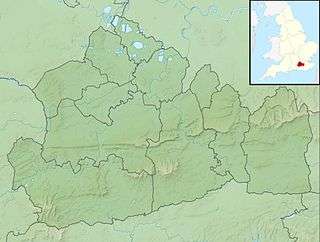
Leith Hill is the highest summit of the Greensand Ridge,[2] approximately 6.7 km (4 mi) south west of Dorking, Surrey and 40.5 km (30 mi) south west of central London. It reaches 294 m (965 ft) above sea level,[3] and is the second highest point in south-east England, after Walbury Hill in south west Berkshire, (which is 297 m (974 ft) high).[1] Leith Hill is the highest ground for 79 km (49 mi).
| Leith Hill | |
|---|---|
 | |
| Highest point | |
| Elevation | 294 m (965 ft) |
| Prominence | 249 m (817 ft) |
| Listing | Marilyn,[1] Hardy, County Top |
| Coordinates | 51°10′33″N 0°22′11″W |
| Geography | |
 Leith Hill Leith Hill in Surrey | |
| Location | Surrey, England |
| Parent range | Greensand Ridge |
| OS grid | TQ139431 |
| Topo map | OS Landranger 187 |
Four areas of woodland surrounding the hill comprise the 337.9-hectare (835-acre) Leith Hill Site of Special Scientific Interest, although the summit is excluded from this designation.[4]
The nearest railway station is Holmwood station, 3.6 km (2 mi) to the east, served by Southern trains to London Victoria.
Leith Hill Tower
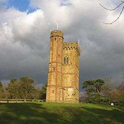
On the summit of Leith Hill is an 18th-century Gothic tower. In 1764–65 Richard Hull of nearby Leith Hill Place built "Prospect House", later to become known as Leith Hill Tower,[5] with the intention of raising the hill above 1,000 ft (305 m) above sea level. A tower built contemporaneously at the summit of Bredon Hill achieves a similar purpose. Leith Hill Tower is 19.5 metres (64 ft) high and consisted of two rooms "neatly furnished", with a Latin inscription above the door announcing that it had been built not only for his own pleasure, but also for the enjoyment of others. Hull provided visitors with prospect glasses, similar to a small telescope, through which to survey the extensive views towards London and the English Channel, each some 25 miles (40 km) away.
When he died in 1772, at his request he was buried under the tower.[5] Following his death, the building was stripped of its contents, doors and windows, and fell into ruin. As a result, the tower was filled with rubble and concrete, and the entrance bricked up.
In 1864, William John Evelyn of nearby Wotton House decided to reopen it, but the concrete made this difficult, and so the additional turreted side-tower was added to allow access to the top of the tower.[5]
At the top of the tower there is a viewpoint indicator to commemorate Walker Miles, whose work in the early days of the Rambler's movement contributed to the formation of The Ramblers of Great Britain. It has been claimed that on a clear day, 13 counties can be seen from the top of Leith Hill Tower.[6]
The tower was fully restored by the National Trust in 1984. This restoration included the removal of rubble and concrete, fitting safety features such as a handrail in the narrow staircase, and converting the lower portion of the tower into a servery. Leith Hill Tower is open to the public every day from 10:00 am until 3:00 pm weekdays and 9:00 am to 5:00 pm on weekends, every day of the year except Christmas Day, with a comprehensive display explaining the history of the tower. Standing on the top of Leith Hill Tower you are at the highest point in the south-east of England.
History
Leith Hill was owned by the Evelyn family of Wotton House from the 17th to the early 20th centuries.[7] On the death of Lt. John Evelyn in 1922,[note 1] the executors of his will were required to raise money to pay death duties and they therefore offered the Tower and the surrounding five acres of Leith Hill for sale. After a campaign, organised in part by the Commons and Footpath Preservation Society, the land was bought by Wilfred James MacAndrew (a resident of Reigate and former co-owner of the shipping company MacAndrew & Co)[note 2] and donated to the National Trust.[7][9]
Leith Hill Place
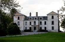
Originally a gabled house dating from about 1600, Leith Hill Place was completely refaced in a Palladian style about 1760 by Richard Hull.[10] It was bought in 1847 by Josiah Wedgwood III[11] and remained in the family until the composer Ralph Vaughan Williams, who had been brought up there and eventually inherited it, gave it to the National Trust in 1944. Subsequently it was leased from the Trust by his cousins Sir Ralph Wedgwood and then Sir John Wedgwood, later becoming a boarding house for a nearby sixth form college, Hurtwood House. The property is claimed to be haunted, with several School Masters of the day reporting strange goings-on, noises and even apparitions. The house was opened to the public by the National Trust in 2013 and now serves as a memorial to Ralph Vaughan Williams.[12]
Josiah Wedgwood's widow, born Caroline Darwin, created a rhododendron wood there, now open to the public.[13]
Geology
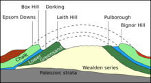
Like the other summits of the Greensand Ridge in the south of Surrey, the rock of which Leith Hill is composed, is primarily the Lower Greensand, overlaid with a harder layer of chert.[14] The greensand was deposited in the early Cretaceous, most likely in a shallow sea with low oxygen levels. Over the subsequent 50 million years, other strata were deposited on top of the Lower Greensand, including Gault clay and the chalk of the North and South Downs.[2]
Following the Cretaceous, the sea covering the south of England began to retreat and the land was pushed higher. The Weald (the area covering modern day south Surrey, south Kent, north Sussex and east Hampshire) was lifted by the same geological processes that created the Alps, resulting in an anticline which stretched across the English Channel to the Artois region of northern France. Initially an island, this dome-like structure was drained by the ancestors of the rivers which today cut through the North and South Downs (including the Mole, Wey and Arun).[note 3] The dome was eroded away over the course of the Cenozoic, exposing the strata beneath and resulting in the escarpments of the Downs and the Greensand Ridge.[2]
Search for oil
A site on an ancient lane going up the hill was originally chosen by an oil company for exploratory drilling, however due to an active protest campaign and various legal objections raised by local groups and environmentalists, the lease on the land from the Forestry Commission expired before the drilling could start. The Minister for Environment subsequently decided not to renew the lease due to concerns of the effect it would have on nearby ancient woodland. The oil company has since stated it intends to find a new site from which to explore the same prospect. Locals have stated that they will continue to oppose this.[15]
Geodesy
Leith Hill Tower was the origin (meridian) of the 6 inch and 1:2500 Ordnance Survey maps of Surrey.[16]
References
- Dawson, Alan (1992). "The Marilyns by Height". The Relative Hills of Britain. Milnthorpe, Cumbria, England: Cicerone Press. ISBN 1-85284-068-4. Archived from the original on 22 August 2010. Dawson draws his information from various editions of Ordnance Survey maps, but he does not specify which.
- Gallois, RW; Edmunds, MA (1965). The Wealden District. British Geological Survey. ISBN 0-11-884078-9.
- Bench marks km square TQ1343: The exact height of the benchmark on the tower, surveyed in 1972, is 293.8730 metres AMSL. The cut mark is 0.5 m off the ground, hence a height of 293.4 m. On the 1:50000 ordnance map this is rounded to 294 m. Dorking, Reigate and Crawley area (Map) (10GSGS ed.). 1:50000. Landranger 187. Ordnance Survey. 1991. ISBN 0-319-22187-3.
- "Designated Sites View: Leith Hill". Sites of Special Scientific Interest. Natural England. Retrieved 9 November 2018.
- Historic England. "Leith Hill Tower (1028808)". National Heritage List for England.
- surreyhills.org Archived 14 February 2012 at the Wayback Machine
- Grieves K (2008). "Leith Hill, Surrey: Landscape, Locality and Nation in the Era of the Great War". Landscapes. 9 (2): 45–69. doi:10.1179/lan.2008.9.2.45.
- "Lieutenant John Harcourt Chichester EVELYN. Princess Louise's (Argyll and Sutherland Highlanders)". The National Archives. 1914–1919. Retrieved 28 July 2020.CS1 maint: date format (link)
- Bailey J (23 March 1923). "Leith Hill: Tower and five acres purchased". The Times (43297). London. p. 13.
- Ian Nairn and Nikolaus Pevsner, Buildings of England - Surrey, Penguin, 1962
- Historic England. "Leith Hill Place (1028801)". National Heritage List for England.
- Leith Hill Place Archived 20 March 2014 at the Wayback Machine, accessed 18 October 2015
- gardenvisit.com
- Bennison, GM; Wright, AE (1969). The geological history of the British Isles. London: Edward Arnold. p. 321.
- "Oil firm withdraws test drilling plans". BBC News. 4 September 2018. Retrieved 5 September 2018.
- https://www.charlesclosesociety.org/files/153Meridians.pdf
Notes
- John H. C. Evelyn served as a lieutenant in the Argyll and Sutherland Highlanders (a British Army line infantry regiment) during World War I.[8] He was badly injured at the Western Front and his leg was amputated in October 1918. He died on 2 January 1922.[7]
- The MacAndrew family sold their stake in the business in June 1917. The company survives to this day as part of the French container transportation firm CMA CGM.
- Leith Hill forms the watershed between the Mole (to the north east), the Wey (to the north west), and the Arun (to the south).
External links
| Wikimedia Commons has media related to Leith Hill. |
| Wikivoyage has a travel guide for Leith Hill. |
- Leith Hill information at the National Trust
- Computer generated summit panoramas North South index
|
|  | ||||||||||||||||
|---|---|---|---|---|---|---|---|---|---|---|---|---|---|---|---|---|---|---|
| Parks | ||||||||||||||||||
| Places of worship |
| |||||||||||||||||
| Education | ||||||||||||||||||
| Transport |
| |||||||||||||||||
Buildings and structures | ||||||||||||||||||
| Sport |
| |||||||||||||||||
Places listed are articles notable as settlements, arranged by post town The two principal towns are emboldened | ||||||||||||||||||