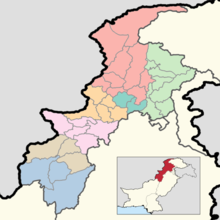
Districts of Khyber Pakhtunkhwa
The province of Khyber Pakhtunkhwa, the third-largest province of Pakistan by population and the smallest province by area, is divided into 35 districts and seven divisions. Below, you will find an overview of the recent history of districts in Khyber Pakhtunkhwa, a map showing each district, the divisions of Khyber Pakhtunkhwa and their districts, and a list showing each district's name, the division the district belongs to, the district's area, the location of the district's headquarters, the district's population and population density (in 2017), the average annual population growth rate of each district (between 1998 and 2017), and a map showing each district's location.
| Districts of Khyber Pakhtunkhwa | |
|---|---|
 | |
| Location | Khyber Pakhtunkhwa, Pakistan |
| Number | 35 (as of August 15, 2020) |
| Populations | 169,240 (Upper Chitral District) – 4,333,770 (Peshawar District) |
| Areas | 454 square kilometres (175 sq mi) (Torghar District) – 9,334 square kilometres (3,604 sq mi) (Dera Ismail Khan District) |
| Government | District Government City District Government Zilla Council |
| Subdivisions | Tehsils |
Recent History
During the 1998 Census of Pakistan, Khyber Pakhtunkhwa had 24 districts.[1] No changes occurred to this setup for over a decade, until 2011, when Kala Dhaka Tehsil was separated from Mansehra District to become Torghar District,[2] the 25th district of Khyber Pakhtunkhwa. These 25 districts (the 24 districts dating to 1998 and Torghar) were the only districts recorded as a part of Khyber Pakhtunkhwa during the 2017 Census.[3] Kohistan District was bifurcated into Upper Kohistan District and Lower Kohistan District in 2014,[4] but tensions on the bifurcation[5] did not resolve until 2017, when Kolai-Palas District was formed as well.[6]
On May 31, 2018, the Twenty-fifth Amendment to the Constitution of Pakistan was put into force. This amendment merged the Federally Administered Tribal Areas with the province of Khyber Pakhtunkhwa and changes the province's borders and layout drastically. Each of the seven agencies in the Federally Administered Tribal Areas (Bajaur, Kurram, Khyber, Mohmand, North Waziristan, Orakzai, and South Waziristan) was made into its own district and added into an adjacent division (Bajaur District became a part of Malakand Division, Khyber and Mohmand Districts joined Peshawar Division, Kurram and Orakzai Districts joined Kohat Division, North Waziristan District joined Bannu Division, and South Waziristan District joined Dera Ismail Khan Division). The six Frontier Regions joined the districts they were adjacent to (Frontier Region Bannu was incorporated into Bannu District, Frontier Region Kohat was incorporated into Kohar District etc.). In late 2018, Chitral District, formerly the largest district in the province by area, was bifurcated into Upper Chitral District, from Mastuj Tehsil, and Lower Chitral District, from Chitral Tehsil.[7] This raised the number of districts in the province to 35, where it stands to this day.
Current Map

Divisions of Khyber Pakhtunkhwa
In Pakistan, the division is the administrative unit which is higher in hierarchy than a district, but lower in hierarchy than a province. There are seven divisions in Khyber Pakhtunkhwa, each of which have anywhere between two and nine districts. They are separated by color on the map above, and you can find a list of them below.
| Division [8] | Districts[8][9] | Population (2017)[8] | Total Area[10] | Population Density (2017) | Map |
|---|---|---|---|---|---|
| Bannu Division |
|
2,656,801 | 9,975 km2 (3,851 sq mi) | 266.35/km2 (689.8/sq mi) |  |
| Dera Ismail Khan Division |
|
2,803,147 | 18,854 km2 (7,280 sq mi) | 148.68/km2 (385.1/sq mi) | 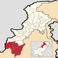 |
| Hazara Division |
|
5,325,121 | 17,064 km2 (6,588 sq mi) | 312.07/km2 (808.3/sq mi) | 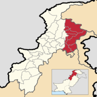 |
| Kohat Division |
|
3,211,458 | 12,377 km2 (4,779 sq mi) | 259.47/km2 (672.0/sq mi) |  |
| Malakand Division | 8,608,378 | 31,162 km2 (12,032 sq mi) | 276.25/km2 (715.5/sq mi) | 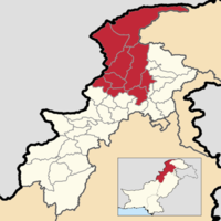 | |
| Mardan Division | 3,997,677 | 3,175 km2 (1,226 sq mi) | 1,259.11/km2 (3,261.1/sq mi) |  | |
| Peshawar Division | 8,922,465 | 9,134 km2 (3,527 sq mi) | 976.84/km2 (2,530.0/sq mi) | 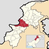 |
List of Districts
Below you will find a list of all 35 districts in the province of Khyber Pakhtunkhwa, along with the division it belongs to, the area of the district, the population and population density of the district, the average annual population growth rate of each district (between 1998 and 2017), and a map showing its location. The districts are initially listed in alphabetical order, but they can be sorted in different ways by clicking the headers of the table.
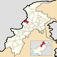
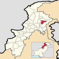
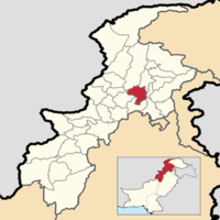
| Name | Division[8][9] | Population (2017)[8][11] | Total Area[10] | Population Density (2017) | Average Annual Population Growth Rate (1998 - 2017)[8] | Map |
|---|---|---|---|---|---|---|
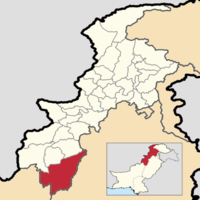
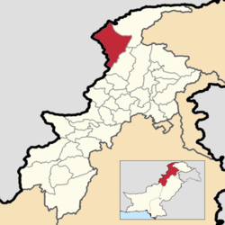
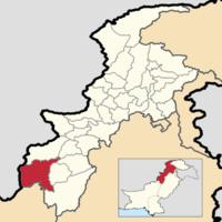
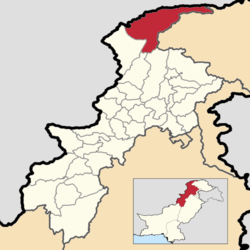
| Abbottabad District | Hazara Division | 1,332,912 | 1,967 km2 (759 sq mi) | 677.64/km2 (1,755.1/sq mi) | 2.20% |
 |
| Bajaur District | Malakand Division | 1,093,684 A | 1,290 km2 (500 sq mi) | 847.82/km2 (2,195.8/sq mi) | 3.25% |
 |
| Bannu District | Bannu Division | 1,211,006 B | 1,972 km2 (761 sq mi) | 614.10/km2 (1,590.5/sq mi) | 2.96% |
 |
| Batagram District | Hazara Division | 476,612 | 1,301 km2 (502 sq mi) | 366.34/km2 (948.8/sq mi) | 2.33% |
 |
| Buner District | Malakand Division | 897,319 | 1,865 km2 (720 sq mi) | 481.14/km2 (1,246.1/sq mi) | 3.05% |
 |
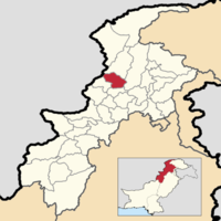
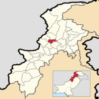
| Charsadda District | Peshawar Division | 1,616,198 | 996 km2 (385 sq mi) | 1,622.69/km2 (4,202.7/sq mi) | 2.43% |
 |
| Dera Ismail Khan District | Dera Ismail Khan Division | 1,695,688 C | 9,334 km2 (3,604 sq mi) | 181.67/km2 (470.5/sq mi) | 3.43% |
 |
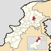
| Hangu District | Kohat Division | 518,798 | 1,097 km2 (424 sq mi) | 472.92/km2 (1,224.9/sq mi) | 2.66% |
 |
| Haripur District | Hazara Division | 1,003,031 | 1,725 km2 (666 sq mi) | 581.47/km2 (1,506.0/sq mi) | 1.97% |
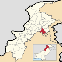 |
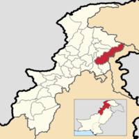
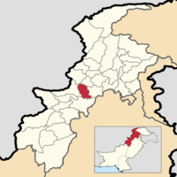
| Karak District | Kohat Division | 706,299 | 3,371 km2 (1,302 sq mi) | 209.52/km2 (542.7/sq mi) | 2.63% |
 |
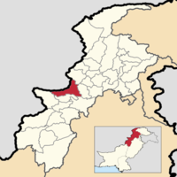
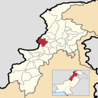
| Khyber District | Peshawar Division | 986,973 D | 2,576 km2 (995 sq mi) | 383.14/km2 (992.3/sq mi) | 3.15% |
 |
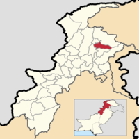
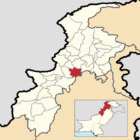
| Kohat District | Kohat Division | 1,112,452 E | 2,991 km2 (1,155 sq mi) | 371.93/km2 (963.3/sq mi) | 2.85% |
 |
| Kolai-Palas District | Hazara Division | 275,461 F S [11] | N/A | N/A | 2.71% |
 |
| Kurram District | Kohat Division | 619,553 G | 3,380 km2 (1,310 sq mi) | 183.30/km2 (474.7/sq mi) | 1.71% |
 |
| Lakki Marwat District | Bannu Division | 902,541 H | 3,296 km2 (1,273 sq mi) | 273.83/km2 (709.2/sq mi) | 3.18% |
 |
| Lower Chitral District | Malakand Division | 278,122 I | 6,458 km2 (2,493 sq mi) | 43.06/km2 (111.5/sq mi) | 2.17% |
 |
| Lower Dir District | Malakand Division | 1,435,917 | 1,583 km2 (611 sq mi) | 907.09/km2 (2,349.4/sq mi) | 3.71% |
 |
| Lower Kohistan District | Hazara Division | 202,913 J S [11] | N/A | N/A | 2.70% |
 |
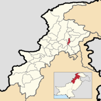
| Malakand District | Malakand Division | 720,295 | 952 km2 (368 sq mi) | 756.61/km2 (1,959.6/sq mi) | 2.47% |
 |
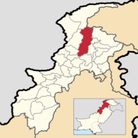
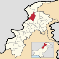
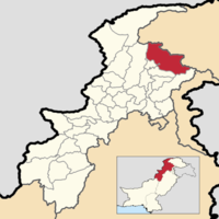
| Mansehra District | Hazara Division | 1,556,460 | 4,125 km2 (1,593 sq mi) | 377.32/km2 (977.3/sq mi) | 2.47% |
 |
| Mardan District | Mardan Division | 2,373,061 | 1,632 km2 (630 sq mi) | 1,454.08/km2 (3,766.0/sq mi) | 2.58% |
 |
| Mohmand District | Peshawar Division | 466,984 K | 2,296 km2 (886 sq mi) | 203.39/km2 (526.8/sq mi) | 1.77% |
 |
| North Waziristan District | Bannu Division | 543,254 L | 4,707 km2 (1,817 sq mi) | 115.41/km2 (298.9/sq mi) | 2.17% |
 |
| Nowshera District | Peshawar Division | 1,518,540 | 1,748 km2 (675 sq mi) | 868.73/km2 (2,250.0/sq mi) | 2.94% |
 |
| Orakzai District | Kohat Division | 254,356 M | 1,538 km2 (594 sq mi) | 165.38/km2 (428.3/sq mi) | 0.64% |
 |
| Peshawar District | Peshawar Division | 4,333,770 N | 1,518 km2 (586 sq mi) | 2,854.92/km2 (7,394.2/sq mi) | 3.93% |
 |
| Shangla District | Malakand Division | 757,810 | 1,586 km2 (612 sq mi) | 477.81/km2 (1,237.5/sq mi) | 2.96% |
 |
| South Waziristan District | Dera Ismail Khan Division | 679,185 O | 6,620 km2 (2,560 sq mi) | 102.60/km2 (265.7/sq mi) | 2.43% |
 |
| Swabi District | Mardan Division | 1,624,616 | 1,543 km2 (596 sq mi) | 1,052.89/km2 (2,727.0/sq mi) | 2.44% |
 |
| Swat District | Malakand Division | 2,309,570 | 5,337 km2 (2,061 sq mi) | 432.75/km2 (1,120.8/sq mi) | 3.24% |
 |
| Tank District | Dera Ismail Khan Division | 428,274 P | 2,900 km2 (1,100 sq mi) | 147.68/km2 (382.5/sq mi) | 2.54% |
 |
| Tor Ghar District | Hazara Division | 171,395 | 454 km2 (175 sq mi) | 377.52/km2 (977.8/sq mi) | -0.10% |
 |
| Upper Chitral District | Malakand Division | 169,240 Q | 8,392 km2 (3,240 sq mi) | 20.17/km2 (52.2/sq mi) | 1.24% |
 |
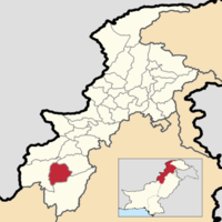
| Upper Dir District | Malakand Division | 946,421 | 3,699 km2 (1,428 sq mi) | 255.86/km2 (662.7/sq mi) | 2.64% |
 |
| Upper Kohistan District | Hazara Division | 306,337 R [11] | 4,158 km2 (1,605 sq mi) | 73.67/km2 (190.8/sq mi) | 2.69% |
 |
See also
- Districts of Pakistan
- Districts of Punjab (Pakistan)
- Districts of Sindh
- Districts of Balochistan (Pakistan)
- Districts of Azad Kashmir
- Districts of Gilgit-Baltistan
- Divisions of Pakistan
Pakistan articles | |||||||||||||||||||
|---|---|---|---|---|---|---|---|---|---|---|---|---|---|---|---|---|---|---|---|
| |||||||||||||||||||
| |||||||||||||||||||
| |||||||||||||||||||
| |||||||||||||||||||
| |||||||||||||||||||
| |||||||||||||||||||
| History | |
|---|---|
| Government | |
| Culture and places |
|
| Geography |
|
| Education & Health | |
| Sport |
|
| |
Notes
- A. ^ In 2017 Bajaur District was not a district of Khyber Pakhtunkhwa, but was an agency in FATA.
- B. ^ In 2017 Bannu District was split into both the "Frontier Region Bannu" (a part of FATA) and "Bannu District".
- C. ^ In 2017 Dera Ismail Khan District was split into both the "Frontier Region Dera Ismail Khan" (a part of FATA) and "Dera Ismail Khan District".
- D. ^ In 2017 Khyber District was not a district of Khyber Pakhtunkhwa, but was an agency in FATA.
- E. ^ In 2017 Kohat District was split into both the "Frontier Region Kohat" (a part of FATA) and "Kohat District".
- F. ^ In 2017 Kolai-Palas District was not a district, but a part of the erstwhile Kohistan District. Today it occupies the area the Palas Tehsil used to occupy. Also, due to discrepancies in the source regarding the population of each of Kohistan's Tehsils (when the Tehsils are added one person is missing), a different and more up to date source[11] is used for the districts covering the Kohistan region.
- G. ^ In 2017 Kurram District was not a district of Khyber Pakhtunkhwa, but was an agency in FATA.
- H. ^ In 2017 Lakki Marwat District was split into both the "Frontier Region Lakki Marwat" (a part of FATA) and "Lakki Marwat District".
- I. ^ In 2017 Lower Chitral District was not a district, but a part of the erstwhile Chitral District. Today it occupies the area the Chitral Tehsil (or Chitral Subdivision) used to occupy.
- J. ^ In 2017 Lower Kohistan District was not a district, but a part of the erstwhile Kohistan District. Today it occupies the area the Pattan Tehsil used to occupy. Also, due to discrepancies in the source regarding the population of each of Kohistan's Tehsils (when the Tehsils are added one person is missing), a different and more up to date source[11] is used for the districts covering the Kohistan region.
- K. ^ In 2017 Mohmand District was not a district of Khyber Pakhtunkhwa, but was an agency in FATA.
- L. ^ In 2017 North Waziristan District was not a district of Khyber Pakhtunkhwa, but was an agency in FATA.
- M. ^ In 2017 Orakzai District was not a district of Khyber Pakhtunkhwa, but was an agency in FATA.
- N. ^ In 2017 Peshawar District was split into both the "Frontier Region Peshawar" (a part of FATA) and "Peshawar District".
- O. ^ In 2017 South Waziristan District was not a district of Khyber Pakhtunkhwa, but was an agency in FATA.
- P. ^ In 2017 Tank District was split into both the "Frontier Region Tank" (a part of FATA) and "Tank District".
- Q. ^ In 2017 Upper Chitral District was not a district, but a part of the erstwhile Chitral District. Today it occupies the area the Mastuj Tehsil (or Mastuj Subdivision) used to occupy.
- R. ^ In 2017 Upper Kohistan District was not a district, but a part of the erstwhile Kohistan District. Today it occupies the area the Dassu and Kandia Tehsils used to occupy (between 1998 Kandia Tehsil split off from Dassu Tehsil). Also, due to discrepancies in the source regarding the population of each of Kohistan's Tehsils (when the Tehsils are added one person is missing), a different and more up to date source[11] is used for the districts covering the Kohistan region.
- S. ^ No area data is given for Kolai-Palas District and Lower Kohistan District because in the source (dated 1998), Palas Tehsil (which became Kolai-Palas) and Pattan Tehsil (which became Lower Kohistan), even though their populations were reported separately, the area that was given was the combined area of both tehsils. The combined area of both tehsils (which are today districts) is 3,334 km2 (1,287 sq mi).
References
- "Khyber Pakhtunkhwa". Khyber Pakhtunkhwa | Pakistan Bureau of Statistics. Pakistan Bureau of Statistics. Archived from the original on June 15, 2020. Retrieved 15 June 2020.
- "Tor Ghar: Kala Dhaka becomes 25th K-P District". Tor Ghar: Kala Dhaka becomes 25th K-P District - The Express Tribune. The Express Tribune. 28 January 2011. Archived from the original on 5 July 2017. Retrieved 15 June 2020.
- "TABLE - 1: PROVISIONAL PROVINCE WISE POPULATION BY SEX AND RURAL/URBAN CENSUS - 2017 PAKISTAN" (PDF). DISTRICT_WISE_CENSUS_RESULTS_CENSUS_2017.pdf. Pakistan Bureau of Statistics. Archived from the original (PDF) on June 15, 2020. Retrieved 15 June 2020.
- "Kohistan bifurcated in lower and upper districts". Kohistan bifurcated in lower and upper districts. The News International. 16 January 2014. Archived from the original on 15 June 2020. Retrieved 15 June 2020.
- Nisar Ahmad Khan (24 January 2017). "People of Pales to seek review of SC's Kohistan bifurcation verdict". People of Pales to seek review of SC’s Kohistan bifurcation verdict - Newspaper - DAWN.COM. Dawn. Archived from the original on 15 June 2020. Retrieved 15 June 2020.
- "Kolai-Palas notified as new district". Kolai-Palas notified as new district. The News International. 26 August 2017. Archived from the original on 15 June 2020. Retrieved 15 June 2020.
- "Chitral bifurcated into two districts". Chitral bifurcated into two districts - Chitral Today. Chitral Today. Retrieved 15 June 2020.
- "PROVINCE WISE PROVISIONAL RESULTS OF CENSUS - 2017" (PDF). PAKISTAN TEHSIL WISE FOR WEB CENSUS_2017.pdf. Pakistan Bureau of Statistics. Archived from the original (PDF) on 16 June 2020. Retrieved 16 June 2020.
- "KP govt notifies new divisions following FATA merger". KP govt notifies new divisions following FATA merger | Pakistan Today. Pakistan Today. 20 July 2018. Archived from the original on 2 July 2020. Retrieved 2 July 2020.
- "TABLE-1: AREA & POPULATION OF ADMINISTRATIVE UNITS BY RURAL/URBAN: 1951-1998 CENSUSES" (PDF). Administrative Units.pdf. Pakistan Bureau of Statistics. Archived (PDF) from the original on 20 June 2020. Retrieved 20 June 2020.
- "POPULATION AND HOUSEHOLD DETAIL FROM BLOCK TO DISTRICT LEVEL KHYBER PAKHTUNKHWA (KOHISTAN DISTRICT)" (PDF). KOHISTAN_BLOCKWISE.pdf. Pakistan Bureau of Statistics. 3 January 2018. Archived from the original (PDF) on 11 July 2020. Retrieved 11 July 2020.