Dennis Township, New Jersey
Dennis Township is a township in Cape May County, New Jersey, United States. It is part of the Ocean City Metropolitan Statistical Area. The township's population as of the 2010 United States Census was 6,467,[7][8][9] reflecting a decline of 25 (-0.4%) from the 6,492 counted in the 2000 Census, which had in turn increased by 918 (+16.5%) from the 5,574 counted in the 1990 Census.[18]
Dennis Township, New Jersey | |
|---|---|
| Township of Dennis | |
 | |
 Dennis Township highlighted in Cape May County. Inset map: Cape May County highlighted in the State of New Jersey. | |
 Census Bureau map of Dennis Township, New Jersey | |
 Dennis Township Location in Cape May County 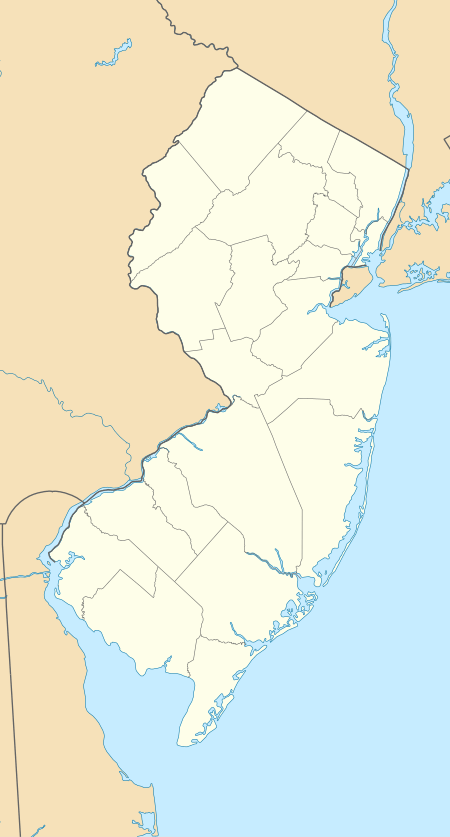 Dennis Township Location in New Jersey  Dennis Township Location in the United States | |
| Coordinates: 39.206513°N 74.818417°W[1][2] | |
| Country | |
| State | |
| County | Cape May |
| Incorporated | March 1, 1827 |
| Government | |
| • Type | Township |
| • Body | Township Committee |
| • Mayor | Zeth Anthony Matalucci (R, term ends December 31, 2020)[4][5] |
| • Administrator | Jessica Bishop[4] |
| • Municipal clerk | Jacqueline Justice[4] |
| Area | |
| • Total | 64.328 sq mi (166.611 km2) |
| • Land | 60.799 sq mi (157.470 km2) |
| • Water | 3.529 sq mi (9.141 km2) 5.49% |
| Area rank | 19th of 566 in state 3rd of 16 in county[1] |
| Elevation | 16 ft (5 m) |
| Population | |
| • Total | 6,467 |
| • Estimate (2019)[10] | 6,144 |
| • Rank | 330th of 566 in state 5th of 16 in county[11] |
| • Density | 106.4/sq mi (41.1/km2) |
| • Density rank | 540th of 566 in state 16th of 16 in county[11] |
| Time zone | UTC−05:00 (Eastern (EST)) |
| • Summer (DST) | UTC−04:00 (Eastern (EDT)) |
| ZIP Code | |
| Area code(s) | 609 exchanges: 624, 861[14] |
| FIPS code | 3400917560[1][15][16] |
| GNIS feature ID | 0882046[1][17] |
| Website | www |
Dennis Township was incorporated as a township by an act of the New Jersey Legislature on March 1, 1827, from portions of Upper Township. Portions of the township were taken to form Sea Isle City borough (May 22, 1882) and Woodbine borough (March 3, 1903).[19]
New Jersey Monthly magazine ranked Dennis Township as its 20th best place to live in its 2008 rankings of the "Best Places To Live" in New Jersey.[20]
History
Dennis Township had been a dry town, where alcohol could not be sold, until 2001 when voters passed a referendum allowing liquor to be sold; the township council authorized the sale of a single license, which netted the township $1.1 million.[21][22]
Geography
According to the United States Census Bureau, the township had a total area of 64.328 square miles (166.611 km2), including 60.799 square miles (157.470 km2) of land and 3.529 square miles (9.141 km2) of water (5.49%).[1][2]
Belleplain (2010 Census population of 597[23]) is an unincorporated community and census-designated place (CDP) located within the township.[24]
Dennisville is the most important unincorporated community in Dennis Township. Ocean View is served as ZIP Code 08230.[25] Other communities, localities and place names located partially or completely within the township include Clermont, East Creek, Eldora, Mount Pleasant, North Dennis, North-West Dennis, Ocean View, Savage Pond, South Dennis, South Seaville, Stipsons Island and West Creek Landing.[26][27]
The township borders the municipalities of Avalon, Middle Township, Sea Isle City, Upper Township, Woodbine Borough in Cape May County; portions of Cumberland County, and the Delaware Bay.[28][29][30]
Demographics
| Historical population | |||
|---|---|---|---|
| Census | Pop. | %± | |
| 1830 | 1,513 | — | |
| 1840 | 1,350 | −10.8% | |
| 1850 | 1,604 | 18.8% | |
| 1860 | 1,558 | −2.9% | |
| 1870 | 1,640 | 5.3% | |
| 1880 | 1,812 | 10.5% | |
| 1890 | 1,707 | * | −5.8% |
| 1900 | 2,778 | 62.7% | |
| 1910 | 1,751 | * | −37.0% |
| 1920 | 1,639 | −6.4% | |
| 1930 | 1,615 | −1.5% | |
| 1940 | 1,877 | 16.2% | |
| 1950 | 1,981 | 5.5% | |
| 1960 | 2,327 | 17.5% | |
| 1970 | 2,635 | 13.2% | |
| 1980 | 3,989 | 51.4% | |
| 1990 | 5,574 | 39.7% | |
| 2000 | 6,492 | 16.5% | |
| 2010 | 6,467 | −0.4% | |
| Est. 2019 | 6,144 | [10][31][32] | −5.0% |
| Population sources:1830-2000[33] 1830-1920[34] 1840[35] 1850-1870[36] 1850[37] 1870[38] 1880-1890[39] 1890-1910[40] 1910-1930[41] 1930-1990[42] 2000[43][44] 2010[7][8][9] * = Lost territory in previous decade.[19] | |||
Census 2010
The 2010 United States Census counted 6,467 people, 2,370 households, and 1,791.720 families in the township. The population density was 106.4 per square mile (41.1/km2). There were 2,672 housing units at an average density of 43.9 per square mile (16.9/km2). The racial makeup was 96.75% (6,257) White, 0.79% (51) Black or African American, 0.19% (12) Native American, 0.56% (36) Asian, 0.03% (2) Pacific Islander, 0.32% (21) from other races, and 1.36% (88) from two or more races. Hispanic or Latino of any race were 1.81% (117) of the population.[7]
Of the 2,370 households, 29.5% had children under the age of 18; 60.8% were married couples living together; 9.5% had a female householder with no husband present and 24.4% were non-families. Of all households, 19.6% were made up of individuals and 8.6% had someone living alone who was 65 years of age or older. The average household size was 2.68 and the average family size was 3.07.[7]
21.4% of the population were under the age of 18, 8.6% from 18 to 24, 20.9% from 25 to 44, 34.1% from 45 to 64, and 15.0% who were 65 years of age or older. The median age was 44.5 years. For every 100 females, the population had 96.9 males. For every 100 females ages 18 and older there were 94.1 males.[7]
The Census Bureau's 2006-2010 American Community Survey showed that (in 2010 inflation-adjusted dollars) median household income was $84,205 (with a margin of error of +/- $5,160) and the median family income was $84,400 (+/- $4,219). Males had a median income of $52,571 (+/- $3,535) versus $40,023 (+/- $5,496) for females. The per capita income for the borough was $30,545 (+/- $2,875). About 5.4% of families and 7.6% of the population were below the poverty line, including 12.0% of those under age 18 and 5.4% of those age 65 or over.[45]
Census 2000
As of the 2000 United States Census[15] there were 6,492 people, 2,159 households, and 1,737 families residing in the township. The population density was 105.8 people per square mile (40.9/km2). There were 2,327 housing units at an average density of 37.9 per square mile (14.6/km2). The racial makeup of the township was 97.43% White, 0.96% African American, 0.09% Native American, 0.43% Asian, 0.02% Pacific Islander, 0.62% from other races, and 0.46% from two or more races. Hispanic or Latino of any race were 1.51% of the population.[43][44]
There were 2,159 households, out of which 41.7% had children under the age of 18 living with them, 65.9% were married couples living together, 9.8% had a female householder with no husband present, and 19.5% were non-families. 15.4% of all households were made up of individuals, and 5.7% had someone living alone who was 65 years of age or older. The average household size was 2.91 and the average family size was 3.24.[43][44]
In the township the population was spread out, with 28.3% under the age of 18, 6.4% from 18 to 24, 30.6% from 25 to 44, 22.5% from 45 to 64, and 12.3% who were 65 years of age or older. The median age was 37 years. For every 100 females, there were 96.5 males. For every 100 females age 18 and over, there were 93.4 males.[43][44]
The median income for a household in the township was $56,595, and the median income for a family was $61,445. Males had a median income of $41,404 versus $31,329 for females. The per capita income for the township was $21,455. About 4.0% of families and 5.5% of the population were below the poverty line, including 6.6% of those under age 18 and 4.2% of those age 65 or over.[43][44]
Government
Local government
Dennis Township is governed under the Township form of New Jersey municipal government, one of 141 of 565 municipalities statewide that use this form, the second-most commonly used form of government in the state.[46] The Township Committee is comprised of five members, who are elected directly by the voters at-large in partisan elections to serve three-year terms of office on a staggered basis, with either one or two seats coming up for election each year as part of the November general election in a three-year cycle.[3][47] At an annual reorganization meeting, the Township Committee selects one of its members to serve as Mayor and another as Deputy Mayor. The Committee members serve in a part-time capacity and receive an annual salary.[48]
The governing body originally consisted of three elected officials, one of which would be elected by the membership to serve as the Mayor. In 1989 voters approved a ballot question to increase the membership from three members to five members, and in November 1990 the voters elected two additional Committee members. The first five-member committee took office in January 1991 at which time the governing body established the position of Township Administrator.[48]
As of 2020, the members of the Dennis Township Committee are Mayor Zeth Anthony Matalucci (R, term on committee ends December 31, 2022; term as mayor ends 2020), Deputy Mayor Scott J. Turner (R, term on committee and as deputy mayor ends 2020), Matthew J. Cox (R, 2022), Frank L. Germanio Jr. (R, 2021) and Thomas Van Artsdalen III (R, 2020).[4][49][50][51][52][53][54]
In October 2017, the Township Committee appointed Nicolas Elisano to fill the seat expiring December 2019 that became vacant following the resignation of Melanie Smith, who was moving out of the township.[55] In November 2018, Matthew J. Cox was elected to serve the balance of the term of office.[53]
Federal, state and county representation
Dennis Township is located in the 2nd Congressional District[56] and is part of New Jersey's 1st state legislative district.[8][57][58]
For the 116th United States Congress, New Jersey's Second Congressional District is represented by Jeff Van Drew (R, Dennis Township).[59] New Jersey is represented in the United States Senate by Democrats Cory Booker (Newark, term ends 2021)[60] and Bob Menendez (Paramus, term ends 2025).[61][62]
For the 2020–2021 session (Senate, General Assembly), the 1st Legislative District of the New Jersey Legislature is represented in the State Senate by Mike Testa (R, Vineland) and in the General Assembly by Antwan McClellan (R, Ocean City) and Erik K. Simonsen (R, Lower Township).[63][64]
Cape May County is governed by a Board of Chosen Freeholders consisting of five members, elected at-large in partisan elections to three-year terms of office on a staggered basis, with one or two seats coming up for election each year; At an annual reorganization held each January, the freeholders select one member to serve as Director and another to serve as Vice-Director.[65] As of 2018, Cape May County's Freeholders are Freeholder Director Gerald M. Thornton (Republican Party, Cape May Court House in Middle Township; term as freeholder expires December 31, 2019, term as freeholder director ends 2018),[66] Freeholder Vice-Director Leonard C. Desiderio (R, Sea Isle City; term as freeholder and as freeholder vice-director ends 2018),[67] E. Marie Hayes (R, Ocean City; 2019),[68] Will Morey (R, Wildwood Crest; 2020)[69] and Jeffrey L. Pierson (R. Upper Township; 2020).[70][65][71][72] The county's constitutional officers are County Clerk Rita Marie Fulginiti (R, 2020, Ocean City),[73][74] Sheriff Robert Nolan (R, 2020, Lower Township)[75][76] and Surrogate Dean Marcolongo (R, 2022, Upper Township).[77][78][79][71]
Politics
As of March 23, 2011, there were a total of 4,499 registered voters in Dennis Township, of which 1,091 (24.2%) were registered as Democrats, 1,527 (33.9%) were registered as Republicans and 1,877 (41.7%) were registered as Unaffiliated. There were 4 voters registered to other parties.[80]
In the 2012 presidential election, Republican Mitt Romney received 55.5% of the vote (1,809 cast), ahead of Democrat Barack Obama with 43.1% (1,406 votes), and other candidates with 1.4% (45 votes), among the 3,296 ballots cast by the township's 4,624 registered voters (36 ballots were spoiled), for a turnout of 71.3%.[81][82] In the 2008 presidential election, Republican John McCain received 55.4% of the vote (1,904 cast), ahead of Democrat Barack Obama, who received 42.4% (1,459 votes), with 3,437 ballots cast among the township's 4,331 registered voters, for a turnout of 79.4%.[83] In the 2004 presidential election, Republican George W. Bush received 58.1% of the vote (1,977 ballots cast), outpolling Democrat John Kerry, who received around 40.0% (1,362 votes), with 3,401 ballots cast among the township's 4,424 registered voters, for a turnout percentage of 76.9.[84]
In the 2013 gubernatorial election, Republican Chris Christie received 69.1% of the vote (1,647 cast), ahead of Democrat Barbara Buono with 29.4% (702 votes), and other candidates with 1.5% (36 votes), among the 2,481 ballots cast by the township's 4,559 registered voters (96 ballots were spoiled), for a turnout of 54.4%.[85][86] In the 2009 gubernatorial election, Republican Chris Christie received 51.9% of the vote (1,251 ballots cast), ahead of both Democrat Jon Corzine with 37.1% (894 votes) and Independent Chris Daggett with 8.2% (197 votes), with 2,411 ballots cast among the township's 4,572 registered voters, yielding a 52.7% turnout.[87]
Education
The Dennis Township Public Schools serve students in pre-kindergarten through eighth grade.[88] As of the 2017–18 school year, the district, comprising two schools, had an enrollment of 564 students and 68.3 classroom teachers (on an FTE basis), for a student–teacher ratio of 8.3:1.[89] Schools in the district (with 2017-18 enrollment from the National Center for Education Statistics[90]) are Dennis Township Primary School for grades PreK-3 (279 students) and Dennis Township Elementary / Middle School for grades 4-8 (272 students).[91][92]
Students in public school for ninth through twelfth grades attend Middle Township High School in Cape May Court House, together with students from Avalon, Stone Harbor and Woodbine, as part of a sending/receiving relationship with the Middle Township Public Schools.[93][94] As of the 2017–18 school year, the high school had an enrollment of 807 students and 67.5 classroom teachers (on an FTE basis), for a student–teacher ratio of 12.0:1.[95]
Students are also eligible to attend the Cape May County Technical High School in Cape May Court House, which serves students from the entire county in its comprehensive and vocational programs, which are offered without charge to students who are county residents.[96][97]
Transportation
_just_south_of_Exit_17_in_Dennis_Township%2C_Cape_May_County%2C_New_Jersey.jpg)
As of May 2010, the township had a total of 112.5 miles (181.1 km) of roadways, of which 58.7 miles (94.5 km) were maintained by the municipality, 32.9 miles (52.9 km) by Cape May County, 16.7 miles (26.9 km) by the New Jersey Department of Transportation and 4.2 miles (6.8 km) by the New Jersey Turnpike Authority.[98]
The Garden State Parkway is the most prominent highway serving Dennis Township, running for more than 4.1 miles (6.6 km) through the township.[99] Other significant roads serving the township include U.S. Route 9, New Jersey Route 47, New Jersey Route 83 and New Jersey Route 347.
Notable people
People who were born in, residents of, or otherwise closely associated with Dennis Township include:
- Jonathan Maslow (1948-2008), author who wrote extensively about nature, with a focus on obscure and little-understood animals.[100]
- Willie Royster (1954-2015), catcher who played in four games for the Baltimore Orioles in 1981.[101]
- Jeff Van Drew (born 1953), U.S. Representative for New Jersey's 2nd congressional district and former member of the New Jersey Senate, representing the 1st legislative district.[102]
References
- 2010 Census Gazetteer Files: New Jersey County Subdivisions, United States Census Bureau. Accessed May 21, 2015.
- US Gazetteer files: 2010, 2000, and 1990, United States Census Bureau. Accessed September 4, 2014.
- 2012 New Jersey Legislative District Data Book, Rutgers University Edward J. Bloustein School of Planning and Public Policy, March 2013, p. 8.
- Township Personnel, Township of Dennis. Accessed March 27, 2020.
- 2020 New Jersey Mayors Directory, New Jersey Department of Community Affairs. Accessed February 1, 2020.
- U.S. Geological Survey Geographic Names Information System: Township of Dennis, Geographic Names Information System. Accessed March 5, 2013.
- DP-1 - Profile of General Population and Housing Characteristics: 2010 for Dennis township, Cape May County, New Jersey Archived February 12, 2020, at Archive.today, United States Census Bureau. Accessed October 16, 2012.
- Municipalities Sorted by 2011-2020 Legislative District, New Jersey Department of State. Accessed February 1, 2020.
- Profile of General Demographic Characteristics: 2010 for Dennis township Archived 2012-04-30 at the Wayback Machine, New Jersey Department of Labor and Workforce Development. Accessed October 16, 2012.
- QuickFacts for Dennis township, Cape May County, New Jersey; Cape May County, New Jersey; New Jersey from Population estimates, July 1, 2019, (V2019), United States Census Bureau. Accessed May 21, 2020.
- GCT-PH1 Population, Housing Units, Area, and Density: 2010 - State -- County Subdivision from the 2010 Census Summary File 1 for New Jersey Archived February 12, 2020, at Archive.today, United States Census Bureau. Accessed October 16, 2012.
- Look Up a ZIP Code for Dennisville, NJ, United States Postal Service. Accessed October 16, 2012.
- Zip Codes, State of New Jersey. Accessed September 3, 2013.
- Area Code Lookup - NPA NXX for Dennis, NJ, Area-Codes.com. Accessed September 3, 2013.
- U.S. Census website , United States Census Bureau. Accessed September 4, 2014.
- Geographic codes for New Jersey, Missouri Census Data Center. Accessed October 16, 2012.
- US Board on Geographic Names, United States Geological Survey. Accessed September 4, 2014.
- Table 7. Population for the Counties and Municipalities in New Jersey: 1990, 2000 and 2010, New Jersey Department of Labor and Workforce Development, February 2011. Accessed October 16, 2012.
- Snyder, John P. The Story of New Jersey's Civil Boundaries: 1606-1968, Bureau of Geology and Topography; Trenton, New Jersey; 1969. p. 114. Accessed October 16, 2012.
- "Best Places To Live - The Complete Top Towns List 1-100" Archived February 28, 2008, at the Wayback Machine, New Jersey Monthly, February 21, 2008. Accessed February 24, 2008.
- Procida, Lee. "Cape May County towns relaxing liquor laws as area's alcohol culture changes", Press of Atlantic City, April 14, 2012. Accessed October 16, 2017. "Voters in West Cape May turned down the sale of liquor twice in its history before approving a referendum less than four years ago, and Dennis Township repealed its dry status in 2001."
- Tomlinson, Phillip. "Maurice River discussing alcohol sales; diner owner in dry town pursuing issue", South Jersey Times, March 18, 2012. Accessed October 16, 2017. "Nearby Dennis Township approved the sale of a liquor license in 2001, which sold at auction for $1.1 million."
- DP-1 - Profile of General Population and Housing Characteristics: 2010 Demographic Profile Data for Belleplain CDP, New Jersey Archived February 12, 2020, at Archive.today, United States Census Bureau. Accessed October 16, 2012.
- New Jersey: 2010 - Population and Housing Unit Counts - 2010 Census of Population and Housing (CPH-2-32), United States Census Bureau, August 2012. Accessed October 16, 2012.
- Look Up a ZIP Code for Ocean View, NJ, United States Postal Service. Accessed December 17, 2014.
- Locality Search, State of New Jersey. Accessed December 17, 2014.
- Old School House Museum & History Center, Township of Dennis. Accessed March 27, 2020. "The Dennis Township Museum is devoted to the collection of artifacts, historic documents, memorabilia and photographs which tells the story of our local communities of Belleplain, Clermont, Dennisville, Eldora, Northwest Dennis, Ocean View, South Dennis and South Seaville. "
- Areas touching Dennis Township, MapIt. Accessed March 27, 2020.
- Cape May County, Coalition for a Healthy NJ. Accessed March 27, 2020.
- New Jersey Municipal Boundaries, New Jersey Department of Transportation. Accessed November 15, 2019.
- Annual Estimates of the Resident Population for Minor Civil Divisions in New Jersey: April 1, 2010 to July 1, 2019, United States Census Bureau. Accessed May 21, 2020.
- Census Estimates for New Jersey April 1, 2010 to July 1, 2019, United States Census Bureau. Accessed May 21, 2020.
- Barnett, Bob. Population Data for Cape May County Municipalities, 1810 - 2000, WestJersey.org, January 6, 2011. Accessed October 16, 2012.
- Compendium of censuses 1726-1905: together with the tabulated returns of 1905, New Jersey Department of State, 1906. Accessed September 3, 2013.
- Bowen, Francis. American Almanac and Repository of Useful Knowledge for the Year 1843, p. 231, David H. Williams, 1842. Accessed September 3, 2013.
- Raum, John O. The History of New Jersey: From Its Earliest Settlement to the Present Time, Volume 1, p. 260, J. E. Potter and company, 1877. Accessed September 3, 2013. "Dennis township was formed in 1826. Dennisville (or Dennis Creek) is a flourishing post village situated on both sides of the creek of the same name and seven miles from Cape May Court House, and called North and South Dennisville. Around this village is an extensive deposit of sound cedar timber in the soil. Ship building and trade in lumber are carried on to some extent."
- Debow, James Dunwoody Brownson. The Seventh Census of the United States: 1850, p. 138. R. Armstrong, 1853. Accessed September 3, 2013.
- Staff. A compendium of the ninth census, 1870, p. 258. United States Census Bureau, 1872. Accessed September 3, 2013.
- Porter, Robert Percival. Preliminary Results as Contained in the Eleventh Census Bulletins: Volume III - 51 to 75, p. 97. United States Census Bureau, 1890. Accessed September 3, 2013.
- Thirteenth Census of the United States, 1910: Population by Counties and Minor Civil Divisions, 1910, 1900, 1890, United States Census Bureau, p. 336. Accessed October 16, 2012.
- Fifteenth Census of the United States: 1930 - Population Volume I, United States Census Bureau, p. 715. Accessed October 16, 2012.
- New Jersey Resident Population by Municipality: 1930 - 1990, Workforce New Jersey Public Information Network. Accessed June 28, 2015.
- Census 2000 Profiles of Demographic / Social / Economic / Housing Characteristics for Dennis township, Cape May County, New Jersey Archived 2003-10-14 at the Wayback Machine, United States Census Bureau. Accessed October 16, 2012.
- DP-1: Profile of General Demographic Characteristics: 2000 - Census 2000 Summary File 1 (SF 1) 100-Percent Data for Dennis township, Cape May County, New Jersey Archived February 12, 2020, at Archive.today, United States Census Bureau. Accessed October 16, 2012.
- DP03: Selected Economic Characteristics from the 2006-2010 American Community Survey 5-Year Estimates for Dennis township, Cape May County, New Jersey Archived February 12, 2020, at Archive.today, United States Census Bureau. Accessed October 16, 2012.
- Inventory of Municipal Forms of Government in New Jersey, Rutgers University Center for Government Studies, July 1, 2011. Accessed November 18, 2019.
- "Forms of Municipal Government in New Jersey", p. 7. Rutgers University Center for Government Studies. Accessed June 3, 2015.
- History and Organization of the Dennis Township Committee Archived 2007-07-26 at the Wayback Machine, Dennis Township. Accessed March 6, 2007.
- 2020 Municipal Data Sheet, Dennis Township. Accessed March 27, 2020.
- The Official Cape May County 2019 Directory, Cape May County, New Jersey. Accessed March 18, 2020.
- 2020 County and Municipal Elected Officials Cape May County, NJ -- January 2020, Cape May County, New Jersey, January 7, 2020. Accessed March 18, 2020.
- Cape May County 2019 General Election Successful Candidates, Cape May County, New Jersey, updated November 18, 2016. Accessed January 1, 2020.
- 2018 General Election Statement of Vote, Cape May County, New Jersey, updated November 26, 2018. Accessed January 1, 2019.
- 2017 General Election Official Results, Cape May County, New Jersey, updated November 9, 2017. Accessed January 1, 2018.
- Sailer, Camille. "Elisano Replaces Smith on Dennis Committee", Cape May County Herald, October 30, 2017. Accessed September 16, 2019. "Dennis Township Committee approved a resolution Oct. 24 authorizing the appointment of Nicolas Elisano to fill a vacancy on the governing body. He was sworn in at the same session. The vacancy resulted from the resignation of Committee member Melanie Smith."
- Plan Components Report, New Jersey Redistricting Commission, December 23, 2011. Accessed February 1, 2020.
- 2019 New Jersey Citizen's Guide to Government, New Jersey League of Women Voters. Accessed October 30, 2019.
- Districts by Number for 2011-2020, New Jersey Legislature. Accessed January 6, 2013.
- Directory of Representatives: New Jersey, United States House of Representatives. Accessed January 3, 2019.
- About Cory Booker, United States Senate. Accessed January 26, 2015. "He now owns a home and lives in Newark's Central Ward community."
- Biography of Bob Menendez, United States Senate, January 26, 2015. "He currently lives in Paramus and has two children, Alicia and Robert."
- Senators of the 116th Congress from New Jersey. United States Senate. Accessed April 17, 2019. "Booker, Cory A. - (D - NJ) Class II; Menendez, Robert - (D - NJ) Class I"
- Legislative Roster 2020–2021 Session, New Jersey Legislature. Accessed April 16, 2020.
- District 1 Legislators, New Jersey Legislature. Accessed April 16, 2020.
- Cape May County Freeholders Home Page, Cape May County, New Jersey. Accessed June 6, 2018.
- Gerald M. Thornton, Cape May County, New Jersey. Accessed June 6, 2018.
- Leonard C. Desiderio, Cape May County, New Jersey. Accessed June 6, 2018.
- E. Marie Hayes, Cape May County, New Jersey. Accessed June 6, 2018.
- Will Morey, Cape May County, New Jersey. Accessed June 6, 2018.
- Jeffrey L. Pierson, Cape May County, New Jersey. Accessed June 6, 2018.
- The Official Cape May County 2018 Directory, Cape May County, New Jersey. Accessed June 6, 2018.
- 2018 County Data Sheet, Cape May County, New Jersey. Accessed June 6, 2018.
- County Clerk, Cape May County, New Jersey. Accessed June 6, 2018.
- Members List: Clerks, Constitutional Officers Association of New Jersey. Accessed June 6, 2018.
- Home Page, Cape May County Sheriff. Accessed June 6, 2018.
- Members List: Sheriffs, Constitutional Officers Association of New Jersey. Accessed June 6, 2018.
- Surrogate, Cape May County, New Jersey. Accessed June 6, 2018.
- Members List: Surrogates, Constitutional Officers Association of New Jersey. Accessed June 6, 2018.
- Constitutional Officers, Cape May County, New Jersey. Accessed June 6, 2018.
- Voter Registration Summary - Cape May, New Jersey Department of State Division of Elections, March 23, 2011. Accessed October 16, 2012.
- "Presidential General Election Results - November 6, 2012 - Cape May County" (PDF). New Jersey Department of Elections. March 15, 2013. Retrieved December 24, 2014.
- "Number of Registered Voters and Ballots Cast - November 6, 2012 - General Election Results - Cape May County" (PDF). New Jersey Department of Elections. March 15, 2013. Retrieved December 24, 2014.
- 2008 Presidential General Election Results: Cape May County, New Jersey Department of State Division of Elections, December 23, 2008. Accessed October 16, 2012.
- 2004 Presidential Election: Cape May County, New Jersey Department of State Division of Elections, December 13, 2004. Accessed October 16, 2012.
- "Governor - Cape May County" (PDF). New Jersey Department of Elections. January 29, 2014. Retrieved December 24, 2014.
- "Number of Registered Voters and Ballots Cast - November 5, 2013 - General Election Results - Cape May County" (PDF). New Jersey Department of Elections. January 29, 2014. Retrieved December 24, 2014.
- 2009 Governor: Cape May County Archived 2012-10-17 at the Wayback Machine, New Jersey Department of State Division of Elections, December 31, 2009. Accessed October 16, 2012.
- Dennis Township Board of Education District Policy 0110 - Identification, Dennis Township Public Schools. Accessed March 27, 2020. "Purpose: The Board of Education exists for the purpose of providing a thorough and efficient system of free public education in grades Pre-Kindergarten through eight in the Dennis Township School District and a sending-receiving relationship with the Middle Township Board of Education. Composition: The Dennis Township School District is comprised of all the area within the municipal boundaries of Dennis Township in the County of Cape May."
- District information for Dennis Township School District, National Center for Education Statistics. Accessed November 1, 2019.
- School Data for the Dennis Township Public Schools, National Center for Education Statistics. Accessed October 27, 2019.
- Schools, Dennis Township School District. Accessed March 27, 2020.
- New Jersey School Directory for the Dennis Township Public Schools, New Jersey Department of Education. Accessed December 29, 2016.
- Middle Township High School 2015 School Report Card, New Jersey Department of Education. Accessed March 27, 2020. "Middle Township High School is a four-year, accredited, comprehensive high school situated in central Cape May County. The school serves the communities of Middle Township, Dennis Township, Avalon, Stone Harbor, and Woodbine Borough."
- Home page, Middle Township Public Schools. Accessed May 30, 2016. "The high school is a four-year comprehensive public high school that serves students in ninth through twelfth grades. In addition to students from Middle Township, students from Avalon, Dennis Township, Stone Harbor and Woodbine attend the high school as part of sending/receiving relationships."
- School Data for Middle Township High School, National Center for Education Statistics. Accessed October 27, 2019.
- Frequently Asked Questions, Cape May County Technical High School. Accessed October 27, 2019. "All residents of Cape May County are eligible to attend Cape May County Technical High School.... The Cape May County Technical High School is a public school so there is no cost to residents of Cape May County."
- Technical High School Admissions, Cape May County Technical High School. Accessed October 27, 2019. "All students who are residents of Cape May County may apply to the Technical High School."
- Cape May County Mileage by Municipality and Jurisdiction, New Jersey Department of Transportation, July 2015. Accessed December 11, 2016.
- Garden State Parkway Straight Line Diagram, New Jersey Department of Transportation, updated August 2014. Accessed October 27, 2019.
- Fox, Margalit. "Jonathan Maslow, 59, a Journalist and Naturalist, Dies", The New York Times, February 24, 2008. Accessed October 16, 2017. "Jonathan Maslow, a journalist and naturalist whose travels took him from the rain forests of Central America to the steppes of Central Asia, died on Tuesday in Greenwich, Conn. He was 59 and lived in Dennisville and Passaic Park, N.J."
- Willie A. Royster Obituary, Legacy.com, November 23, 2015. Accessed September 14, 2016. "Royster, Willie A., 61, of Ocean View, NJ, passed away at home on Monday, November 23, 2015."
- Assembly Member Jeff Van Drew profile, Project Vote Smart. Accessed August 8, 2007.
External links
| Wikimedia Commons has media related to Dennis Township, New Jersey. |
- Dennis Township website
- Dennis Township Public Schools
- Dennis Township Public Schools's 2015–16 School Report Card from the New Jersey Department of Education
- School Data for the Dennis Township Public Schools, National Center for Education Statistics
- The Cape May County Gazette Local community newspaper
- The Beachcomber
Municipalities and communities of Cape May County, New Jersey, United States | ||
|---|---|---|
| Cities | 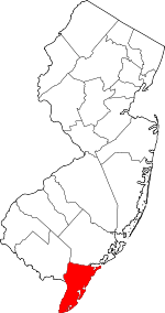 Map of New Jersey highlighting Cape May County | |
| Boroughs | ||
| Townships | ||
| CDPs | ||
| Other unincorporated communities | ||