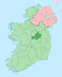
Churchtown, County Westmeath (civil parish)
Churchtown (Irish: Baile an Teampaill)[1] is a civil parish in County Westmeath, Ireland. It is located about 11.13 kilometres (7 mi) west–south–west of Mullingar.
Churchtown Baile an Teampaill | |
|---|---|
 Churchtown Location of Churchtown within County Westmeath in the Republic of Ireland | |
| Coordinates: 53°29′31″N 7°30′12″W | |
| Country | |
| Province | Leinster |
| County | County Westmeath |
| Irish grid reference | N330491 |
Churchtown is one of 9 civil parishes in the barony of Rathconrath in the Province of Leinster. The civil parish covers 5,301.6 acres (21.455 km2).
Churchtown civil parish comprises 16 townlands: Ballynafearagh, Balrath, Churchtown, Clontinteen, Coyne, Crissaun, Croughal, Dundonnell, Glomerstown, Jamestown, Milltown, Nicholastown, Rathcore, Redmondstown, Rogerstown and Taghboyne.
The neighbouring civil parishes are: Mullingar to the north–east, Dysart to the east, Castletownkindalento the south, Conry to the west and Rathconrath to the north–west.[1][2][3]
References
- Churchtown civil parish The Placenames Database of Ireland. Retrieved on 2 August 2015.
- Churchtown civil parish, Co. Westmeath townlands.ie Retrieved on 2 August 2015.
- Churchtown civil parish, Co. Westmeath The IreAtlas Townland Data Base. Retrieved on 2 August 2015.
External links
- Churchtown civil parish at the IreAtlas Townland Data Base
- Churchtown civil parish at townlands.ie
- Churchtown civil parish at The Placenames Database of Ireland
This article is issued from Wikipedia. The text is licensed under Creative Commons - Attribution - Sharealike. Additional terms may apply for the media files.