Loughnavalley
Louaghnavalley is a village in County Westmeath, Ireland. It is located at the crossroads of the R389 and the R390, to the west of Mullingar.[1][2]
Loughnavalley | |
|---|---|
Village | |
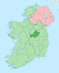
 Loughnavalley Location in Ireland | |
| Coordinates: 53°29′10″N 7°31′35″W | |
| Country | Ireland |
| Province | Leinster |
| County | County Westmeath |
| Time zone | UTC+0 (WET) |
| • Summer (DST) | UTC-1 (IST (WEST)) |
The Hill of Uisneach stands to the west of the town, near the village of Killare.[3]
The village features the Church of the Assumption, Catholic church, a national school and a bar.
References
- Parliament, Great Britain (1892). The Parliamentary Debates. R. Bagshaw.
- Dáil, Ireland Oireachtas (1929). Parliamentary debates; official report.
- "Loughnavalley, Mullingar, Co. Westmeath". Find Latitude and Longitude. Retrieved 2020-07-02.
This article is issued from Wikipedia. The text is licensed under Creative Commons - Attribution - Sharealike. Additional terms may apply for the media files.