Conry (civil parish)
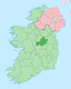
Conry (Irish: Cónra)[1] is a civil parish in County Westmeath, Ireland. It is located about 14.63 kilometres (9 mi) west–south–west of Mullingar.
Conry Cónra | |
|---|---|
 Conry Location of Conry within County Westmeath in the Republic of Ireland | |
| Coordinates: 53°28′43″N 7°33′5″W | |
| Country | |
| Province | Leinster |
| County | County Westmeath |
| Irish grid reference | N298476 |
Conry is one of 9 civil parishes in the barony of Rathconrath in the Province of Leinster. The civil parish covers 3,683.7 acres (14.907 km2).
Conry civil parish comprises the Hill of Uisneach and 13 townlands: Adamstown, Aghabrack, Carn, Clonownmore, Clonyrina, Gneevestown, Jamestown, Kellybrook, Lalistown, Lockardstown, Mweelra, Rathnew, Togherstown and Ushnagh Hill.
The neighbouring civil parishes are: Ballymorin and Rathconrath to the north, Churchtown to the east, Ardnurcher, or Horseleap and Castletownkindalen to the south and Killare to the west.[1][2][3]
References
- Conry civil parish The Placenames Database of Ireland Retrieved on 1 August 2015.
- Conry civil parish, Co. Westmeath townlands.ie Retrieved on 1 August 2015.
- Conry civil parish, Co. Westmeath The IreAtlas Townland Data Base. Retrieved on 1 August 2015.
External links
- Conry civil parish at the IreAtlas Townland Data Base
- Conry civil parish at townlands.ie
- Conry civil parish at The Placenames Database of Ireland
This article is issued from Wikipedia. The text is licensed under Creative Commons - Attribution - Sharealike. Additional terms may apply for the media files.