Dysart (civil parish)
Dysart (Irish: An Díseart, meaning "hermitage")[1] is a civil parish in County Westmeath, Ireland. It is located about 8.5 kilometres (5 mi) south‑west of Mullingar.
Dysart An Díseart | |
|---|---|
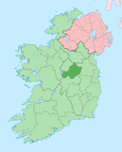
 Dysart Location of Dysart within County Westmeath in the Republic of Ireland | |
| Coordinates: 53°28′39″N 7°26′45″W | |
| Country | |
| Province | Leinster |
| County | County Westmeath |
| Irish grid reference | N369476 |
Dysart is one of 3 civil parishes in the barony of Moyashel and Magheradernon in the Province of Leinster. The civil parish covers 7,424.7 acres (30.047 km2). Parts of the parish (Ballyhandy and Barrettstown) are in the neighbouring barony of Rathconrath, others (Lilliput Nure and Monaghanstown) are in the barony of Moycashel.
Dysart civil parish comprises 11 townlands: Ballyhandy, Barrettstown, Bryanstown, Dysart, Lilliput Nure, Monaghanstown, Rathnamuddagh, Slane Beg and Yorkfield. The major part of Dysart is separated from two isolated townlands south of Lough Owel, Ballyote and Slane More.
The neighbouring civil parishes are: Mullingar to the north, Lynn (barony of Fartullagh) to the north‑east, Moylisker and Carrick (both Fartullagh) to the east, Clonfad (Fartullagh) to the south‑east, Castletownkindalen (barony of Moycashel) to the south and south‑west and Churchtown (barony of Rathconrath) to the west and north‑west.[2][3] This excludes neighbours of Ballyote and Slane More.
References
- Dysart civil parish The Placenames Database of Ireland. Retrieved on 15 June 2015.
- Dysart civil parish, Co. Westmeath townlands.ie Retrieved on 15 June 2015.
- Dysart civil parish, Co. Westmeath The IreAtlas Townland Data Base. Retrieved on 15 June 2015.
External links
- Dysart civil parish at the IreAtlas Townland Data Base
- Dysart civil parish at townlands.ie
- Dysart civil parish at The Placenames Database of Ireland