Chouteau County, Montana
Chouteau County is a county located in the North-Central region of the U.S. state of Montana. As of the 2010 United States Census, the population was 5,813.[1] Its county seat is Fort Benton.[2] The county was established in 1865 as one of the original nine counties of Montana, and named in 1882 after Pierre Chouteau Jr., a fur trader who established a trading post that became Fort Benton, which was once an important port on the Missouri River.
Chouteau County | |
|---|---|
 Chouteau County Courthouse in Fort Benton | |
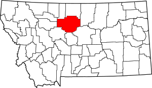 Location within the U.S. state of Montana | |
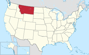 Montana's location within the U.S. | |
| Coordinates: 47°53′N 110°26′W | |
| Country | |
| State | |
| Founded | 1865 |
| Named for | Pierre Chouteau Jr. |
| Seat | Fort Benton |
| Largest city | Fort Benton |
| Area | |
| • Total | 3,997 sq mi (10,350 km2) |
| • Land | 3,972 sq mi (10,290 km2) |
| • Water | 24 sq mi (60 km2) 0.6% |
| Population (2010) | |
| • Total | 5,813 |
| • Estimate (2018) | 5,745 |
| • Density | 1.5/sq mi (0.56/km2) |
| Time zone | UTC−7 (Mountain) |
| • Summer (DST) | UTC−6 (MDT) |
| Congressional district | At-large |
| Website | www |
| |
Chouteau County is home to the Chippewa-Cree tribe on the Rocky Boy Indian Reservation. It contains part of the Lewis and Clark National Forest. Also, Chouteau County is the setting for much of the movie Legends of the Fall, based on the novella of the same name by Jim Harrison.
Geography
According to the US Census Bureau, the county has a total area of 3,997 square miles (10,350 km2), of which 3,972 square miles (10,290 km2) is land and 24 square miles (62 km2) (0.6%) is water.[3]
Chouteau County was once the largest county in the Montana Territory and the second largest in the United States, with an area of 15,439 square miles (39,990 km2) in the early 20th century. However, some parts of the county were over 250 miles (400 km) from Fort Benton, and in 1893, the first of several divisions began with the creation of Teton County, the western portion of Chouteau County. Chouteau County lost half of its population from 1910 to 1930.
The land is mostly prairie. The Bear Paw Mountains rise in the eastern section and the Little Rockies and the Highwood ranges are in the southern portion. Major rivers include the Teton River, Marias River, Missouri River and the Arrow River.
Adjacent counties
- Liberty County – north
- Hill County – north
- Blaine County – east
- Fergus County – southeast
- Judith Basin County – south
- Cascade County – south
- Teton County – west
- Pondera County – northwest
Major highway

National protected areas
Politics
| Year | Republican | Democratic | Third parties |
|---|---|---|---|
| 2016 | 64.5% 1,679 | 28.1% 732 | 7.4% 192 |
| 2012 | 62.3% 1,758 | 34.7% 978 | 3.0% 85 |
| 2008 | 57.1% 1,634 | 39.2% 1,122 | 3.7% 105 |
| 2004 | 65.5% 1,913 | 32.4% 946 | 2.1% 62 |
| 2000 | 70.7% 2,039 | 23.8% 686 | 5.5% 160 |
| 1996 | 52.6% 1,660 | 32.9% 1,039 | 14.5% 458 |
| 1992 | 42.7% 1,380 | 29.6% 959 | 27.7% 897 |
| 1988 | 61.5% 1,980 | 36.2% 1,166 | 2.3% 73 |
| 1984 | 72.2% 2,425 | 26.7% 896 | 1.2% 39 |
| 1980 | 68.3% 2,448 | 23.8% 853 | 7.9% 282 |
| 1976 | 52.4% 1,814 | 45.3% 1,568 | 2.4% 83 |
| 1972 | 59.6% 2,027 | 33.8% 1,149 | 6.6% 223 |
| 1968 | 53.7% 1,695 | 38.5% 1,216 | 7.9% 248 |
| 1964 | 44.1% 1,444 | 55.8% 1,827 | 0.2% 5 |
| 1960 | 49.3% 1,672 | 50.4% 1,708 | 0.3% 9 |
| 1956 | 49.0% 1,721 | 51.0% 1,794 | 0.0% 0 |
| 1952 | 59.4% 2,098 | 40.3% 1,423 | 0.4% 14 |
| 1948 | 37.6% 1,181 | 58.4% 1,832 | 4.0% 125 |
| 1944 | 38.7% 1,220 | 60.5% 1,906 | 0.9% 27 |
| 1940 | 35.5% 1,235 | 63.7% 2,213 | 0.8% 27 |
| 1936 | 24.0% 878 | 74.8% 2,734 | 1.2% 45 |
| 1932 | 35.4% 1,232 | 60.2% 2,093 | 4.4% 152 |
| 1928 | 59.1% 1,837 | 39.7% 1,232 | 1.2% 37 |
| 1924 | 46.2% 1,347 | 24.2% 706 | 29.7% 866 |
| 1920 | 60.9% 2,646 | 33.0% 1,436 | 6.1% 266 |
| 1916 | 33.6% 1,486 | 62.0% 2,738 | 4.4% 196 |
| 1912 | 41.4% 561 | 29.7% 402 | 28.9% 391 |
| 1908 | 54.7% 1,220 | 40.1% 893 | 5.2% 116 |
| 1904 | 70.6% 1,517 | 26.4% 568 | 2.9% 63 |
Demographics
| Historical population | |||
|---|---|---|---|
| Census | Pop. | %± | |
| 1870 | 517 | — | |
| 1880 | 3,068 | 493.4% | |
| 1890 | 4,741 | 54.5% | |
| 1900 | 10,966 | 131.3% | |
| 1910 | 17,191 | 56.8% | |
| 1920 | 11,051 | −35.7% | |
| 1930 | 8,635 | −21.9% | |
| 1940 | 7,316 | −15.3% | |
| 1950 | 6,974 | −4.7% | |
| 1960 | 7,348 | 5.4% | |
| 1970 | 6,473 | −11.9% | |
| 1980 | 6,092 | −5.9% | |
| 1990 | 5,452 | −10.5% | |
| 2000 | 5,970 | 9.5% | |
| 2010 | 5,813 | −2.6% | |
| Est. 2018 | 5,745 | [5] | −1.2% |
| US Decennial Census[6] 1790–1960[7] 1900–1990[8] 1990–2000[9] 2010–2018[1] | |||
2000 census
As of the 2000 United States Census,[10] there were 5,970 people, 2,226 households, and 1,613 families living in the county. The population density was 2 people per square mile (1/km²). There were 2,776 housing units at an average density of <1/km² (1/sq mi). The racial makeup of the county was 84.00% White, 0.08% Black or African American, 14.62% Native American, 0.23% Asian, 0.10% Pacific Islander, 0.23% from other races, and 0.72% from two or more races. 0.67% of the population were Hispanic or Latino of any race. 23.9% were of German, 11.7% Norwegian, 8.2% English and 7.3% Irish ancestry. 96.0% spoke English, 2.5% Cree and 1.0% Spanish as their first language.
There were 2,226 households out of which 34.00% had children under the age of 18 living with them, 60.90% were married couples living together, 8.40% had a female householder with no husband present, and 27.50% were non-families. 24.90% of all households were made up of individuals and 10.60% had someone living alone who was 65 years of age or older. The average household size was 2.59 and the average family size was 3.11.
The county population contained 28.80% under the age of 18, 6.50% from 18 to 24, 24.10% from 25 to 44, 23.10% from 45 to 64, and 17.50% who were 65 years of age or older. The median age was 39 years. For every 100 females there were 100.80 males. For every 100 females age 18 and over, there were 97.10 males.
The median income for a household in the county was $29,150, and the median income for a family was $32,399. Males had a median income of $22,080 versus $19,318 for females. The per capita income for the county was $14,851. About 16.50% of families and 20.50% of the population were below the poverty line, including 29.30% of those under age 18 and 8.40% of those age 65 or over.
2010 census
As of the 2010 United States Census, there were 5,813 people, 2,294 households, and 1,560 families living in the county.[11] The population density was 1.5 inhabitants per square mile (0.58/km2). There were 2,879 housing units at an average density of 0.7 per square mile (0.27/km2).[12] The racial makeup of the county was 75.8% white, 21.8% American Indian, 0.4% Asian, 0.1% Pacific islander, 0.1% black or African American, 0.3% from other races, and 1.6% from two or more races. Those of Hispanic or Latino origin made up 1.6% of the population.[11] In terms of ancestry, 27.6% were German, 13.0% were Irish, 11.2% were English, 9.8% were Norwegian, and 2.0% were American.[13]
Of the 2,294 households, 31.2% had children under the age of 18 living with them, 52.3% were married couples living together, 10.1% had a female householder with no husband present, 32.0% were non-families, and 29.1% of all households were made up of individuals. The average household size was 2.48 and the average family size was 3.04. The median age was 41.5 years.[11]
The median income for a household in the county was $41,064 and the median income for a family was $50,201. Males had a median income of $33,866 versus $25,077 for females. The per capita income for the county was $20,202. About 14.8% of families and 21.0% of the population were below the poverty line, including 33.6% of those under age 18 and 6.2% of those age 65 or over.[14]
Economy
Chouteau County is the state's largest winter wheat producer.[15] It is located in the heart of the "Golden Triangle", which produces about 45% of Montana's annual wheat crop.[16]

See also
| Wikimedia Commons has media related to Chouteau County, Montana. |
- List of cemeteries in Chouteau County, Montana
- List of lakes in Chouteau County, Montana
- List of mountains in Chouteau County, Montana
- National Register of Historic Places listings in Chouteau County, Montana
References
- "State & County QuickFacts". US Census Bureau. Archived from the original on July 8, 2011. Retrieved September 14, 2013.
- "Find a County". National Association of Counties. Archived from the original on May 3, 2015. Retrieved June 7, 2011.
- "2010 Census Gazetteer Files". US Census Bureau. August 22, 2012. Archived from the original on December 5, 2014. Retrieved November 27, 2014.
- Leip, David. "Atlas of US Presidential Elections". uselectionatlas.org. Retrieved April 2, 2018.
- "Population and Housing Unit Estimates". Retrieved August 5, 2019.
- "US Decennial Census". US Census Bureau. Retrieved November 27, 2014.
- "Historical Census Browser". University of Virginia Library. Retrieved November 27, 2014.
- "Population of Counties by Decennial Census: 1900 to 1990". US Census Bureau. Retrieved November 27, 2014.
- "Census 2000 PHC-T-4. Ranking Tables for Counties: 1990 and 2000" (PDF). US Census Bureau. Retrieved November 27, 2014.
- "U.S. Census website". US Census Bureau. Retrieved January 31, 2008.
- "Profile of General Population and Housing Characteristics: 2010 Demographic Profile Data". US Census Bureau]]. Archived from the original on February 13, 2020. Retrieved January 9, 2016.
- "Population, Housing Units, Area, and Density: 2010 – County". US Census Bureau. Archived from the original on February 13, 2020. Retrieved January 9, 2016.
- "Selected Social Characteristics in the US – 2006–2010 American Community Survey 5-Year Estimates". US Census Bureau]]. Archived from the original on February 13, 2020. Retrieved January 9, 2016.
- "Selected Economic Characteristics – 2006–2010 American Community Survey 5-Year Estimates". US Census Bureau. Archived from the original on February 13, 2020. Retrieved January 9, 2016.
- Merrill, Andrea; Judy Jacobson (1997). Montana almanac. Helena MT: Falcon Publishing. ISBN 1-56044-493-2.
- Wheat and Barley Committee. "The basics of wheat – and more!". Archived from the original on July 21, 2011. Retrieved July 23, 2011.
- Big Sag, Chouteau County MT Google Maps (accessed 1 January 2019)
- Coal Banks Landing, Chouteau County MT Google Maps (accessed 1 January 2019)
- Lippard, Chouteau County MT Google Maps (accessed 1 January 2019)
- Shepherd Crossing, Chouteau County MT Google Maps (accessed 1 January 2019)
- Shonkin, Chouteau County MT Google Maps (accessed 1 January 2019)
- Stranahan, Chouteau County MT Google Maps (accessed 1 January 2019)
- Virgelle, Chouteau County MT Google Maps (accessed 1 January 2019)
- Warrick, Chouteau County MT Google Maps (accessed 1 January 2019)
- Woods Crossing, Chouteau County MT Google Maps (accessed 1 January 2019)
External links
- "History of Chouteau County". Archived from the original on December 21, 2012. Retrieved February 23, 2007.
Places adjacent to Chouteau County, Montana | ||||||||||
|---|---|---|---|---|---|---|---|---|---|---|
| ||||||||||
Municipalities and communities of Chouteau County, Montana, United States | ||
|---|---|---|
| City | Chouteau County map | |
| Towns | ||
| CDPs | ||
| Unincorporated communities | ||
| Ghost town | ||
| Indian reservations |
| |
| Footnotes | ‡This populated place also has portions in an adjacent county or counties | |
| Authority control |
|
|---|