Bridge Creek, Oklahoma
Bridge Creek is a town in Grady County, Oklahoma, United States. As of the 2010 census, the town population was 336.[5]
Bridge Creek, Oklahoma | |
|---|---|
Town | |
 Bridge Creek  Bridge Creek | |
| Coordinates: 35°14′6″N 97°44′12″W[1] | |
| Country | United States |
| State | Oklahoma |
| County | Grady |
| Area | |
| • Total | 1.65 sq mi (4.27 km2) |
| • Land | 1.65 sq mi (4.27 km2) |
| • Water | 0.00 sq mi (0.00 km2) |
| Elevation | 1,378 ft (420 m) |
| Population (2010) | |
| • Total | 336 |
| • Estimate (2019)[3] | 336 |
| • Density | 203.64/sq mi (78.61/km2) |
| Time zone | UTC-6 (CST) |
| • Summer (DST) | UTC-5 (CDT) |
| ZIP code | 73010 / 73089[4] |
| Area code | 405 |
| FIPS code | 40-08725[1] |
| GNIS ID | 1934555[1] |
History
Bridge Creek was incorporated as a town in 2000.[6][7] The town proper and the unincorporated areas that its limits enclose are part of a rapidly growing area of northern McClain and Grady counties known as the "Tri-City Area" with Newcastle, Tuttle and Blanchard.[8]
Bridge Creek was one of several communities hardest hit by an F5 tornado in the deadly May 3, 1999, tornado outbreak. At least 12 died in the Bridge Creek area. Doppler radar measured wind speeds of 301 ± 20 mph (484 ± 32 km/h) in this tornado when it was near Bridge Creek. This is the highest wind speed ever recorded on Earth.[9]
The town was hit again by an EF3 tornado on May 6, 2015. 25 homes were destroyed or heavily damaged.[10][11]
Geography
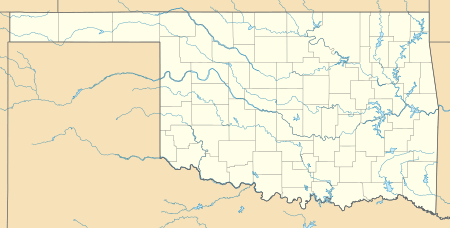
Bridge Creek is located in northeastern Grady County at 35°14′50″N 97°43′24″W (35.247350, −97.723460).[12] It is bordered to the north, west, and southwest by the city of Tuttle, to the south by the city of Blanchard, and to the east by the city of Newcastle in McClain County.
Interstate 44, the H. E. Bailey Turnpike, forms the southeast border of the town, leading northeast 25 miles (40 km) to downtown Oklahoma City and southwest 17 miles (27 km) to Chickasha, the Grady County seat. Oklahoma State Highway 4, the H. E. Bailey Turnpike Norman Spur, leads north through the center of Bridge Creek and continues north 11 miles (18 km) to Mustang.
According to the U.S. Census Bureau, the town of Bridge Creek has a total area of 1.6 square miles (4.2 km2), all of it land.[5]
Demographics
| Historical population | |||
|---|---|---|---|
| Census | Pop. | %± | |
| 2000 | 36 | — | |
| 2010 | 336 | 833.3% | |
| Est. 2019 | 336 | [3] | 0.0% |
| U.S. Decennial Census[13] | |||
References
- Geographic Names Information System (GNIS) details for Bridge Creek, Oklahoma. United States Geological Survey (August 22, 2001).
- "2019 U.S. Gazetteer Files". United States Census Bureau. Retrieved July 28, 2020.
- "Population and Housing Unit Estimates". United States Census Bureau. May 24, 2020. Retrieved May 27, 2020.
- United States Postal Service. "USPS – Look Up a ZIP Code".
- "Geographic Identifiers: 2010 Demographic Profile Data (G001): Bridge Creek town, Oklahoma". American Factfinder. U.S. Census Bureau. Retrieved January 26, 2017.
- "Map at Oklahoma Tax Commission website indicating municipal limits". tax.ok.gov. Archived from the original on 2009-04-17.
- "A website indicating incorporation in 2000".
- "Example of Bridge Creek's inclusion in colloquial "Tri-City Area"". rmtricity.com.
- "Top Ten Deadliest Oklahoma Tornadoes (1882–2008)". srh.noaa.gov. Archived from the original on 2008-06-18.CS1 maint: BOT: original-url status unknown (link)
- Gov. Mary Fallin Surveys Storm Damage In Bridge Creek. newson6.com (May 7, 2015). Retrieved on 2017-05-03.
- Tornado Outbreak Wreaks Havoc Across Great Plains; Multiple Injuries Reported. Weather Channel (May 7, 2015). Retrieved on 2017-05-03.
- "US Gazetteer files: 2010, 2000, and 1990". United States Census Bureau. 2011-02-12. Retrieved 2011-04-23.
- "Census of Population and Housing". Census.gov. Retrieved June 4, 2015.
External links
Municipalities and communities of Grady County, Oklahoma, United States | ||
|---|---|---|
| Cities | 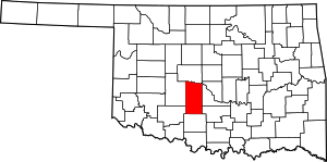 Grady County map | |
| Towns | ||
| Unincorporated communities | ||
| Ghost towns | ||
| Indian reservation | ||
| Footnotes | ‡This populated place also has portions in an adjacent county or counties | |