Amber, Oklahoma
Amber is a town in Grady County, Oklahoma, United States. The population was 419 at the 2010 census.[5]
Amber, Oklahoma | |
|---|---|
 Location of Amber, Oklahoma | |
| Coordinates: 35°9′35″N 97°52′44″W | |
| Country | United States |
| State | Oklahoma |
| County | Grady |
| Area | |
| • Total | 3.96 sq mi (10.27 km2) |
| • Land | 3.96 sq mi (10.27 km2) |
| • Water | 0.00 sq mi (0.00 km2) |
| Elevation | 1,257 ft (383 m) |
| Population (2010) | |
| • Total | 419 |
| • Estimate (2019)[2] | 480 |
| • Density | 121.06/sq mi (46.74/km2) |
| Time zone | UTC-6 (Central (CST)) |
| • Summer (DST) | UTC-5 (CDT) |
| ZIP code | 73004 |
| Area code(s) | 405 |
| FIPS code | 40-01900[3] |
| GNIS feature ID | 1089607[4] |
Geography
Amber is located at 35°9′35″N 97°52′44″W (35.159613, -97.878766).[6]
According to the United States Census Bureau, the town has a total area of 4.0 square miles (10 km2), all of it land. The Post Office was established in 1903.
Demographics
| Historical population | |||
|---|---|---|---|
| Census | Pop. | %± | |
| 1980 | 416 | — | |
| 1990 | 418 | 0.5% | |
| 2000 | 490 | 17.2% | |
| 2010 | 419 | −14.5% | |
| Est. 2019 | 480 | [2] | 14.6% |
| U.S. Decennial Census[7] | |||
As of the census of 2010, there were 419 people living in the town.[5] The population density was 110 people per square mile (41/km2). There were 177 housing units at an average density of 45 per square mile (17/km2).[5] The racial makeup of the town was 89.18% White, 0.20% African American, 4.90% Native American, 1.22% Pacific Islander, 0.20% from other races, and 4.29% from two or more races. Hispanic or Latino of any race were 2.04% of the population.
There were 160 households, out of which 47.5% had children under the age of 18 living with them, 74.4% were married couples living together, 7.5% had a female householder with no husband present, and 16.9% were non-families. 15.6% of all households were made up of individuals, and 5.0% had someone living alone who was 65 years of age or older. The average household size was 3.06 and the average family size was 3.34.
In the town, the population was spread out, with 34.9% under the age of 18, 6.9% from 18 to 24, 29.8% from 25 to 44, 20.0% from 45 to 64, and 8.4% who were 65 years of age or older. The median age was 29 years. For every 100 females, there were 96.8 males. For every 100 females age 18 and over, there were 95.7 males.
The median income for a household in the town was $32,083, and the median income for a family was $34,688. Males had a median income of $24,531 versus $20,375 for females. The per capita income for the town was $12,012. About 9.7% of families and 10.8% of the population were below the poverty line, including 9.2% of those under age 18 and 22.2% of those age 65 or over.
Amber is also the home of Amber-Pocasset Jr. Sr. High School, home of the Panthers.
References
- "2019 U.S. Gazetteer Files". United States Census Bureau. Retrieved July 28, 2020.
- "Population and Housing Unit Estimates". United States Census Bureau. May 24, 2020. Retrieved May 27, 2020.
- "U.S. Census website". United States Census Bureau. Retrieved 2008-01-31.
- "US Board on Geographic Names". United States Geological Survey. 2007-10-25. Retrieved 2008-01-31.
- "2010 City Population and Housing Occupancy Status". U.S. Census Bureau. Retrieved October 18, 2013.
- "US Gazetteer files: 2010, 2000, and 1990". United States Census Bureau. 2011-02-12. Retrieved 2011-04-23.
- "Census of Population and Housing". Census.gov. Retrieved June 4, 2015.
External links
Municipalities and communities of Grady County, Oklahoma, United States | ||
|---|---|---|
| Cities | 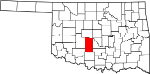 Grady County map | |
| Towns | ||
| Unincorporated communities | ||
| Ghost towns | ||
| Indian reservation | ||
| Footnotes | ‡This populated place also has portions in an adjacent county or counties | |