Bijnor district
Bijnor district is one of the 75 districts in the state of Uttar Pradesh in India. Bijnor city is the district headquarters. The government of Uttar Pradesh seeks it to be included in National Capital Region (NCR) due to its close proximity to NCT of Delhi.[1]
Bijnor district | |
|---|---|
District of Uttar Pradesh | |
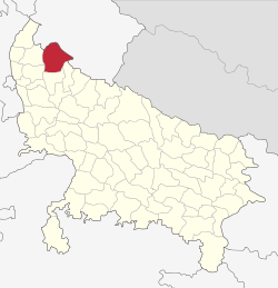 Location of Bijnor district in Uttar Pradesh | |
| Country | India |
| State | Uttar Pradesh |
| Division | Moradabad |
| Headquarters | Bijnor |
| Area | |
| • Total | 4,049 km2 (1,563 sq mi) |
| Population (2011) | |
| • Total | 3,682,713 |
| • Density | 910/km2 (2,400/sq mi) |
| Time zone | UTC+05:30 (IST) |
| Website | http://bijnor.nic.in/ |
Geography
Bijnor, or more correctly Bijnaur, occupies the north-west corner of the Moradabad Division (historically, Rohilkhand or Bareilly region) and is a roughly triangular stretch of country with its apex to the north. The western boundary is formed throughout by the deep stream of the river Ganges, beyond which lie the four districts of Dehradun, Saharanpur, Muzaffarnagar, and Meerut. To the north and north-east in the hill country of Garhwal, the dividing line being the submontane road, which runs from Haridwar along the foot of the Himalayas to Ramanagar, Haldwani, and Tanakpur. This road, popularly known as the Kandi Saradk, belongs throughout its length to Garhwal, the transfer having taken place a few years since. On the east the Phika river for the greater part of its course constitutes the boundary, separating this district from Nainital and Moradabad, as far as its junction with the Ramganga; and to the south lie the Thakurdwara Tehsil of Moradabad. Amroha and Hasanpur tahsils of Amroha District. The boundary being conventional and undetermined by natural features. The extreme parallels of north latitude are 29° 2' and 29° 58' and of east longitude 78° 0' and 78° 57' from Lalitpur, the most northerly point, to koti Rao in the furthest eastern corner the distance in 56 miles (90 km); and from Koti Rao to Kamharia in the south-westerly angle 57 miles (92 km); and from Kamharia to Lalitpur 62 miles (100 km). The total area of the district is liable to change slightly from time to time by reason of the erratic action of the Ganges and Ramganga: In 1906 it amounted to 1,145,272 acres (1789.5 square miles, 4634.75 km²) the average for the last five years being 1,147,967 acres (4,645.66 km²).
There remains the low fringe of Khadir along the Ganges to the west. This generally resembles the lowlands that skirt the rivers of the interior, the low flats which adjoin the stream itself being purely alluvial in character, while above them rises a terrace of higher ground extending inland as far as the chain of stagnant morasses lying immediately under the bangar cliff.
Divisions
Politics
The MP of Bijnor is Malook Nagar. He represents Bahujan Samaj Party.
Demographics
| Year | Pop. | ±% p.a. |
|---|---|---|
| 1901 | 776,308 | — |
| 1911 | 802,166 | +0.33% |
| 1921 | 736,765 | −0.85% |
| 1931 | 831,403 | +1.22% |
| 1941 | 905,793 | +0.86% |
| 1951 | 979,406 | +0.78% |
| 1961 | 1,184,306 | +1.92% |
| 1971 | 1,480,734 | +2.26% |
| 1981 | 1,927,023 | +2.67% |
| 1991 | 2,454,521 | +2.45% |
| 2001 | 3,131,619 | +2.47% |
| 2011 | 3,682,713 | +1.63% |
| source:[2] | ||
According to the 2011 census Bijnor district has a population of 3,682,713,[3] roughly equal to the nation of Liberia[4] or the US state of Oklahoma.[5] This gives it a ranking of 74th in India (out of a total of 640).[3] The district has a population density of 808 inhabitants per square kilometre (2,090/sq mi) .[3] Its population growth rate over the decade 2001-2011 was 17.64%.[3] Bijnor has a sex ratio of 913 females for every 1000 males,[3] and a literacy rate of 70.43%.[3]
Religion
Kanva Ashram an ashram in dilapidated condition near Rawli town according to the great legend "Abhigyan Shakuntalam". Hastinapur's King Dushyant reached there while hunting and fell in love with Shakuntala at first sight. Ganj is about 12 km from District HQ and just 1 km from Daranagar on the banks of the Ganges. There are ancient temples and ashrams. Jahanabad is situated on the bank of river Ganges and just about 1 km from Ganj. This village used to be a riyasat with around 101 villages under it during Mughal Period. Around that period a saint was living there who was famous for curing snake bites. Once when Shahjahan's wife got bit by a snake, he treated and got "Jahanabad Riyasat" as a prize from Shah Jahan. Presently the Ganges flows 2 km from here. Sita's temple without any idol is situated one km from Nanore Village on Chandpur-Jalilpur road. This is popularly known as "Sita Mandir Math". It is believed that this is the place where the earth tore and Sita jumped into. Sena Ka Dawar means Army's Gate where Pandavas had settled their Army. There is a temple of Dronacharya presently. This place is popularly known as a village Saindwar where Jawahar Navodaya Vidyalaya is established. Bakharpur Garhi village is situated on the bank of the Malan river and known for its ancient Gogaji temple. The village is about 5 km from District HQ. Every year, Gogaji's fair is organized in the second week of Shravan month.
Culture
Agriculture is the main source of income in Bijnor, with sugarcane being the main crop.
Tourism
Vidur Kuti is about 10 km from Bijnor and has historical importance. Mahatma Vidur spent all of his life. This is the place where Lord Krishana visited and eat Bathue ka Saag. During Mahabharat when the battle between Kauravas and Pandavas was about to begin, then on the request of both sides, all wives and children were to be guardianed by Mahatma Vidur. He had no sufficient space for their living then he decided an exclusive area for ladies and children, which is now known as Daranagar.
One place is popularly known as a village Saindwar from where the Pandavas army stayed and started for Panipat to fight the battle of Mahabharat. Jawahar Navodaya Vidyalaya is also established here. Two of the Akbar's Navratnas, namely Abul Fazzal and his brother Faizi, were born in the village Azampur which is 4 km from Basta. The town of Basta is surrounded by 62 villages and the Hindi word for 62 is बासठ, that's why it is called as Basta. They studied in this village and were very intelligent. Najibudaulah's Fort is situated in Najibabad which is also known as Sultana Daku ka Kila (Fort of Sultana Dakait). This fort was built by "Gulam Kadir" alias "Najibudaulah" during the 18th century after the downfall of the Mughal Empire.
Settlements
- Bijnor city
- Jhalu town
- Mandawar town
- Chandok
- Nagina city
- Sherkot city
- Najibabad city
- Chandpur city
- Ratangarh village
- Dhampur city
- Noorpur city
- Seohara city
- Bahupura village
- Haldaur city
- Umri village
- Harewali village
- Shahzadpur village
- Tajpur town/ village
- Basi Kiratpur
- Sahanpur village
- Nehtaur
- Ranipur, Uttar Pradesh
- Afzalgarh city
- Askaripur village
- Linderpur village
- Mandawali village
- Basera Kunwar village
- Pakhanpur village
- Sahaspur town
References
- "UP seeks to include 6 districts in NCR". indianexpress.com. 11 January 2015. Retrieved 18 March 2018.
- Decadal Variation In Population Since 1901
- "District in Uttar Pradesh". www.citypopulation.de. 2019. Retrieved 19 June 2019.
- US Directorate of Intelligence. "Country Comparison:Population". Retrieved 1 October 2011.
Liberia 3,786,764 July 2011 est.
- "2010 Resident Population Data". U. S. Census Bureau. Archived from the original on 1 January 2011. Retrieved 30 September 2011.
Oklahoma 3,751,351
- "Bijnor Religion Census 2011". Office of the Registrar General and Census Commissioner, India. Retrieved 16 November 2015.
- "52nd Report of the Commissioner for Linguistic Minorities in India" (PDF). nclm.nic.in. Ministry of Minority Affairs. Archived from the original (PDF) on 25 May 2017. Retrieved 29 April 2019.
- "C-16 Population By Mother Tongue - Uttar Pradesh". censusindia.gov.in. Retrieved 23 September 2019.
External links
| Wikimedia Commons has media related to Bijnor district. |
Places adjacent to Bijnor district | ||||||||||
|---|---|---|---|---|---|---|---|---|---|---|
| ||||||||||