August 2020 Midwest derecho
The August 2020 Midwest derecho, a type of straight-line wind storm, was a severe weather event which took place from August 10-11, 2020 across the Midwestern United States. Moderate to severe damage occurred across the affected area, with the greatest damage occurring in Iowa and northern Illinois where the highest wind speeds were recorded. Wind speeds of 70 miles per hour (110 kilometres per hour; 31 metres per second) were prevalent across much of the affected area, with maximum recorded wind gusts of 112 mph (180 km/h; 50.1 m/s). The impact subjected millions to utility disruptions, residential and commercial property damage, and significant damage to the yearly corn crop in the area.
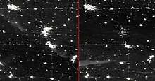
| Radar track from 2am Aug 10 to 4pm Aug 11 CDT | |
| Date(s) | August 10–11, 2020 |
|---|---|
| Duration | 14 hours[1] |
| Track length | 770 miles (1,240 km)[1] |
| Peak wind gust | 112 mph (180 km/h; 50.1 m/s) mph (Midway, Iowa[2]) |
| Tornadoes caused | 17 |
| Maximum rated tornado1 | EF1 tornado |
| Fatalities | 4 |
| Types of Damage | Widespread damage to residential and commercial property, agriculture, and public utility infrastructure, some severe, affecting millions in the affected areas. |
| Areas affected | South Dakota (SE), Iowa, Nebraska (NE), Wisconsin, Missouri, Illinois, Indiana (N), Michigan, Kentucky, Ohio |
| 1Most severe tornado damage; see Enhanced Fujita scale | |
Overview
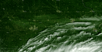
Beginning in the early morning, the event storm system developed in southeastern South Dakota and moved east into Iowa, followed by the southern Great Lakes region.[3][4][5][1][6] At peak, the wind gusts matched the sustained winds of a major hurricane, as such, the storm damage is more akin to that of a hurricane than a tornado.[3] Significant damage to homes, businesses, trees, and power lines occurred in the Des Moines, Cedar Rapids, and Chicago metro areas as a result of destructive straight-line winds. Numerous small to mid-sized towns also sustained major damage as well. The peak of the derecho occurred as the storm system pushed into central Iowa, losing strength after passing through Illinois.[5][7] Winds 60 mph (97 km/h; 27 m/s) or faster sustained for nearly half an hour in some places.[7] Illinois and Indiana had 17 confirmed tornadoes as a result of circulations embedded within the derecho, all of which were rated EF0 to EF1.[8]
The storm prompted widespread severe thunderstorm warnings, tornado warnings, and high wind warnings, the latter of which are issued when sustained winds of 40–73 mph (64–120 km/h; 18–33 m/s) are expected.
Many affected towns and cities advised residents not to travel due to damage. Many city-wide and county-wide states of emergency were declared.[9] On August 13, Iowa Governor Kim Reynolds issued a state-level disaster proclamation for 23 of Iowa's 99 counties.[10]
Impact
Power and telecommunication outages
Wide-scale utility disruption and property damage occurred across the affected area. Early estimates showed more than a million customers (residential and commercial) have been left without power.[3][11][12][10][13] As of Thursday, August 13, affected customers totaled over 1.9 million, with 1.4 million maximum simultaneous outages, breaking down into 759,000 in Illinois, 585,000 in Iowa, 283,000 in Indiana, and 345,000 in other states.[14][15] Over 100,000 Illinois and 200,000 Iowa customers were still without power on August 13.[10] Mediacom, a telecommunications company, has reported an internet outage for 340,000 customers across multiple states in the affected area.[4][16]
In the Des Moines metropolitan area, over 132,000 experienced outages according to local utility company Mid-American Energy. The company says it may take days of round-the-clock shifts before power is restored to many of them.[17][18][19]
Linn County, Iowa peaked at over 95% power loss to residents due to infrastructure damage.[4] Cedar Rapids, the county seat of Linn County, experienced a maximum of 98% of the city without power; as a result, about 100 members of the Iowa National Guard were activated to assist utility crews.[20][21]
In Omaha, Nebraska, over 50,000 were left without power.[3][22]
Terry Dusky, CEO of electrical infrastructure company ITC Midwest, described the storm damage as "...equivalent of a 40-mile wide tornado that rolled over 100 miles of the state."[23]
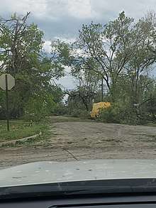
Extensive and severe wind damage to buildings, trees and vehicles
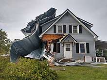
The storm's winds caused wide-scale damage to plants, particularly trees, snapping large limbs, ripping off branches, and even felling or uprooting whole trees, often damaging homes and vehicles, as well as electrical and telecommunications infrastructure. Homes sustained significant damage to roofs, windows, and siding. Businesses and manufacturing facilities also sustained major structural damage from the storm.[3][4][5][7][17] Large vehicles (such as semi-trailer trucks and recreational vehicles) as well as mobile homes were blown over, sent flying, or destroyed.[4][11][17]
Nebraska
In Eastern Nebraska near Tekamah and Fremont, some of earliest storm damage occurred. The National Weather Service issued a warning at 8:45 AM, with Omaha reporting its first damage just eight minutes later. Winds reached 67 mph, trees were downed, and at least one person was injured.[24]
Iowa
Marshalltown, Iowa suffered extensive property damage. Over a hundred cars parked near a factory had their windows blown out. Reports described 99 mph winds, roofs being ripped off, and loose wood debris being embedded into the side of buildings.[11][25][26]
The Des Moines Buccaneers's ice hockey arena sustained significant roof damage.[11][17]
The city of Ankeny, Iowa, part of the Des Moines metropolitan area, said it would take an estimated four-to-six weeks to fully clean up debris.[27] A Hy-Vee grocery store in Ankeny was found by the Iowa Department of Natural Resources to have illegally dumped 800 US gallons (3,000 L) of spoiled milk into storm sewers, contaminating a local waterway. The milk spoiled due to storm-related loss of power and thus refrigeration.[28]
Several major roads in Iowa City were closed due to storm debris, including Interstate 380 between Iowa City and Cedar Rapids.[29]
In Cedar Rapids, one of the hardest hit cities, Adjutant General Benjamin Corell, Commander of the Iowa National Guard, compared the extensiveness of the damage to Hurricane Katrina.[30] Cedar Rapids officials described the damage as being worse than the 2008 Iowa Flood.[20] The majority of all residential and commercial buildings were damaged, as well as twenty schools, resulting in the closure of most local businesses. Thousands of trees were downed throughout all 75 square miles of Cedar Rapids, and most of the city's roads became impassible. Trash pickup stopped, cell phone service was spotty, and many gas leaks were reported. Hospitals treated over 300 patients for storm related injuries. Initial professional estimates suggest that cleanup and removal of the city's downed trees could take months. Arborists have urged residents not to clear trees on their own, in order to avoid injury.[31][21][32][33]
Both Cedar Rapids and Marion, Iowa lost an estimated half or more of their tree canopy in the storm.[34]
Agricultural damage
Many farmers in Iowa, a major agricultural state and top corn producer in the US, found their crops flattened or agricultural infrastructure (e.g. silos, grain bins, grain elevators) imploded by the storm[4][11][10][17][35] Total area of damaged crops are currently estimated around 10 million acres (40,500 km2) in Iowa alone, which is approximately 43% of the 21.3 million acres (86,200 km2) of corn and soybeans planted in 2020 or a little more than a third of the state's total 30.6 million acres (124,000 km2) of arable land.[4][10][35][36][37] The crop damage is widespread enough to be seen from space satellite imagery.[35]
The average projected yield for the state has gone from 202 US bushels per acre (1,760 m3/km2) to 100–150 US bushels per acre (871–1,310 m3/km2), a reduction of up to half.[37] Prescient Weather CEO Jan Dutton estimated 180–270 million US bushels (6.34–9.51 million cubic metres) destroyed or degraded by the storm, however saying the damage is minor compared to the total US yearly agricultural production amounts which are in the tens of billions of bushels.[35]
Confirmed fatalities
Indiana
In Fort Wayne, a woman was killed when high winds tipped over her mobile home.[38]
Iowa
Poweshiek County Emergency Management confirmed the deaths of two, one Malcom woman in her 40s killed when a tree fell on her porch and one Brooklyn man in his 40s, a city employee and electrician, killed by electrocution from a downed power line he was attempting to repair.[39][23]
The Linn County Sheriff's Office confirmed a 63 year-old man who died from a falling tree while biking.[39]
Responses
Vice President Mike Pence held two campaign rallies in Iowa on Thursday, August 13. He promised to help Iowa rebuild, but did not tour areas damaged by the storm.[30]
Iowa Governor Kim Reynolds arrived in Cedar Rapids, Iowa with the National Guard on Friday, August 14. When asked about her delay in visiting the area, she explained that it was up to local officials to request disaster assistance.[30]
Lack of coverage and response
Local newsrooms, having suffered from downsizing and the impacts of the current pandemic, have been hard pressed to provide reporting under disaster conditions. As a result, national news coverage of storm impacts has been limited.[40]
Ashton Kutcher, originally from Cedar Rapids, Iowa, criticized the lack of federal response and aid for the storm, calling on Vice President Mike Pence, followed by President Donald Trump, to act to aid the affected areas.[41][42]
Official notices and records
Official NWS watches
Starting in the early morning of August 10, the National Weather Service tracked and published a series of watch bulletins for the event storm system. This tracking continued as the storm did throughout the day and into August 11.
| Bulletin # | Issued (CDT) | Type | Covered areas | Storm location | Storm heading | Watch details | |
|---|---|---|---|---|---|---|---|
| 424 | 6:05am (until 11:00am) | STW | South Dakota (SE), Nebraska (NE), Iowa (NW) | South Dakota-Nebraska border area | East (into eastern Iowa) | High Winds (75mph+) and Hail | [43] |
| 425 | 8:55am (until 2:00am) | STW | Iowa (most of state) | Iowa-Nebraska-South Dakota border area | East (into central Iowa) | High Winds (80mph+) and Large Hail | [44] |
| 426 | 11:25am (until 7pm) | STW | Iowa (E), Illinois (N), Wisconsin (S) | Iowa (central) | East (toward Lake Michigan) | Extreme Winds (100mph+), Large Hail and Isolated Tornadoes | [45] |
| 427 | 1pm (until 7pm) | STW | Wisconsin (E), Michigan (Upper Peninsula) | Iowa-Illinois border area | East (spreading north toward Lake Michigan) | High Winds (70mph+) and Large Hail | [46] |
| 428 | 4:25pm (until 12am) | STW | Michigan (S), Indiana (N) | Illinois (N) | East (toward Indiana) | High Winds (70mph+) and Large Hail | [47] |
| 429 | 2:55pm (until 10pm) | STW | Illinois, Missouri (E) | Iowa-Illinois border area, East Illinois | East (spreading south toward southern Illinois) | High Winds (80mph+) and Large Hail | [48] |
| 430 | 6:30pm (until 12am) | STW | Illinois (S), Indiana (S), Kentucky (NW) | Illinois (central), Indiana (central), Missouri (E) | Southeast (spreading toward Kentucky) | High Winds (70mph+) and Significant Hail | [49] |
| 431 | 7:05pm (until 12am)[lower-roman 1] | STW | Ohio (E) | Indiana, Michigan, Illinois (S) | East (Ohio) | High Winds (70mph+) and Significant Hail | [50] |
- Posted by National Weather Service in Eastern Daylight Time (EDT), converted for consistency
Highest recorded winds
| Recording Location | Peak Wind Gust Speed | Recorded By | |
|---|---|---|---|
| Midway, Iowa[lower-roman 1] | 112 mph (180 km/h; 50 m/s) | [7][12] | |
| Le Grand, Iowa[lower-roman 1] | 106 mph (171 km/h; 47 m/s) | Mesonet - Personal Station | [51][7][12] |
| Forreston, Illinois | 100 mph (160 km/h; 45 m/s)[lower-roman 2] | NWS Storm Survey | [52] |
| Hiawatha, Iowa[lower-roman 1] | 100 mph (160 km/h; 45 m/s) | [7][12] | |
| Marshalltown, Iowa (Airport) | 99 mph (159 km/h; 44 m/s) | ASOS | [51][12] |
| Albion, Iowa[lower-roman 1] | 99 mph (159 km/h; 44 m/s) | [7][12] | |
| Marshalltown, Iowa | 90–95 mph (145–153 km/h; 40–42 m/s)[lower-roman 2] | Iowa DOT, Storm spotter, Storm chaser | [51][7][12] |
| Glen Ellyn, Illinois | 90 mph (140 km/h; 40 m/s)[lower-roman 2] | NWS Storm Survey | [52] |
| Harvey, Illinois[lower-roman 1] | 90 mph (140 km/h; 40 m/s)[lower-roman 2] | NWS Storm Survey | [52] |
| Ottawa, Illinois | 90 mph (140 km/h; 40 m/s)[lower-roman 2] | NWS Storm Survey | [52] |
| Dixon, Illinois[lower-roman 1] | 92 mph (148 km/h; 41 m/s) | Mesonet - Personal Station | [52][7] |
| Cedar Point, Illinois[lower-roman 1] | 91 mph (146 km/h; 41 m/s) | Storm spotter | [13] |
| Atkins, Iowa | 90 mph (140 km/h; 40 m/s) | [12] | |
| Blairstown, Iowa | 90 mph (140 km/h; 40 m/s) | [12] | |
| Davenport, Iowa | 86 mph (138 km/h; 38 m/s) | [12] | |
| Chicago (Lincoln Square) | 85 mph (137 km/h; 38 m/s) | Mesonet - Personal Station | [52] |
| Neal Smith National Wildlife Refuge | 85 mph (137 km/h; 38 m/s) | RAWS | [51] |
| Urbandale, Iowa | 85 mph (137 km/h; 38 m/s) | Mesonet - Personal Station | [51][7] |
| Elkhart, Iowa[lower-roman 1] | 85 mph (137 km/h; 38 m/s) | Mesonet - Personal Station | [51] |
| Moline, Illinois[lower-roman 1] | 85 mph (137 km/h; 38 m/s) | Iowa DOT | [53][12] |
| Plainfield, Illinois[lower-roman 1] | 84 mph (135 km/h; 38 m/s) | Mesonet - Personal Station | [52] |
| Mendota, Illinois | 80 mph (130 km/h; 36 m/s)[lower-roman 2] | NWS Employee | [52] |
| South Pekin, Illinois | 80 mph (130 km/h; 36 m/s) | [13] | |
| Colfax, Iowa | 80 mph (130 km/h; 36 m/s)[lower-roman 2] | General Public | [51] |
| Quad Cities (Airport) | 79 mph (127 km/h; 35 m/s) | ASOS | [53] |
| Ankeny, IA (Airport) | 78 mph (126 km/h; 35 m/s) | AWOS | [51][12] |
| Hubbard, Iowa | 77 mph (120 km/h; 34 m/s) | CWOP | [51] |
| Des Moines, IA (Airport) | 75–80 mph (120–130 km/h; 34–36 m/s)[lower-roman 2] | ASOS, Storm spotter | [51][7][12] |
| Lee, Illinois | 75 mph (120 km/h; 34 m/s)[lower-roman 2] | Storm spotter | [52] |
| Leighton, Iowa | 75 mph (120 km/h; 34 m/s) | Mesonet - Personal Station | [51] |
| Kentland, Indiana[lower-roman 1] | 73 mph (120 km/h; 33 m/s) | Mesonet - Personal Station | [52] |
| Chicago (Midway) | 72.5 mph (117 km/h; 32.4 m/s) | [7] | |
| Cedar Rapids, Iowa (Airport) | 68 mph (109 km/h; 30 m/s) | ASOS | [53] |
| Spring Bay, Illinois | 65 mph (105 km/h; 29 m/s) | [13] | |
| Morton, Illinois | 65 mph (105 km/h; 29 m/s) | [13] | |
| Bloomington, Illinois | 64 mph (103 km/h; 29 m/s) | [13] | |
| Chicago (O'Hare) | 62 mph (100 km/h; 28 m/s) | [7] |
- Close nearby the town, but not within city limits.
- Wind speed estimated by non-instrument sources.
Confirmed tornadoes
| EFU | EF0 | EF1 | EF2 | EF3 | EF4 | EF5 | Total |
|---|---|---|---|---|---|---|---|
| 0 | 7 | 10 | 0 | 0 | 0 | 0 | 17 |
August 10 event
| EF# | Location | County / Parish | State | Start Coord. | Time (UTC) | Path length | Max width | Summary |
|---|---|---|---|---|---|---|---|---|
| EF0 | SSW of Burton | Grant | WI | 42.694°N 90.8312°W | 17:32–17:34 | 0.55 mi (0.89 km) | 50 yd (46 m) | A high-end EF0 tornado damaged two outbuildings, power lines, and hardwood trees.[54][55] |
| EF0 | Western Rockford | Winnebago | IL | 42.250°N 89.132°W | 19:37-19:38 | 1.5 mi (2.4 km) | 50 yd (46 m) | First of two tornadoes to strike Rockford. Some trees were damaged along the path.[56][57] |
| EF1 | Northeastern Rockford to Caledonia | Winnebago, Boone | IL | 42.280°N 89.021°W | 19:47-20:05 | 9.2 mi (14.8 km) | 300 yd (270 m) | Second of two tornadoes to strike Rockford. Trees and tree limbs were downed in the northeastern part of Rockford, with significant tree damage occurred in a localized area just east of Rock Valley College. Homes, apartment buildings, and businesses sustained roof, siding, and shingle damage. Two utility poles were snapped as well, and tree limbs were downed in Caledonia before the tornado dissipated.[56][58][55] |
| EF0 | N of Kirkland | DeKalb | IL | 42.1096°N 88.8676°W | 19:54-19:57 | 3.1572 mi (5.0810 km) | 40 yd (37 m) | A utility pole was snapped and a convergent pattern was left in corn fields.[55] |
| EF1 | Ottawa | LaSalle | IL | 41.353°N 88.844°W | 19:59-20:01 | 0.75 mi (1.21 km) | 150 yd (140 m) | This high-end EF1 tornado ripped well-anchored roofing material off of businesses in town, and snapped a power pole was at its base. Shingles were ripped off of homes and businesses just west of IL 23. Trees were shredded as well.[59][55][60] |
| EF1 | SE of Marengo | McHenry | IL | 42.182°N 88.654°W | 20:05-20:11 | 5.7 mi (9.2 km) | 200 yd (180 m) | Mainly tree damage occurred, although one single family home was heavily damaged.[56][61] |
| EF1 | Southern Yorkville to Plainfield | Kendall, Will | IL | 41.620°N 88.453°W | 20:15-20:30 | 14.5 mi (23.3 km) | 250 yd (230 m) | As the tornado touched down on the far southern side of Yorkville, it destroyed a pergola, ripped siding off a house, and threw fencing and parts of a tree over a roadway. Trees were also damaged as the tornado crossed IL 126. The tornado reached peak intensity as it mangled trees, destroyed a farm building, and bent a large grain bin inward. Wood panels thrown by the tornado left scour marks in the ground. Six power poles were snapped, and a 1,000–1,500 lb (450–680 kg) auger was moved 50 ft (15 m). The tornado then weakened as it entered Plainfield, causing tree, fence, and siding damage. The tornado lifted just before reaching I-55, although damaging winds of up to 82 miles per hour (132 km/h) continued to damage trees and roofs into the Crest Hill community.[59][55][62] |
| EF1 | Wheaton | DuPage | IL | 41.867°N 88.103°W | 20:35-20:36 | 0.3 mi (0.48 km) | 200 yd (180 m) | A 50 ft (15 m) tall church steeple was knocked down, by this short-lived, low-end EF1 tornado. Trees were also damaged nearby on the campus of Wheaton College. Damaging winds of up to 90 miles per hour (140 km/h) caused damage in nearby Glen Ellyn after the tornado dissipated.[56][63][55] |
| EF0 | Lake Geneva | Walworth | WI | 42.5568°N 88.4463°W | 20:38-20:42 | 3.3 mi (5.3 km) | 50 yd (46 m) | Large limbs and tree trunks were knocked down or snapped and house sustained minor damage in a residential area before the tornado reached its peak intensity as it crossed WS 120. Numerous trees were snapped, a building sustained roof and siding damage, and a car was splattered with debris. The tornado then quickly weakened and dissipated after crossing over US 12.[64][55] |
| EF1 | SSW of Camp Lake, WI | Lake (IL), Kenosha (WI) | IL, WI | 42.475°N 88.1895°W | 20:41-20:48 | 3.75 mi (6.04 km) | 150 yd (140 m) | In Illinois, the tornado damaged the roofs of homes, snapped or uprooted trees, and wrapped metal roofing from outbuildings around trees. The tornado weakened as it entered Wisconsin, where additional tree damage occurred and multiple homes sustained shingle and siding damage in the Camp Lake area.[64][55] |
| EF0 | Park Forest | Will, Cook | IL | 41.469°N 87.701°W | 20:57-20:59 | 2 mi (3.2 km) | 350 yd (320 m) | This high-end EF0 tornado caused mainly tree damage, including one tree that fell on a house.[59][55][65] |
| EF1 | Lincolnwood to Rogers Park | Cook | IL | 42.011°N 87.716°W | 20:59-21:04 | 3 mi (4.8 km) | 300 yd (270 m) | A high-end EF1 tornado was caught on video lofting debris as it moved through the Rogers Park neighborhood in Chicago. Trees were snapped or uprooted, a metal light post was snapped at its base, wooden power poles were left leaning, and some buildings sustained roof damage. The tornado lifted as it moved over Lake Michigan.[56][55][66] |
| EF0 | Grant Park | Kankakee | IL | 41.2395°N 87.659°W | 21:04-21:06 | 1.5 mi (2.4 km) | 250 yd (230 m) | Trees and crops were damaged outside of town before the tornado moved through it, causing additional tree and minor roof damage.[59][55][67] |
| EF1 | SSW of Camp Lake, WI | Lake (IL), Kenosha (WI) | IL, WI | 42.475°N 88.1895°W | 20:41-20:48 | 3.75 mi (6.04 km) | 150 yd (140 m) | Trees, homes, and buildings were damaged. EF1 damage was found in Illinois and high-end EF0 damage in Wisconsin.[64][55] |
| EF1 | SE of Wyatt to SW of Wakarusa | St. Joseph | IN | 41.5079°N 86.1238°W | 22:32–22:37 | 2.5 mi (4.0 km) | 100 yd (91 m) | This high-end EF1 tornado was embedded in a much larger swath of damaging winds. Grain bins were toppled, several farm outbuildings were significantly damaged or destroyed, trees were damaged, and crops were flattened. A farmhouse had its brick chimney toppled over, and a utility pole was snapped. The tornado dissipated into a microburst that caused more damage farther east.[68][55] |
| EF1 | Mineral Springs to Webster Lake | Kosciusko | IN | 41.3360°N 85.7020°W | 22:56–22:59 | 1.5 mi (2.4 km) | 100 yd (91 m) | Trees were snapped as this tornado crossed SR 13. A church lost roof covering, and some homes were damaged as a result of fallen trees and branches. Some homes also had minor roof damage. The tornado lifted over Webster Lake.[68][55] |
| EF0 | N of Kentland | Newton | IN | N/A | N/A | 0.75 mi (1.21 km) | 40 yd (37 m) | A metal outbuilding sustained minor damage as a result of this brief, weak tornado.[68][55] |
See also
| Wikimedia Commons has media related to the August 2020 Midwest derecho. |
Notes
References
- "Derecho Tracked 700+ Miles Across the Midwest". The Weather Channel. Retrieved August 11, 2020.
- Thompson, Corey (August 11, 2020). "Over 80 wind gust reports across Monday's storm path through Iowa". KCRG. Retrieved August 11, 2020.
- Foley, Ryan J.; Borenstein, Seth (August 10, 2020). "Powerful derecho leaves path of devastation across Midwest". Associated Press. Retrieved August 11, 2020.
- "Powerful storm leaves 2 dead, heavy crop damage in Midwest". AP NEWS. August 11, 2020. Retrieved August 11, 2020.
- "'Derecho' Storm Packing Hurricane Force Winds Rips Across Iowa Monday". who13.com. August 10, 2020. Retrieved August 11, 2020.
- "Destructive derecho, a line of storms with 100 mph winds, slams Chicago and Midwest". NBC News. Retrieved August 11, 2020.
- "Destructive derecho, a line of storms with 100 mph winds, slams Chicago and Midwest". NBC News. Retrieved August 11, 2020.
- Smith, Katlyn (August 13, 2020). "Cleanup continues after 15 tornadoes confirmed during Monday's derecho". Daily Herald. Retrieved August 14, 2020.
- "Iowans left to clean destruction left by Monday storms". KCCI. August 10, 2020. Retrieved August 11, 2020.
- Pietsch, Bryan; Ortiz, Aimee; Schwartz, John (August 13, 2020). "In Derecho's Wake, More Than 250,000 in Midwest Struggle Without Power". The New York Times. ISSN 0362-4331. Retrieved August 14, 2020.
- "Midwest Derecho Causes Widespread Damage; More Than 1 Million Homes and Businesses Lose Power". The Weather Channel. Retrieved August 11, 2020.
- Cappucci, Matthew; Freedman, Andrew; Samenow, Jason (August 10, 2020). "Destructive derecho blasts Chicago with winds over 70 mph; more than 1 million lose power in Upper Midwest". The Washington Post. Retrieved August 11, 2020.
- "Derecho produces widespread wind damage across Central Illinois". CIProud.com. August 11, 2020. Retrieved August 14, 2020.
- US Department of Commerce, NOAA. "August 10, 2020 Derecho". www.weather.gov. Retrieved August 14, 2020.
- "#Drecho Storm Summary". Twitter. August 13, 2020. Retrieved August 14, 2020.
- Rivers, Amie (August 11, 2020). "Storms leave 340,000 without internet, cable in Iowa/Illinois". Waterloo Cedar Falls Courier. Retrieved August 14, 2020.
- Eller, Philip Joens, Andrea May Sahouri and Donnelle. "Derecho sends straight-line winds through Iowa, leaving hundreds of thousands without power". Des Moines Register. Retrieved August 11, 2020.
- Gothner, Chris (August 11, 2020). "MidAmerican says it could be days until some Iowans get power". KCCI. Retrieved August 11, 2020.
- "UPDATE: Some MidAmerican Customers Could be Without Power for 'Several' Days". who13.com. August 10, 2020. Retrieved August 11, 2020.
- "Cedar Rapids derecho damage worse than floods, National Guard activated". Radio Iowa. August 14, 2020. Retrieved August 15, 2020.
- CNN (August 14, 2020). "Iowa governor is seeking federal assistance after power outages continue for more than 160,000 customers". ABC17NEWS. Retrieved August 15, 2020.
- Lundgren, Harper. "OPPD: Power outages to be resolved by Tuesday morning for most, Wednesday for some". www.wowt.com. Retrieved August 11, 2020.
- "Death toll from Midwest derecho rises in Iowa as power outages persist". wusa9.com. Retrieved August 16, 2020.
- Cole, Kevin; Gaarder, Nancy (August 10, 2020). "Derecho, a huge wind storm, starts near Omaha and leaves path of destruction across Midwest". Omaha.com. Retrieved August 15, 2020.
- Joens, Philip; Sahouri, Andrea May; Eller, Donnelle (August 10, 2020). "Derecho sends straight-line winds through Iowa, leaving hundreds of thousands without power". Des Moines Register. Retrieved August 15, 2020.
- Bradstream, Lana (August 11, 2020). "Storm unleashes fury on Marshalltown". Times-Republican. Retrieved August 15, 2020.
- "City of Ankeny to provide tree and branch drop off and curbside pickup". www.ankenyiowa.gov. City of Ankeny. August 10, 2020. Retrieved August 13, 2020.
- Akin, Katie. "Hy-Vee pledges to aid cleanup after milk spoiled in outage drains into Ankeny tributary". Des Moines Register. Retrieved August 13, 2020.
- Bridgeman, Megan; Ojeda, Hillary (August 10, 2020). "What we know about derecho storm damage in Iowa City". Iowa City Press-Citizen. Retrieved August 15, 2020.
- ""We're Here Now": Governor Reynolds, National Guard finally arrive in Cedar Rapids on Friday". KWWL News 7. August 14, 2020. Retrieved August 16, 2020.
- "Iowa storm updates: Latest on power outages, cleanup in Cedar Rapids, Iowa City areas, Aug. 12". The Gazette. Retrieved August 15, 2020.
- Samenow, Jason (August 14, 2020). "Cedar Rapids and nearby Iowa communities, still in shambles days after destructive derecho, plead for help". Washington Post. Retrieved August 16, 2020.
- Breese, Travis (August 16, 2020). "Out-of-town tree-trimmers expect to be in Cedar Rapids for months". KWWL. Retrieved August 16, 2020.
- Jordan, Erin. "Cedar Rapids loses half its tree canopy in derecho". The Gazette. Retrieved August 15, 2020.
- Cappucci, Matthew (August 12, 2020). "Midwest derecho devastates Iowa corn crop. Satellite imagery shows damage". Washington Post. Retrieved August 13, 2020.
- "43% of Iowa corn, soybean crop hit by Monday's storm". Radio Iowa. August 11, 2020. Retrieved August 13, 2020.
- Eller, Donnelle. "Iowa's corn yields could be cut in half where hurricane-force winds flattened fields". Des Moines Register. Retrieved August 13, 2020.
- Associated Press (August 11, 2020). "Powerful storm leaves 2 dead, heavy crop damage in Midwest". WNDU, 16 News Now. Retrieved August 15, 2020.
- "Derecho impact: Alliant Energy hopes to restore power to majority of customers by Tuesday". KCCI. August 16, 2020. Retrieved August 16, 2020.
- Lenz, Lyz (August 14, 2020). "Perspective: An inland hurricane tore through Iowa. You probably didn't hear about it". Washington Post. Retrieved August 15, 2020.
- "'Wake up': Ashton Kutcher tweets at Trump about federal relief for Iowa". KCCI. August 15, 2020. Retrieved August 16, 2020.
- Kutcher, Ashton (August 14, 2020). "ashton kutcher on Twitter: "Where is the federal relief for Iowa? 10m acres of crops have been destroyed. Houses. Communities. Wake up federal gov! What because it's not called a tornado or hurricane you don't need to act fast? Come On!!" / Twitter". Twitter. Retrieved August 16, 2020.
- "Storm Prediction Center Severe Thunderstorm Watch 424". www.spc.noaa.gov. Retrieved August 11, 2020.
- "Storm Prediction Center Severe Thunderstorm Watch 425". www.spc.noaa.gov. Retrieved August 11, 2020.
- "Storm Prediction Center PDS Severe Thunderstorm Watch 426". www.spc.noaa.gov. Retrieved August 10, 2020.
- "Storm Prediction Center Severe Thunderstorm Watch 427". www.spc.noaa.gov. Retrieved August 11, 2020.
- "Storm Prediction Center Severe Thunderstorm Watch 428". www.spc.noaa.gov. Retrieved August 11, 2020.
- "Storm Prediction Center Severe Thunderstorm Watch 429". www.spc.noaa.gov. Retrieved August 11, 2020.
- "Storm Prediction Center Severe Thunderstorm Watch 430". www.spc.noaa.gov. Retrieved August 11, 2020.
- "Storm Prediction Center Severe Thunderstorm Watch 431". www.spc.noaa.gov. Retrieved August 11, 2020.
- US Department of Commerce, NOAA. "August 10, 2020 Derecho". www.weather.gov. Retrieved August 15, 2020.
- US Department of Commerce, NOAA. "August 10, 2020: Derecho Brings Widespread Severe Wind Damage Along with Several Tornadoes". www.weather.gov. Retrieved August 15, 2020.
- US Department of Commerce, NOAA. "Midwest Derecho - August 10, 2020 : Updated 8/14/20 508 pm". www.weather.gov. Retrieved August 15, 2020.
- NWS Damage Survey for 8/10/20 Tornado Event (Report). Iowa Environmental Mesonet. National Weather Service Weather Forecast Office in La Crosse, Wisconsin. August 11, 2020. Retrieved August 11, 2020.
- "NWS Damage Assessment Toolkit". apps.dat.noaa.gov. Retrieved August 9, 2020.
- NWS Damage Survey for 08/10/2020 Derecho and Tornado Event (Report). Iowa Environmental Mesonet. National Weather Service Weather Forecast Office in Chicago, Illinois. August 11, 2020. Retrieved August 11, 2020.
- "NWS Chicago confirms EF-0 tornado in Rockford". Twitter. Retrieved August 11, 2020.
- "NWS Chicago confirms EF-1 tornado in Rockford". Twitter. Retrieved August 11, 2020.
- NWS Damage Survey for 08/10/2020 Derecho and Tornado Event (Report). Iowa Environmental Mesonet. National Weather Service Weather Forecast Office in Chicago, Illinois. August 12, 2020. Retrieved August 12, 2020.
- "NWS Chicago confirms EF-1 tornado in Ottawa". Twitter. Retrieved August 12, 2020.
- "NWS Chicago confirms EF-1 tornado near Marengo". Twitter. Retrieved August 11, 2020.
- "NWS Chicago confirms EF-1 tornado track from Yorkville to Plainfield". Twitter. Retrieved August 12, 2020.
- "NWS Chicago confirms EF-1 tornado at Wheaton College". Twitter. Retrieved August 11, 2020.
- NWS Damage Survey for 8/10/20 Tornado Event (Report). Iowa Environmental Mesonet. National Weather Service Weather Forecast Office in Milwaukee/Sullivan, Wisconsin. August 11, 2020. Retrieved August 11, 2020.
- "NWS Chicago confirms EF-0 tornado in Park Forest". Twitter. Retrieved August 12, 2020.
- "NWS Chicago confirms EF-1 tornado in Chicago". Twitter. Retrieved August 11, 2020.
- "NWS Chicago confirms EF-0 tornado in Grant Park". Twitter. Retrieved August 12, 2020.
- NWS Damage Survey for August 10, 2020 Tornadoes (Report). Iowa Environmental Mesonet. National Weather Service Weather Forecast Office in Northern Indiana. August 11, 2020. Retrieved August 11, 2020.
- All dates are based on the local time zone where the tornado touched down; however, all times are in Coordinated Universal Time for consistency.