Ackors Corner, New Jersey
Ackors Corner (also known as Ackers Corner[1] or Akers Corner[2]) is an unincorporated community located within Hopewell Township in Mercer County, New Jersey, United States.[3][4] The settlement is located at the intersection of Bear Tavern Road / Trenton-Harbourton Road (County Route 579), Pennington-Harbourton Road (CR 623) and Pleasant Valley Road.[5] It is named for the Ackors family which owned land near the current intersection.[6] Small residences and farmland make up the area surrounding Ackors Corner but the area rises in elevation from east to west as one approaches Baldpate Mountain, part of the Sourland Mountain range.[5]
Ackors Corner, New Jersey | |
|---|---|
 Ackors Corner as seen from westbound Pennington-Harbourton Road at CR 579 | |
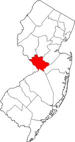
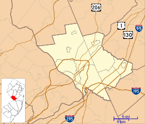 Ackors Corner, New Jersey Location of Ackors Corner in Mercer County Inset: Location of county within the state of New Jersey  Ackors Corner, New Jersey Ackors Corner, New Jersey (New Jersey)  Ackors Corner, New Jersey Ackors Corner, New Jersey (the United States) | |
| Coordinates: 40°20′05″N 74°50′57″W | |
| Country | |
| State | |
| County | Mercer |
| Township | Hopewell |
| Elevation | 256 ft (78 m) |
| GNIS feature ID | 874251[1] |
References
- "Akers Corner". Geographic Names Information System. United States Geological Survey.
- Locality Search, State of New Jersey. Accessed January 9, 2015.
- Mercer County (PDF) (Map). New Jersey Department of Transportation. 2014. Retrieved July 5, 2015.
- Highway Map of Mercer County New Jersey (Map). 1938. Retrieved July 5, 2015.
- Google (July 5, 2015). "Aerial view of Ackors Corner" (Map). Google Maps. Google. Retrieved July 5, 2015.
- Mueller's Automobile Driving and Trolley Map of Mercer County New Jersey Including Morrisville, Penna (Map). A. H. Mueller. 1918. Retrieved July 5, 2015.
This article is issued from Wikipedia. The text is licensed under Creative Commons - Attribution - Sharealike. Additional terms may apply for the media files.