'Amanave, American Samoa
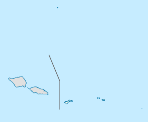
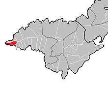
'Amanave (Samoan: 'Āmanave) is a village on the coast of Tutuila Island, American Samoa. It is located close to the island's western tip, Cape Taputapu, and to the south of the village of Poloa. It is located in Lealataua County.
'Amanave | |
|---|---|
Village | |
 'Amanave | |
| Coordinates: 14°19′48″S 170°49′46″W | |
| Country | |
| Territory | |
| Area | |
| • Total | 0.342 sq mi (0.885 km2) |
| Population (2010) | |
| • Total | 250 |
| • Density | 730/sq mi (280/km2) |
'Amanave was severely damaged by the 2009 tsunami. However, of a population of about 500 residents, no deaths were recorded. When the tsunami approached, emergency information was sent by radio and a bell rang in the village. After the tsunami, some residents followed the advice of the Federal Emergency Management Agency (FEMA) and moved into houses on a higher elevation.[1]
Its mayor Aveao Faausu Fonoti received the Community Resiliency Leadership Award at the National Disaster Preparedness Training Center in 2010, due to his handling of the 2009 tsunami. The Executive Director of the center told reporters: "In spite of the fact that something like eighty percent of his village was destroyed, there were no casualties. And based on our research we found that many lives were saved because of his bravery, his leadership, his knowledge."[2]
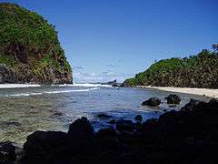
The village is in an area which is renowned for its rugged volcanic coastline.[3] After its confluence with its tributaries near central parts of the village, Laloafu Stream discharges into the Pacific from 'Amanave Bay.[4]:33–6
History
The first formal school established on the island was Atauloma Girls School in 'Amanave, which opened in 1900–1901. Although originally located in the village of 'Amanave, it was later relocated to Afao. Remains from the historic site can still be viewed on the top of the hill in the Atauloma area of Afao village.[5]
During World War II, the single-lane roads which for long had been connecting Alofau in the east to 'Amanave in the west proved inadequate for military requirements. They were therefore replaced by a two-lane, coral-rock-surface road, which could handle the heavy military vehicles.[6][7]
Landmarks
- Cape Taputapu National Natural Landmark is an exhibit of offshore volcanic rocks, shoreline, and blowholes sculpted by waves. Large sculptures of erosion-resistant volcanic rock dot the water shore, and one of these islets is a volcanic vent through which lava poured during the major episode of volcanism that made Tutuila. The total area designated as a U.S. National Natural Landmark is 170 acres. It is the westernmost point on Tutuila Island, located just beyond 'Amanave.[8]
- Amanave Village Marine Protected Area
- Palagi Beach, a beach on Loa inlet, just past 'Amanave and east of Cape Taputapu.
Demographics
| Population growth[9] | |
|---|---|
| 2010 | 250 |
| 2000 | 287 |
| 1990 | 378 |
| 1980 | 269 |
| 1970 | 292 |
| 1960 | 269 |
| 1950 | 209 |
| 1940 | 123 |
| 1930 | 106 |
The 1990 U.S. Census reported 53 houses in 'Amanave. The proportion of 'Amanave inhabitants born outside of American Samoa was 17% in the early 1980s and 29% in the late 1980s. In 1990, 43 percent of village residents were born outside of American Samoa.[4]:33–9
Economy
As of 1995, business license records from the government show eleven commercial enterprises based in the village. Businesses included five grocery stores, a retail shop, a gas station, and several bus companies. There is also banana production on the western side of the village, upslope from the shoreline road near Malama Point. Coconut production occurred east of 'Amanave on the south side of Leafu Stream.[4]:33–10
References
- Esteban, Miguel and Hiroshi Takagi (2015). Handbook of Coastal Disaster Mitigation for Engineers and Planners. Butterworth-Heinemann. Page 81. ISBN 9780128012703.
- http://www.radionz.co.nz/international/pacific-news/188605/american-samoa-village-mayor-to-receive-leadership-award
- Fidgeon, Tamsin (2004). Columbus World Travel Guide 2004-2005. Highbury Columbus Travel Pub. Page 9. ISBN 9781902221847.
- http://www.botany.hawaii.edu/basch/uhnpscesu/pdfs/sam/Pedersen2000vol2AS.pdf
- http://americansamoasea.cyberschool.com/District/1112-Untitled.html
- Shaffer, Robert J. (2000). American Samoa: 100 Years Under the United States Flag. Island Heritage. Page 175. ISBN 9780896103399.
- Gray, John Alexander Clinton (1980). Amerika Samoa. Arno Press. Page 242. ISBN 9780405130380.
- Goldin, Meryl Rose (2002). Field Guide to the Samoan Archipelago: Fish, Wildlife, and Protected Areas. Bess Press. Page 282. ISBN 9781573061117.
- "American Samoa Statistical Yearbook 2016" (PDF). American Samoa Department of Commerce. Archived from the original (PDF) on 2019-02-14. Retrieved 2019-07-25.
| Topics | |||||
|---|---|---|---|---|---|
| Geography | |||||
| Politics |
| ||||
| Economy |
| ||||
| Culture |
| ||||
| Districts |
| ||||
| Islands | |||||
| Villages |
| ||||