Záhorce
Záhorce is a village and municipality in the Veľký Krtíš District of the Banská Bystrica Region of southern Slovakia.
Záhorce | |
|---|---|
Municipality | |
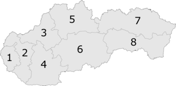
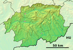 Záhorce Location of Záhorce in the Banská Bystrica Region  Záhorce Location of Záhorce in Slovakia | |
| Coordinates: 48°07′N 19°21′E | |
| Country | |
| Region | Banská Bystrica |
| District | Veľký Krtíš |
| First mentioned | 1236 |
| Area | |
| • Total | 17.98 km2 (6.94 sq mi) |
| Elevation | 156 m (512 ft) |
| Time zone | UTC+1 (CET) |
| • Summer (DST) | UTC+2 (CEST) |
| Postal code | 991 06 (pošta Želovce) |
| Area code(s) | +421-47 |
| Car plate | VK |
| Website | www.zahorce.sk |
Záhorce lies on the right bank of the river Ipeľ in the Krtíš valley . At present, the municipality of Záhorce includes in its territorial division also two former independent villages of Selešťany and Podlužany.
Monuments
The Evangelical church, a simple one-aisle tolerance building with a semi-circularly finished presbytery and a tower of 1781. After a fire in 1831, the church was restored, similarly in 1846. The interior is flat-ceilinged with a fabion. The altar is a simple Baroque column architecture from the 18th century. The church facades are smooth, the windows have a semi-circular finish. The tower, divided by pilasters, is finished with a bell helmet.
External links