Horné Strháre
Horné Strháre (Hungarian: Felsöesztergály) is a village and municipality in the Veľký Krtíš District of the Banská Bystrica Region of southern Slovakia.
Horné Strháre | |
|---|---|
Municipality | |
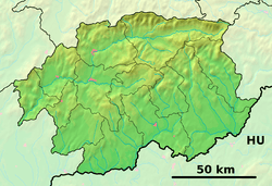
 Horné Strháre Location of Horné Strháre in the Banská Bystrica Region  Horné Strháre Location of Horné Strháre in Slovakia | |
| Coordinates: 48°16′N 19°22′E | |
| Country | |
| Region | Banská Bystrica |
| District | Veľký Krtíš |
| First mentioned | 1243 |
| Area | |
| • Total | 12.78 km2 (4.93 sq mi) |
| Elevation | 244 m (801 ft) |
| Time zone | UTC+1 (CET) |
| • Summer (DST) | UTC+2 (CEST) |
| Postal code | 991 03 (pošta Pôtor) |
| Area code(s) | +421-47 |
| Car plate | VK |
| Website | www.hornestrhare.sk |
History
In historical records the village was first mentioned in 1243 (Eztergur, Vzturgar), when it belonged to Hont Castle. After, it passed to Lords Kacsics and, in 1327, to Szécsényi. From 1554 to 1594 it was occupied by Turks. In the 17th century it belonged to Divín (Zichy) and Modrý Kameň (Balassa)
Genealogical resources
The records for genealogical research are available at the state archive "Statny Archiv in Banska Bystrica, Slovakia"
- Roman Catholic church records (births/marriages/deaths): 1754-1896 (parish B)
- Lutheran church records (births/marriages/deaths): 1786-1836 (parish B)
gollark: No, but I can probably grab one.
gollark: The pumpkin?
gollark: *is interested in API-coded whatever*
gollark: I only have 7 reds left. This is disastrous.
gollark: I bet there'll be at least one halloweenling APed over the week.
External links
- Official website

- https://web.archive.org/web/20070513023228/http://www.statistics.sk/mosmis/eng/run.html
- http://www.e-obce.sk/obec/hornestrhare/horne-strhare.html
- Surnames of living people in Horne Strhare
This article is issued from Wikipedia. The text is licensed under Creative Commons - Attribution - Sharealike. Additional terms may apply for the media files.