West Salem, Wisconsin
West Salem is a village in La Crosse County, Wisconsin, United States, along the La Crosse River. It is part of the La Crosse-Onalaska, WI-MN Metropolitan Statistical Area. The population was 4,799 as of the 2010 Census.
West Salem, Wisconsin | |
|---|---|
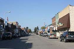 Downtown | |
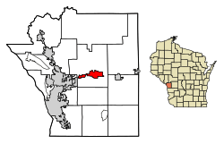 Location of West Salem in La Crosse County, Wisconsin. | |
| Coordinates: 43°53′59″N 91°5′12″W | |
| Country | |
| State | |
| County | La Crosse |
| Government | |
| • Village President | Dennis Manthei |
| • Village Administrator | Teresa Schnitzler |
| Area | |
| • Total | 3.40 sq mi (8.82 km2) |
| • Land | 3.35 sq mi (8.67 km2) |
| • Water | 0.06 sq mi (0.15 km2) |
| Elevation | 741 ft (226 m) |
| Population | |
| • Total | 4,799 |
| • Estimate (2019)[4] | 5,015 |
| • Density | 1,498.80/sq mi (578.68/km2) |
| Time zone | UTC-6 (Central (CST)) |
| • Summer (DST) | UTC-5 (CDT) |
| Area code(s) | 608 |
| FIPS code | 55-86275[5] |
| GNIS feature ID | 1576552[2] |
| Website | www |
History
West Salem was platted in 1856. It was named Salem by a Baptist minister named Elder Card because the word meant "peace" in Arabic and Hebrew. The word West was added to the name when mail was confused with another town in the state named Salem.[6][7]
The donation of approximately ten acres of land to a railway company led to the creation of West Salem. A station was built in West Salem on the original Milwaukee and La Crosse Railway which ran to La Crosse. It was later taken over by the Chicago, Milwaukee and St. Paul Railway (later becoming the Chicago, Milwaukee, St. Paul and Pacific Railroad). The railway used the land to build a depot and tracks.[8]
Geography
West Salem is located at 43°53′59″N 91°5′12″W (43.899795, -91.086614).[9]
According to the United States Census Bureau, the village has a total area of 3.44 square miles (8.91 km2), of which, 3.42 square miles (8.86 km2) of it is land and 0.02 square miles (0.05 km2) is water.[10]
Demographics
| Historical population | |||
|---|---|---|---|
| Census | Pop. | %± | |
| 1880 | 432 | — | |
| 1890 | 542 | 25.5% | |
| 1900 | 725 | 33.8% | |
| 1910 | 840 | 15.9% | |
| 1920 | 1,027 | 22.3% | |
| 1930 | 1,011 | −1.6% | |
| 1940 | 1,254 | 24.0% | |
| 1950 | 1,376 | 9.7% | |
| 1960 | 1,707 | 24.1% | |
| 1970 | 2,180 | 27.7% | |
| 1980 | 3,276 | 50.3% | |
| 1990 | 3,611 | 10.2% | |
| 2000 | 4,540 | 25.7% | |
| 2010 | 4,799 | 5.7% | |
| Est. 2019 | 5,015 | [4] | 4.5% |
| U.S. Decennial Census[11] | |||
2010 census
As of the census[3] of 2010, there were 4,799 people, 1,831 households, and 1,259 families living in the village. The population density was 1,403.2 inhabitants per square mile (541.8/km2). There were 1,869 housing units at an average density of 546.5 per square mile (211.0/km2). The racial makeup of the village was 96.7% White, 0.4% African American, 0.6% Native American, 0.7% Asian, 0.3% from other races, and 1.3% from two or more races. Hispanic or Latino of any race were 1.2% of the population.
There were 1,831 households of which 37.2% had children under the age of 18 living with them, 53.2% were married couples living together, 10.9% had a female householder with no husband present, 4.6% had a male householder with no wife present, and 31.2% were non-families. 26.9% of all households were made up of individuals and 11.9% had someone living alone who was 65 years of age or older. The average household size was 2.48 and the average family size was 2.99.
The median age in the village was 39.2 years. 26% of residents were under the age of 18; 6.3% were between the ages of 18 and 24; 25.5% were from 25 to 44; 26.3% were from 45 to 64; and 15.9% were 65 years of age or older. The gender makeup of the village was 47.4% male and 52.6% female.
2000 census
As of the census[5] of 2000, there were 4,541 people, 1,706 households, and 1,230 families living in the village. The population density was 1,911.2 people per square mile (736.5/km²). There were 1,765 housing units at an average density of 743.0 per square mile (286.3/km²). The racial makeup of the village was 98.04% White, 0.51% African American, 0.42% Native American, 0.44% Asian, 0.07% from other races, and 0.53% from two or more races. Hispanic or Latino of any race were 0.59% of the population.
There were 1,706 households out of which 41.4% had children under the age of 18 living with them, 59.0% were married couples living together, 9.3% had a female householder with no husband present, and 27.9% were non-families. 23.6% of all households were made up of individuals and 10.3% had someone living alone who was 65 years of age or older. The average household size was 2.61 and the average family size was 3.09.
In the village, the population was spread out with 30.0% under the age of 18, 6.3% from 18 to 24, 31.9% from 25 to 44, 18.9% from 45 to 64, and 12.8% who were 65 years of age or older. The median age was 34 years. For every 100 females, there were 95.6 males. For every 100 females age 18 and over, there were 86.6 males.
The median income for a household in the village was $43,449, and the median income for a family was $50,176. Males had a median income of $34,459 versus $22,439 for females. The per capita income for the village was $19,904. About 3.3% of families and 3.5% of the population were below the poverty line, including 4.0% of those under age 18 and 3.4% of those age 65 or over.
Government
The village president is Dennis Manthei. The village administrator is Teresa Schnitzler. The village treasurer is Benjamin Heller.
Education
The public West Salem School District consists of:
- West Salem Elementary School
- West Salem Middle School
- West Salem High School
The private schools are:
- Coulee Region Christian School
- Christ Saint John's Lutheran School
Historic sites
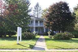
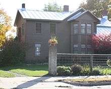
- The Hamlin Garland House
- The Palmer Brother's Octagons
Parks and recreation
- Veterans Memorial Park
- Lake Neshonoc
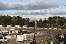
- La Crosse Fairgrounds Speedway
Notable people
- Charles S. Benton, U.S. Representative from New York
- Tom Black, NBA player, graduated from high school in West Salem.
- George G. Bingham, Oregon jurist
- Frank P. Coburn, United States House of Representatives
- Hamlin Garland, writer - West Salem was his summer house, but he was born here.
- Harry W. Griswold, United States House of Representatives
- Michael Huebsch, former Wisconsin State Assembly representative and former director of the Wisconsin Department of Administration
- Jay L. Johnson, United States admiral
- Damian Miller, major league baseball player
- William F. Miller, Wisconsin legislator
- Norbert Nuttelman, Wisconsin legislator and farmer
- Arthur H. Parmelee, football coach and physician
Images
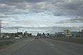 Looking east at West Salem on WIS 16
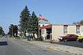 Post office
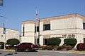 Community Center
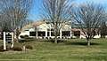 Hazel Brown Leicht Memorial Library
References
- "2019 U.S. Gazetteer Files". United States Census Bureau. Retrieved August 7, 2020.
- "US Board on Geographic Names". United States Geological Survey. 2007-10-25. Retrieved 2008-01-31.
- "U.S. Census website". United States Census Bureau. Retrieved 2012-11-18.
- "Population and Housing Unit Estimates". United States Census Bureau. May 24, 2020. Retrieved May 27, 2020.
- "U.S. Census website". United States Census Bureau. Retrieved 2008-01-31.
- Gard, Robert and L.G. Sorden. The Romance of Wisconsin Placenames. Minocqua, WI: Heartland Press, 1988. ISBN 0-942802-88-8.
- Chicago and North Western Railway Company (1908). A History of the Origin of the Place Names Connected with the Chicago & North Western and Chicago, St. Paul, Minneapolis & Omaha Railways. p. 138.
- "Railroad Influenced Site of West Salem; Neshonoc Was Village". La Crosse Tribune and Leader-Press. April 6, 1930. Retrieved on 2009-08-04 from the Wisconsin Local History & Biography Articles at the website of the Wisconsin Historical Society .
- "US Gazetteer files: 2010, 2000, and 1990". United States Census Bureau. 2011-02-12. Retrieved 2011-04-23.
- "US Gazetteer files 2010". United States Census Bureau. Retrieved 2012-11-18.
- "Census of Population and Housing". Census.gov. Retrieved June 4, 2015.
External links
| Wikimedia Commons has media related to West Salem, Wisconsin. |
- Village of West Salem website
- West Salem School District website
- Sanborn fire insurance maps: 1894 1898 1904 1910 1922
Municipalities and communities of La Crosse County, Wisconsin, United States | ||
|---|---|---|
| Cities | 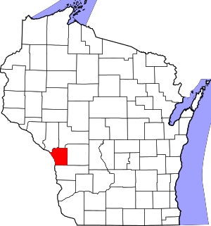 | |
| Villages | ||
| Towns | ||
| CDPs | ||
| Unincorporated communities | ||
| Indian reservation | ||
| Footnotes | ‡This populated place also has portions in an adjacent county or counties | |