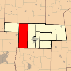
Wilson Township, Audrain County, Missouri
Wilson Township is one of eight townships in Audrain County, Missouri, United States. As of the 2010 census, its population was 1,633.[3]
Wilson Township | |
|---|---|
 | |
| Coordinates: 39°11′22″N 092°01′57″W | |
| Country | United States |
| State | Missouri |
| County | Audrain |
| Area | |
| • Total | 136.71 sq mi (354.09 km2) |
| • Land | 135.93 sq mi (352.07 km2) |
| • Water | 0.78 sq mi (2.03 km2) 0.57% |
| Elevation | 820 ft (250 m) |
| Population (2010) | |
| • Total | 1,633 |
| • Density | 12/sq mi (4.6/km2) |
| FIPS code | 29-80152[2] |
| GNIS feature ID | 0766248 |
History
Wilson Township was established in 1837.[4] The township has the name of Daniel Wilson, a pioneer settler.[5]
Geography
Wilson Township covers an area of 136.7 square miles (354.1 km2) and contains no incorporated settlements. It contains one cemetery, Skull Lick.
The streams of Big Branch, Goodwater Creek, Hitt Branch, Mayes Branch and Possum Walk Creek run through this township.
gollark: https://github.com/SquidDev-CC/CC-Tweaked/blob/master/src/main/resources/assets/computercraft/lua/bios.lua#L104
gollark: It would return exactly the same thing as `os.pullEventRaw`, actually.
gollark: If you do this, I *will* orbital-laser you, if I can make the orbital lasers work.
gollark: `term.scroll` exists.
gollark: `coroutine.yield` is native.
References
- "US Board on Geographic Names". United States Geological Survey. 2007-10-25. Retrieved 2008-01-31.
- "U.S. Census website". United States Census Bureau. Retrieved 2008-01-31.
- "Geographic Identifiers: 2010 Demographic Profile Data (G001): Wilson township, Audrain County, Missouri". U.S. Census Bureau, American Factfinder. Archived from the original on February 12, 2020. Retrieved June 25, 2013.
- "Audrain County Place Names, 1928-1945 (archived)". The State Historical Society of Missouri. Archived from the original on 24 June 2016. Retrieved 30 August 2016.
- Eaton, David Wolfe (1916). How Missouri Counties, Towns and Streams Were Named. The State Historical Society of Missouri. pp. 204.
External links
Municipalities and communities of Audrain County, Missouri, United States | ||
|---|---|---|
| Cities | 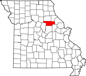 Map of Missouri highlighting Audrain County | |
| Villages | ||
| Townships | ||
| Unincorporated communities | ||
| Ghost town | ||
| Footnotes | ‡This populated place also has portions in an adjacent county or counties | |
This article is issued from Wikipedia. The text is licensed under Creative Commons - Attribution - Sharealike. Additional terms may apply for the media files.