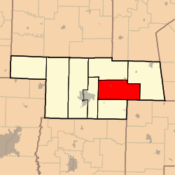
Linn Township, Audrain County, Missouri
Linn Township is one of eight townships in Audrain County, Missouri, United States. As of the 2010 census, its population was 615.[3]
Linn Township | |
|---|---|
 | |
| Coordinates: 39°12′26″N 091°43′28″W | |
| Country | United States |
| State | Missouri |
| County | Audrain |
| Area | |
| • Total | 75.71 sq mi (196.08 km2) |
| • Land | 75.27 sq mi (194.94 km2) |
| • Water | 0.44 sq mi (1.13 km2) 0.58% |
| Elevation | 787 ft (240 m) |
| Population (2010) | |
| • Total | 615 |
| • Density | 8/sq mi (3.2/km2) |
| FIPS code | 29-43148[2] |
| GNIS feature ID | 0766242 |
The origin of the name Linn Township is disputed.[4]
Geography
Linn Township covers an area of 75.7 square miles (196.1 km2) and contains one incorporated settlement, Rush Hill. It contains one cemetery, New Providence.
The streams of Bean Branch, Johns Branch and Mams Slough run through this township.
gollark: https://hackaday.com/2022/06/23/around-gps-in-100-videos/
gollark: You should only do courses on important specific topics, such as all of GPS.
gollark: Maybe in *electromagnetism*.
gollark: Cesium ones and the maser things are quite niche.
gollark: I put "rubidium" in as a search term.
References
- "US Board on Geographic Names". United States Geological Survey. 2007-10-25. Retrieved 2008-01-31.
- "U.S. Census website". United States Census Bureau. Retrieved 2008-01-31.
- "Geographic Identifiers: 2010 Demographic Profile Data (G001): Linn township, Audrain County, Missouri". U.S. Census Bureau, American Factfinder. Archived from the original on February 12, 2020. Retrieved June 25, 2013.
- "Audrain County Place Names, 1928-1945 (archived)". The State Historical Society of Missouri. Archived from the original on 24 June 2016. Retrieved 30 August 2016.CS1 maint: BOT: original-url status unknown (link)
External links
Municipalities and communities of Audrain County, Missouri, United States | ||
|---|---|---|
| Cities | 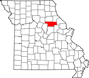 Map of Missouri highlighting Audrain County | |
| Villages | ||
| Townships | ||
| Unincorporated communities | ||
| Ghost town | ||
| Footnotes | ‡This populated place also has portions in an adjacent county or counties | |
This article is issued from Wikipedia. The text is licensed under Creative Commons - Attribution - Sharealike. Additional terms may apply for the media files.