Whakapapa River
The Whakapapa River in New Zealand trickles off the Whakapapa skifield of Mount Ruapehu, down the western slopes of the mountain, passing near Ōwhango before finally merging with the Whanganui River just east of Kakahi at 38°55.92′S 175°24.5′E.
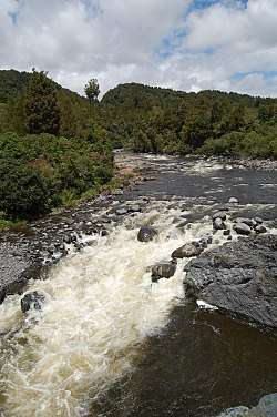
Whakapapa River near Owhango
Peter McIntyre had a home near Kakahi overlooking the confluence of the Whanganui and Whakapapa rivers, and painted several oil landscapes of the Whakapapa River. After his death, the Whakapapa River undermined the white pumice cliffs where his house was built and claimed the house as its own.
Occasionally people kayak a 7.5-kilometre (4.7 mi) stretch of the river from near Ōwhango (38°59.80′S 175°23.92′E) to near Kakahi (38°56.41′S 175°24.50′E).
Tributaries
| Tributary Name | Length (km) | km From Mouth | Confluence Coordinates |
|---|---|---|---|
| Mount Ruapehu | River Source | 39°15.67′S 175°33.84′E | |
| Tepure Stream | 39°03.54′S 175°23.78′E | ||
| Whanganui River | River Mouth | 0 km | 38°55.92′S 175°24.50′E |
gollark: You already did in 2022.
gollark: It varies depending on some apionic field coupling constants.
gollark: Not really.
gollark: We proved it using A-formic ZFCN set theory recently, setting it on much sturdier theoretical ground.
gollark: Apiorics calculus is valid for low-energy bees, which is the common case.
This article is issued from Wikipedia. The text is licensed under Creative Commons - Attribution - Sharealike. Additional terms may apply for the media files.