West Muna Regency
West Muna Regency (Indonesian: Kabupaten Muna Barat) is a new regency of Southeast Sulawesi, Indonesia, established in 2014 under Act No.14 of 2014, dated 23 July 2014 by separation from the Muna Regency. It covers an area of 1,022.9 km2, and the districts comprising it had a population of 71,632 at the 2010 Census;[2] the latest official estimate (as at 2018) is 78,630.[3] The administrative centre lies at Laworo. [4]
West Muna Regency Kabupaten Muna Barat | |
|---|---|
 Seal | |
| Motto(s): Wite Barakati | |
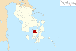
 Location within Southeast Sulawesi | |
| Coordinates: 4.7900362°S 122.4966354°E | |
| Country | Indonesia |
| Region | Sulawesi |
| Province | Southeast Sulawesi |
| Established | 24 July 2014[1] |
| Founded by | Government of Indonesia |
| Capital | Laworo |
| Government | |
| • Regent | Laode Muhammad Rajiun Tumada |
| • Vice Regent | Ahmad Lamani |
| Area | |
| • Total | 1,022.9 km2 (394.9 sq mi) |
| Population (2018) | |
| • Total | 78,630 |
| • Density | 77/km2 (200/sq mi) |
| Time zone | UTC+8 (ICST) |
| Area code | (+62) 403 |
| Website | munabaratkab |
Administrative districts
The West Muna Regency, created in 2014, is divided into the following eleven districts (kecamatan),[5] tabulated below with their 2010 Census populations.[6]
| Name | Area in km2. | Population Census 2010 | No. of Villages | Post Code |
|---|---|---|---|---|
| Tiworo Kepulauan1 (Tiworo Islands) | 64.2 | 6,406 | 9 | 93653 |
| Maginti2 | 51.1 | 8,226 | 8 | 93643 |
| Tiworo Tengah3 (Central Tiworo) | 66.2 | 6,503 | 8 | 93654 |
| Tiworo Selatan (South Tiworo) | 48.5 | 4,830 | 5 | 93644 |
| Tiworo Utara (North Tiworo) | 46.7 | 4,863 | 7 | 93656 |
| Lawa | 134.3 | 7,430 | 8 | 93651 |
| Sawerigadi | 104.2 | 6,284 | 10 | 93657 |
| Barangka | 43.5 | 5,978 | 8 | 93650 |
| Wadaga | 106.6 | 5,706 | 7 | 93652 |
| Kusambi | 71.8 | 10,699 | 10 | 93655 |
| Napano Kusambi | 86.5 | 4,707 | 6 | 93658 |
Notes:
- 1 Tiworo Kepulauan district comprises a group of 12 islands off the northwest coast of Muna.
- 2 Maginto district includes 7 small islands off the west coast of Muna.
- 3 Tiworo Tengah district includes 12 small islands off the west coast of Muna.
gollark: +>markov 258639553357676545 3
gollark: +>markov 258639553357676545 3
gollark: +>markov 258639553357676545 3
gollark: +>markov 258639553357676545 3
gollark: +>markov 258639553357676545 3
References
- "Pembentukan Kabupaten Muna Barat Di Provinsi Sulawesi Tenggara" (PDF) (in Indonesian). Government of Indonesia.
- Biro Pusat Statistik, Jakarta, 2011.
- Badan Pusat Statistik, Jakarta, 2019.
- "UNDANG-UNDANG REPUBLIK INDONESIA NOMOR 14 TAHUN 2014 PEMBENTUKAN KABUPATEN MUNA BARAT DI PROVINSI SULAWESI TENGGARA" (in Indonesian). Government of Indonesia.
- "Pembagian Administrasi Kabupaten Muna Barat" (in Indonesian). Peta Tematik Indonesia.
- Biro Pusat Statistik, Jakarta, 2011.
This article is issued from Wikipedia. The text is licensed under Creative Commons - Attribution - Sharealike. Additional terms may apply for the media files.

