South Konawe Regency
South Konawe Regency (Kabupaten Konawe Selatan) is a regency of Southeast Sulawesi Province, Indonesia. It covers an area of 4,514.21 km2 and had a population of 264,587 at the 2010 Census[2] and of 294,815 at the 2015 Census.[3] The administrative centre is in the town of Andoolo.
South Konawe Regency Kabupaten Konawe Selatan | |
|---|---|
 Seal | |
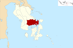
 Location within Southeast Sulawesi | |
| Coordinates: 3.4114°S 122.0200°E | |
| Country | Indonesia |
| Province | Southeast Sulawesi |
| Capital | Andoolo |
| Government | |
| • Regent | Surunuddin Dangga |
| • Vice Regent | Arsalim |
| Area | |
| • Total | 4,514.21 km2 (1,742.95 sq mi) |
| Population (2015)[1] | |
| • Total | 294,815 |
| • Density | 65/km2 (170/sq mi) |
| Time zone | UTC+8 (ICST) |
| Area code | (+62) 401 |
| Website | konaweselatankab |
Administration
The South Konawe Regency was divided at 2010 into twenty-two districts (kecamatan), tabulated below with their areas and their 2010 Census population,[4] together with the latest (2013) official estimates of population.[5]
| Name | Area in km2 | Population Census 2010 | Population Estimate 2013 |
|---|---|---|---|
| Tinanggea | 21,320 | 22,676 | |
| Lalembuu | 204.80 | 15,603 | 16,481 |
| Andoolo | 103.61 | 16,316 | 17,303 |
| Buke | 185.61 | 13,236 | 14,037 |
| Palangga | 177.83 | 12,287 | 13,030 |
| Palangga Selatan (South Palangga) | 110.21 | 6,139 | 6,510 |
| Baito | 152.71 | 7,562 | 8,020 |
| Lainea | 210.11 | 8,870 | 9,407 |
| Laeya | 277.97 | 19,005 | 20,155 |
| Kolono | 344.59 | 13,602 | 14,425 |
| Laonti | 406.53 | 9,444 | 9,915 |
| Moramo | 237.89 | 12,976 | 13,761 |
| Moramo Utara (North Moramo) | 189.05 | 7,174 | 7,608 |
| Konda | 132.84 | 18,131 | 19,112 |
| Wolasi | 160.28 | 4,730 | 5,016 |
| Ranomeeto | 96.57 | 16,223 | 17,325 |
| Ranomeeto Barat (West Ranomeeto) | 76.07 | 6,517 | 7,007 |
| Landono | 125.00 | 11,470 | 12,164 |
| Mowila | 127.41 | 11,188 | 11,865 |
| Angata | 329.54 | 14,905 | 15,807 |
| Benua | 138.31 | 9,734 | 10,323 |
| Basala | 8,155 | 8,648 |
Since 2010, three additional districts have been created in 2014 by the division of existing districts - Andoolo Barat (West Andoolo), Kolono Timur (East Kolono) and Sabulakoa (formerly part of Landono district).
gollark: There is always a bigger idiot.
gollark: Apparently 5G NR has the tower know your position to within a few metres for beamforming.
gollark: Mobile network specs require towers to have very, very accurate timers, and they can do multilateration (and without that know your location down to the nearest cell, at least).
gollark: I guess lots of the phone network gets timing from GPS, but still.
gollark: It's not satellites, it's terrestrial infrastructure and computing.
References
- Badan Pusat Statistik, Jakarta, 2018.
- Biro Pusat Statistik, Jakarta, 2011.
- Badan Pusat Statistik, Jakarta, 2018.
- Biro Pusat Statistik, Jakarta, 2011.
- Badan Pusat Statistik, Jakarta, 2018.
This article is issued from Wikipedia. The text is licensed under Creative Commons - Attribution - Sharealike. Additional terms may apply for the media files.

