Konawe Regency
Konawe Regency is one of the regencies in the province of Southeast Sulawesi, Indonesia. The capital of the regency is Unaaha. The regency was once known as the district of Kendari. The regency had a population of 241,428 at the 2010 Census, but has since been reduced by the separation of the offshore island districts (comprising Wawonii Island) as the new Konawe Islands Regency in 2013. It now covers 4,435.3 km2 and had an official estimate of population for 2018 of 253,659.[2] Prior to its division in 2003, 2007 and 2013, Konawe was known as the rice granary of the province of Southeast Sulawesi because half of the province's rice production comes from Konawe.
Konawe Regency | |
|---|---|
 Seal | |
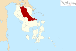
 Location within Southeast Sulawesi | |
| Coordinates: 3°51′12″S 122°03′13″E | |
| Country | Indonesia |
| Province | Southeast Sulawesi |
| Capital | Unaaha |
| Government | |
| • Regent | Kery Saiful Konggoasa |
| • Vice Regent | Parinringi |
| Area | |
| • Total | 4,435.3 km2 (1,712.5 sq mi) |
| Population (2018)[1] | |
| • Total | 253,659 |
| • Density | 57/km2 (150/sq mi) |
| Time zone | UTC+8 (ICST) |
| Area code | (+62) 408 |
| Website | konawekab.go.id |
History
Konawe Regency was established pursuant to Law No 29 of 1959 (dated 4 July 1959) on the formation of second-level regions in Southeast Sulawesi with the name of Kendari Regency, with the capital being the city of Kendari.
When the Municipality of Kendari was first established under Law No 6 of 1995 (which separated Kendari City from Kendari Regency), the residual Kendari Regency consisted of 19 districts (kecamatan) with 334 villages. Over time, administrative changes led to the changes in the numbers of districts and villages. In 2002 Kendari Regency consisted of 23 districts with 631 villages. Based on Government Regulation No. 26 of 2004, on 28 September 2004, the residual regency changed its name to Konawe Regency.
In 2003, the south part of the regency was formed into a separate South Konawe Regency (Konawe Selatan) covering 11 districts, and subsequently in 2007 the northern districts were likewise split off to form a new North Konawe Regency (Konawe Utara). Finally, in 2013, the 7 districts comprising Wawonii Island were split off to form a new Konawe Islands Regency (Konawe Kapulauan).
Administration
Konawe Regency, since the removal of the 7 districts on Wawonii Island to form a new Konawe Islands Regency and the creation of 4 new districts within the remaining area, is now divided into 27 districts (kecamatan), tabulated below with their 2010 Census population.
| Name | Area in km2 | Population Census 2010[3] | Population Estimate 2015[4] | No. of Villages | Post Code |
|---|---|---|---|---|---|
| Soropia 1 | 61.73 | 7,753 | 8,502 | 15 | 93451 |
| Lalonggasumeeto | 40.78 | 4,612 | 5,057 | 12 | 93450 |
| Sampara | 60.01 | 11,719 | 8,405 | 15 | 93458 |
| Anggalomoare | 2 | 2 | 4,435 | 10 | 93455 |
| Bondoala | 133.35 | 8,199 | 4,414 | 9 | 93457 |
| Morosi | 3 | 3 | 4,577 | 10 | 93456 |
| Besulutu | 111.26 | 6,759 | 7,412 | 16 | 93459 |
| Kapoiala | 45.42 | 4,063 | 4,455 | 14 | 93454 |
| Lambuya | 78.39 | 6,605 | 7,243 | 11 | 93464 |
| Uepai | 118.76 | 11,819 | 12,960 | 19 | 93466 |
| Puriala | 268.78 | 7,405 | 8,120 | 16 | 93411 -93464 |
| Onembute | 99.13 | 5,941 | 6,515 | 12 | 93465 |
| Pondidaha | 156.28 | 10,437 | 11,445 | 18 | 93467 |
| Wonggeduku | 113.76 | 19,817 | 13,005 | 16 | 93468 |
| Wonggeduku Barat (West Wonggeduku) | 4 | 4 | 8,725 | 14 | 93469 |
| Amonggedo | 123.75 | 9,282 | 10,178 | 15 | 93463 |
| Wawotobi | 67.68 | 20,177 | 22,125 | 19 | 93462 |
| Meluhu | 207.03 | 4,988 | 5,470 | 9 | 93472 |
| Konawe | 17.82 | 8,035 | 8,811 | 12 | 93462 |
| Unaaha | 33.75 | 22,694 | 24,886 | 12 | 93411 -93418 |
| Anggaberi | 75.01 | 6,150 | 6,743 | 8 | 93417 -93419 |
| Abuki | 338.84 | 14,407 | 7,369 | 12 | 93452 |
| Padangguni | 5 | 5 | 8,429 | 11 | 93442 |
| Latoma | 936.34 | 2,363 | 2,591 | 13 | 93471 |
| Tongauna | 223.77 | 15,451 | 16,943 | 20 | 93460 |
| Asinua | 298.72 | 2,480 | 2,720 | 8 | 93441 |
| Routa | 2,188.58 | 1,892 | 2,075 | 8 | 93453 |
Note:
- 1 includes 4 offshore islands.
- 2 included in figures for Sampara district, from which it was cut out
- 3 included in figures for Bondoala district, from which it was cut out.
- 4 included in figures for Wonggeduku district, from which it was cut out.
- 5 included in figures for Abuki district, from which it was cut out.
References
- Badan Pusat Statistik, Jakarta, 2019.
- Badan Pusat tatistik, Jakarta, 2019.
- Biro Pusat Statistik, Jakarta, 2011
- Badan Pusat Statistik, Jakarta, 2018

