Watershoot Bay
Watershoot Bay is a bay on the southernmost tip of the Isle of Wight, England. It lies 1 1⁄2 miles (2.4 km) to the south-west of the village of Niton.[1] It faces south out into the English Channel, and is one of the smallest and remotest bays of the Isle of Wight with a rocky shoreline only around 500 feet (150 m) in length. It lies to the west of St. Catherine's Point lighthouse and is surrounded by a 170-acre area of undulating grassland and scrub owned by the National Trust and known as Knowles Farm.[2]
| Watershoot Bay | |
|---|---|
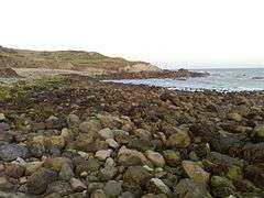 Watershoot Bay looking to the East | |
 Watershoot Bay Location within the Isle of Wight | |
| Civil parish |
|
| Ceremonial county | |
| Region | |
| Country | England |
| Sovereign state | United Kingdom |
The beach is composed predominantly of sandstone, chalk and chert boulders (which are around 90 to 110 million years old) which are rich in fossils.[3]
The bay is best accessed from the car park about 350 yards (320 m) to the north or from the road that leads to the lighthouse but will involve a hike over rough terrain.[1]
The name of the bay may have come from that of a sloop lost there in 1755.[4] The bay was home to a boathouse from the mid 19th century to early 20th century.[5]
References
- Google (14 December 2018). "Watershoot Bay" (Map). Google Maps. Google. Retrieved 14 December 2018.
- St Catherine's Down and Knowles Farm
- "Dinosaur Isle Teachers' Guide" (PDF). Isle of Wight Council. 2005.
- Peter Bruce (May 2008). Wight Hazards. Boldre Marine. p. 37. ISBN 978-1-871680-51-5.
- "Site of boat house, Watershoot Bay, Isle of Wight". National Trust.