Niton
Niton is a village on the Isle of Wight, west of Ventnor, with a population of 1142. It has one pub, several churches, a pottery workshop/shop, a pharmacy , a busy volunteer run library, a medical centre and three local shops including a post office. The post office includes a café that serves as a local meeting place. The village also offers a primary school with a co-located pre-school and nursery.
| Niton | |
|---|---|
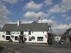 The White Lion, a pub in the village. | |
 Niton Location within the Isle of Wight | |
| Population | 2,082 (2011 census including Little Atherfield and Puckaster)[1] |
| OS grid reference | SZ507765 |
| Civil parish |
|
| Unitary authority | |
| Ceremonial county | |
| Region | |
| Country | England |
| Sovereign state | United Kingdom |
| Post town | VENTNOR |
| Postcode district | PO38 |
| Dialling code | 01983 |
| Police | Hampshire |
| Fire | Isle of Wight |
| Ambulance | Isle of Wight |
| UK Parliament | |
Geography
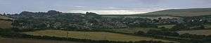
Niton village is split in half by a break in the inner cliff, through which passes the main road. Upper Niton lies in a hollow and is set around a crossroads.
The lower part of the village, below the inner cliff on Reeth Bay, is known as Niton Undercliff, and was a small fishing hamlet up until the 19th Century. This part of Niton then flourished in Victorian times due to the popularity of Ventnor as a health resort, and many mansions and holiday cottages were built there.
Mount Cleves House was originally constructed in the late 1700s, and substantially remodelled in the early 1800s. Its residents included a Mr Kirkpatrick who owned the Isle of Wight Bank at the time and the owner of the Mortimer Foundry in Newport.[2]
The road along the Undercliff continues east towards Ventnor, but a major landslip in February 2014 has closed it to vehicular traffic between Niton and Ventnor, although it remains open for walkers and riders (as at November 2016). The Undercliff at Niton includes the most southerly point of the Isle of Wight, St. Catherine's Point and St. Catherine's Lighthouse. That is also where the Navtex transmitting station is located.
The source of the Eastern Yar is in the parish, just north of the village.[3]
History
Close to Niton is a natural seaport (Puckaster Cove), which is believed to have been used by Greek and Phoenician Bronze Age Britain traders.[5]
Niton lighthouse
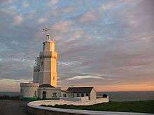
St. Catherine's Lighthouse was bombed in World War II, receiving a direct hit on the boiler house that killed three lighthouse keepers, Principal Keeper R T Grenfell, Assistant Keeper C. Tompkins and Assistant Keeper W.E. Jones.[6] The lighthouse itself was only slightly damaged, its lens only being chipped; the same lens is still used today. St. Catherine’s Lighthouse was automated in 1997 with the keepers leaving the lighthouse on 30 July.[6]
%2C_IW%2C_UK.jpg)
Niton Church
Radio
Marconi used Knowles Farm in Niton for radio experiments, when he was living on the island in the late 1890s and early 1900s. In January 1901, he transmitted radio signals a record 186 miles from there to his Lizard Radio Telegraph Station at the southern tip of Cornwall. The farm has a stone into which is cut the inscription, "This is to commemorate that Marconi set up a wireless experimental station here in A.D. 1900". While in Niton, Marconi stayed at the Royal Sandrock Hotel, which no longer exists.
A ship-to-shore radio station was established in 1900, and Niton Radio (callsign GNI) was maintained as a coastal radio station known to yachtmasters. It was featured in a British Telecom International information film. It finally closed, along with the rest of the coastal radio network, in 1997.[7] The Navtex transmitter at St. Catherine's Lighthouse is still in operation as of 2013 (Navtex is a shore-to-ship service). For the purpose of extended Shipping forecasts, the Met Office uses Niton as the name of the forecast area covering the Atlantic from FitzRoy, North to Irish Sea and East to Thames.[8]
Surfing
Niton has a reputation as a notoriously dangerous spot for Surfboarding. A powerful rip current and a rocky landing await the surfer who attempts to tame Niton's powerful shore break.[9]
Transport
Southern Vectis bus route 6 serves the village on its way between Newport and Ventnor.[10] During the summer, the Island Coaster also runs through the village.[11]
Notable people
Penrhyn Grant Jones, British Consul, China and Assistant Judge of the British Supreme Court for China grew up in Niton. His father Frederick Topham Jones was the proprietor of the Royal Sandrock Hotel.
The band Champs originate from Niton.
Notes and references
- "Civil Parish population 2011". Retrieved 19 October 2015.
- Historic England. "Details from listed building database (1209276)". National Heritage List for England. Retrieved 29 June 2014.
- "River Yar Trail - Source to Sea". WightCam. Archived from the original on 23 April 2009. Retrieved 17 June 2009.
- "English Parishes & Welsh Communities N&C 2004". www.statistics.gov.uk. Retrieved 3 May 2007.
- Adams, William Henry Davenport (1877). Nelsons' hand-book to the Isle of Wight. Oxford University.
Cotentin Peninsula trade Isle of Wight.
- "St. Catherine's Lighthouse". Trinity House. Retrieved 22 October 2017.
- "Coastradio reference site".
- "Extended Outlook". Retrieved 21 July 2016.
- "Niton".
- "Southern Vectis - bus route 6". Southern Vectis. 2008. Archived from the original on 22 March 2008. Retrieved 4 May 2008.
- "Southern Vectis Island Coaster". Southern Vectis. Archived from the original on 23 July 2008. Retrieved 16 June 2009.
| Wikimedia Commons has media related to Niton, Isle of Wight. |
| Unitary authorities | |
|---|---|
| Major settlements | |
| Rivers | |
| Topics | |