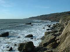
Binnel Bay
Binnel Bay is a bay on the southeast coast of the Isle of Wight, England. It lies between the villages of St. Lawrence and Niton. It faces south towards the English Channel, its shoreline is just under one mile (1.6 km) in length.[1] It stretches from Binnel Point in the east to Puckaster Cove in the west. The bay is hard to access and has a rocky shoreline and is covered with large boulders of Masonry.[2]
| Binnel Bay | |
|---|---|
 Binnel Bay looking southwest, with St. Catherine's Point in the distance | |
 Binnel Bay Location within the Isle of Wight | |
| Civil parish |
|
| Ceremonial county | |
| Region | |
| Country | England |
| Sovereign state | United Kingdom |
The bay is remote and is best viewed from Binnel Point.
History

William Spindler, an eccentric German industrialist, tried to build a harbour and resort on the bay to rival Ventnor in the Victorian era though he died before it could be compleated.[3] In 1882, Spindler bought a large estate including a house which belonged to Sir Richard Worsley, 7th Baronet the island's governor until his death (now the Old Park Hotel). He planned to create a town and planted trees, laid some roads but most noticeably created a seawall in the bay, dubbed Spindler's Folly.[4] The seawall was substantial but had poor foundations as it had foundations been built on blue slipper clay it fell into disrepair due to the force of the sea and gales.[5] The remains of this can be seen scattered around the bay today.
References
- Google (2 September 2018). "Woody Bay" (Map). Google Maps. Google. Retrieved 2 September 2018.
- "Binnel Bay". thebeachguide.co.uk. Retrieved 14 December 2018.
- D Wheeler. "Victorian Ventnor". Whight Life.
- "Pilot the Isle of Wight: Puckaster Cove to Bembridge". Yachting Monthly. June 2012.
- Peter Bruce (May 2008). Wight Hazards. Boldre Marine. pp. 46–. ISBN 978-1-871680-51-5.