Waterborough Parish, New Brunswick
Waterborough is a civil parish[lower-alpha 1] in Queens County, New Brunswick, Canada.[2]
Waterborough | |
|---|---|
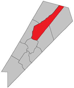 Location within Queens County, New Brunswick. | |
| Coordinates: 45.84°N 64.59°W | |
| Country | |
| Province | |
| County | Queens County |
| Established | 1786 |
| Area | |
| • Land | 445.55 km2 (172.03 sq mi) |
| Population (2016)[1] | |
| • Total | 847 |
| • Density | 1.9/km2 (5/sq mi) |
| • Change 2011-2016 | |
| • Dwellings | 885 |
| Time zone | UTC-4 (AST) |
| • Summer (DST) | UTC-3 (ADT) |
For governance purposes it forms the local service district of the parish of Waterborough.[3]
History
Waterborough Parish was established in 1786. The Parish included Canning Parish until 1827, a portion of Chipman Parish until 1835 and most of Cambridge Parish until 1852.
Delineation
Waterborough Parish is defined in the Territorial Division Act[2] as being bounded:
- Southeast by Johnston and Brunswick Parishes; northeast by the County line; northwest by Chipman Parish and a line along the centre of Grand Lake from the mouth of Coal Creek to Mill Cove, and southwest by Cambridge Parish.
Communities
Parish population total does not include incorporated municipalities (in bold):
|
|
|
Bodies of water and islands
This is a list of rivers, lakes, streams, creeks, marshes and Islands that are at least partially in this parish
Demographics
Access Routes
Highways and numbered routes that run through the parish, including external routes that start or finish at the parish limits:[7]
|
|
|
|
See also
Notes
- Civil parishes served a variety of government functions until 1966, when the new Municipalities Act stripped them of their responsibilities; they continue to provide convenient boundaries for government uses, especially electoral districts and local service districts. Statistics Canada uses civil parishes as census subdivisions for all parts of the province that are not within municipalities and similar entities.
References
- "Census Profile, 2016 Census Waterborough, Parish [Census subdivision], New Brunswick". Statistics Canada. Retrieved September 27, 2019.
- "Chapter T-3 Territorial Division Act". Government of New Brunswick. Retrieved 22 July 2020.
- "New Brunswick Regulation 84-168 under the Municipalities Act (O.C. 84-582)". Government of New Brunswick. Retrieved 19 July 2020.
- Statistics Canada: 2001, 2006 census
- Profile: Waterborough Parish, New Brunswick
- 2011 Statistics Canada Census Profile: Waterborough Parish, New Brunswick
- Atlantic Canada Back Road Atlas ISBN 978-1-55368-618-7
Places adjacent to Waterborough Parish, New Brunswick | ||||||||||
|---|---|---|---|---|---|---|---|---|---|---|
| ||||||||||
| Subdivisions |
|
|---|---|
| Cities | |
| Counties | |
| |