Cambridge Parish, New Brunswick
Cambridge is a civil parish[lower-alpha 1] in Queens County, New Brunswick, Canada.[2]
Cambridge | |
|---|---|
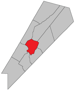 Location within Queens County, New Brunswick. | |
| Coordinates: 45.84°N 64.59°W | |
| Country | |
| Province | |
| County | Queens County |
| Established | 1852 |
| Area | |
| • Land | 113.65 km2 (43.88 sq mi) |
| Population (2016)[1] | |
| • Total | 647 |
| • Density | 5.7/km2 (15/sq mi) |
| • Change 2011-2016 | |
| • Dwellings | 617 |
| Time zone | UTC-4 (AST) |
| • Summer (DST) | UTC-3 (ADT) |
For governance purposes it is divided between the village of Cambridge-Narrows and the local service district of the parish of Cambridge.[3]
History
Cambridge Parish was created from Wickham Parish and Waterborough Parish in 1852, and was named for Prince Adolphus-Frederick, Duke of Cambridge (1774-1850) and uncle of Queen Victoria.
Delineation
Cambridge Parish is defined in the Territorial Division Act[2] as being bounded:
- Beginning on the northeastern shore of the Saint John River, at the southeast angle of lot number sixteen, granted to Isaac Gilbert; thence following the course of the lower or southeastern line of said lot numbered sixteen northeasterly until it meets the waters of the Grand Lake; thence by the waters of the Grand Lake to the road[lower-alpha 2] leading from Mill Cove on the said lake, to Fowlers Cove on the Washademoak Lake; thence southeasterly by said road to Washademoak Lake; thence southwesterly by the waters of the Washademoak Lake and through the Colwells Creek and Lawson Passage to the Saint John River; and thence following the shore of the Saint John River up stream to the place of beginning.
Communities
Parish population total does not include incorporated municipalities (in bold):
|
|
Bodies of water & Islands
This is a list of rivers, lakes, streams, creeks, marshes and Islands that are at least partially in this parish
- Coreys Island
- Nevers Island
Demographics
Access Routes
Highways and numbered routes that run through the parish, including external routes that start or finish at the parish limits:[6]
|
|
|
|
See also
Notes
- Civil parishes served a variety of government functions until 1966, when the new Municipalities Act stripped them of their responsibilities; they continue to provide convenient boundaries for government uses, especially electoral districts and local service districts. Statistics Canada uses civil parishes as census subdivisions for all parts of the province that are not within municipalities and similar entities.
- Fowler Road.
References
- "Census Profile, 2016 Census Cambridge, Parish [Census subdivision], New Brunswick". Statistics Canada. Retrieved September 27, 2019.
- "Chapter T-3 Territorial Division Act". Government of New Brunswick. Retrieved 22 July 2020.
- "New Brunswick Regulation 84-168 under the Municipalities Act (O.C. 84-582)". Government of New Brunswick. Retrieved 19 July 2020.
- Statistics Canada: 2001, 2006 census
- 2011 Statistics Canada Census Profile: Cambridge Parish, New Brunswick
- Atlantic Canada Back Road Atlas ISBN 978-1-55368-618-7
Places adjacent to Cambridge Parish, New Brunswick | |
|---|---|
| Subdivisions |
|
|---|---|
| Cities | |
| Counties | |
| |