Chipman Parish, New Brunswick
Chipman is a civil parish[lower-alpha 1] in Queens County, New Brunswick, Canada.[2]
Chipman | |
|---|---|
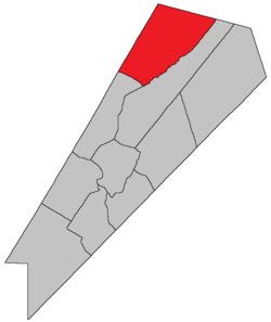 Location within Queens County, New Brunswick. | |
| Country | |
| Province | |
| County | Queens County |
| Established | 1835 |
| Area | |
| • Land | 483.44 km2 (186.66 sq mi) |
| Population (2016)[1] | |
| • Total | 913 |
| • Density | 1.9/km2 (5/sq mi) |
| • Change 2011-2016 | |
| • Dwellings | 541 |
| Time zone | UTC-4 (AST) |
| • Summer (DST) | UTC-3 (ADT) |
For governance purposes it is divided between the village of Chipman and the local service district of the parish of Chipman.[3]
History
Chipman Parish was created in 1835 from Brunswick Parish and Canning Parish, and was named for Ward Chipman Jr. (1787-1851), the chief justice of New Brunswick from 1834-1851. It included the eastern part of Waterborough Parish until 1896.
Delineation
Chipman Parish is defined in the Territorial Division Act[2] as being bounded:
- Northwest and northeast by the County lines; southwest by a line beginning on the Sunbury County line, intersected by the northern line of lot number nine[lower-alpha 2] on the eastern side of the Hardwood Ridge Road;[lower-alpha 3] thence easterly along said line to the northeast angle of said lot; thence south forty-five degrees east to Salmon Bay; thence southeasterly in a direct line to Indian Point; thence easterly up the northeast arm of Grand Lake to Coal Creek; thence easterly up Coal Creek to the southeast angle of lot number one, surveyed for Malcolm Carmichael, at the Round Turns on said Coal Creek; thence northeasterly parallel to the northwest line of Brunswick Parish to the County line.
Communities
Parish population total does not include incorporated municipalities (in bold).
|
|
|
Bodies of water & Islands
This is a list of rivers, lakes, streams, creeks, marshes and Islands that are at least partially in this parish
- Gaspereau River
- Salmon River
Demographics
Access Routes
Highways and numbered routes that run through the parish, including external routes that start or finish at the parish limits:[7]
See also
Notes
- Civil parishes served a variety of government functions until 1966, when the new Municipalities Act stripped them of their responsibilities; they continue to provide convenient boundaries for government uses, especially electoral districts and local service districts. Statistics Canada uses civil parishes as census subdivisions for all parts of the province that are not within municipalities and similar entities.
- Now within lot 157 due to a resurvey and redivision of the area.
- Now part of Route 10.
References
- "Census Profile, 2016 Census: Chipman, Parish [Census subdivision], New Brunswick". Statistics Canada. Retrieved September 27, 2019.
- "Chapter T-3 Territorial Division Act". Government of New Brunswick. Retrieved 22 July 2020.
- "New Brunswick Regulation 84-168 under the Municipalities Act (O.C. 84-582)". Government of New Brunswick. Retrieved 19 July 2020.
- Statistics Canada: 2001, 2006 census
- Profile: Chipman Parish, New Brunswick
- 2011 Statistics Canada Census Profile: Chipman Parish, New Brunswick
- Atlantic Canada Back Road Atlas ISBN 978-1-55368-618-7
Places adjacent to Chipman Parish, New Brunswick | |
|---|---|
| Subdivisions |
|
|---|---|
| Cities | |
| Counties | |
| |