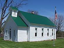
Vandalia, Indiana
Vandalia is an unincorporated community in Lafayette Township, Owen County, in the U.S. state of Indiana.[2]
Vandalia, Indiana | |
|---|---|
 Vandalia, Indiana Historic Chapel & School | |
 Vandalia  Vandalia | |
| Coordinates: 39°18′45″N 86°51′58″W | |
| Country | United States |
| State | Indiana |
| County | Owen |
| Township | Lafayette |
| Elevation | 787 ft (240 m) |
| Time zone | UTC-5 (Eastern (EST)) |
| • Summer (DST) | UTC-4 (EDT) |
| ZIP code | 47868 |
| Area code(s) | 812, 930 |
| GNIS feature ID | 445224 |
History
Vandalia was laid out in 1839.[3] A post office was established at Vandalia in 1846, and remained in operation until it was discontinued in 1927.[4] Two remaining landmarks and reminders of Vandalia's past are the historic chapel (built in 1895) and one-room schoolhouse (building completed in 1868), preserved and maintained by the Vandalia Community Preservation Association.[5]


Geography
Vandalia is located at 39°18′45″N 86°51′58″W at an elevation of 787 feet. It lies at the east end of State Road 246 where it intersects State Road 46. The main village originated nearer coordinates 39.3137257,-86.8679851 [6] where (in 2017) the historic chapel and one-room schoolhouse continue to exist through the preservation efforts of the Vandalia Community Preservation Association.
References
- "US Board on Geographic Names". United States Geological Survey. October 25, 2007. Retrieved 2017-05-01.
- "Vandalia, Indiana". Geographic Names Information System. United States Geological Survey. Retrieved July 19, 2017.
- Blanchard, Charles (1884). Counties of Clay and Owen, Indiana: Historical and Biographical. F.A. Battey & Company. pp. 820.
- "Owen County". Jim Forte Postal History. Retrieved 21 September 2015.
- "Vandalia Community Preservation Association". Organization Founded 1995.
- "Google Maps". Location where the main village of Vandalia, Indiana originated.