Jennings Township, Owen County, Indiana
Jennings Township is one of thirteen townships in Owen County, Indiana, United States. As of the 2010 census, its population was 846 and it contained 405 housing units.[1]
Jennings Township | |
|---|---|
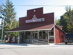
 General store in Cataract, within the township | |
 Location in Owen County | |
| Coordinates: 39°26′02″N 86°48′54″W | |
| Country | |
| State | |
| County | Owen |
| Government | |
| • Type | Indiana township |
| Area | |
| • Total | 20.06 sq mi (52.0 km2) |
| • Land | 19.59 sq mi (50.7 km2) |
| • Water | 0.47 sq mi (1.2 km2) 2.34% |
| Elevation | 751 ft (229 m) |
| Population (2010) | |
| • Total | 846 |
| • Density | 43.2/sq mi (16.7/km2) |
| ZIP codes | 46120, 47460, 47868 |
| GNIS feature ID | 453508 |
History
Jennings Township was organized in 1842. It was named for T. C. Jennings, who played an active role in its establishment.[2]
The Cataract Falls Covered Bridge was listed on the National Register of Historic Places in 2005.[3]
Geography
According to the 2010 census, the township has a total area of 20.06 square miles (52.0 km2), of which 19.59 square miles (50.7 km2) (or 97.66%) is land and 0.47 square miles (1.2 km2) (or 2.34%) is water.[1]
Unincorporated towns
(This list is based on USGS data and may include former settlements.)
Cemeteries
The township contains Maze Cemetery.
Lakes
- Paradise Lake
School districts
- Cloverdale Community Schools
Political districts
- State House District 46
- State Senate District 37
gollark: All aeons, in theory.
gollark: I wonder whether some sort of modified external trade hub with more freedom to offer on multiple things would work better.
gollark: I've decided that it is probably impossible without days of waiting.
gollark: Mine is from the cave. They turn up quite a lot, I think.
gollark: I don't know, I'm reposting the trade with a stunned hatchling.
References
- "Jennings Township, Owen County, Indiana". Geographic Names Information System. United States Geological Survey. Retrieved 2009-10-23.
- United States Census Bureau 2009 TIGER/Line Shapefiles
- IndianaMap
- "Population, Housing Units, Area, and Density: 2010 - County -- County Subdivision and Place -- 2010 Census Summary File 1". United States Census. Archived from the original on 2020-02-12. Retrieved 2013-05-10.
- Blanchard, Charles (1884). Counties of Clay and Owen, Indiana: Historical and Biographical. F.A. Battey & Company. pp. 806.
- "National Register Information System". National Register of Historic Places. National Park Service. July 9, 2010.
External links
This article is issued from Wikipedia. The text is licensed under Creative Commons - Attribution - Sharealike. Additional terms may apply for the media files.