Harrison Township, Owen County, Indiana
Harrison Township is one of thirteen townships in Owen County, Indiana, United States. As of the 2010 census, its population was 444 and it contained 208 housing units.[1]
Harrison Township | |
|---|---|
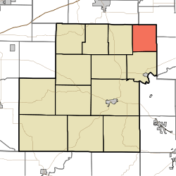 Location in Owen County | |
| Coordinates: 39°26′19″N 86°40′17″W | |
| Country | |
| State | |
| County | Owen |
| Government | |
| • Type | Indiana township |
| Area | |
| • Total | 17.58 sq mi (45.5 km2) |
| • Land | 17.55 sq mi (45.5 km2) |
| • Water | 0.03 sq mi (0.08 km2) 0.17% |
| Elevation | 787 ft (240 m) |
| Population (2010) | |
| • Total | 444 |
| • Density | 25.3/sq mi (9.8/km2) |
| ZIP codes | 46166, 47433, 47456 |
| GNIS feature ID | 453394 |
History
Harrison Township was organized in 1837.[2]
Geography
According to the 2010 census, the township has a total area of 17.58 square miles (45.5 km2), of which 17.55 square miles (45.5 km2) (or 99.83%) is land and 0.03 square miles (0.078 km2) (or 0.17%) is water.[1]
Unincorporated towns
Cemeteries
The township contains Asher Cemetery.
Airports and landing strips
- Shenandoah Flying Field Airport
School districts
- Spencer-Owen Community Schools
Political districts
- State House District 47
- State Senate District 37
gollark: We just think they're a good idea. There's nothing encoded in the universe which says "yes here you go, this is Good™ and this is Bad™".
gollark: Nope!
gollark: Human rights are totally subjective.
gollark: As a foolish human, you are not objective, and you're not immune to the is/ought problem.
gollark: > See, this is part of why I dislike your administration.Because I'm multiplexing a bunch of conversations here, I was responding to this:> that was just a statement of obvjective fact.
References
- "Harrison Township, Owen County, Indiana". Geographic Names Information System. United States Geological Survey. Retrieved 2009-10-23.
- United States Census Bureau 2009 TIGER/Line Shapefiles
- IndianaMap
- "Population, Housing Units, Area, and Density: 2010 - County -- County Subdivision and Place -- 2010 Census Summary File 1". United States Census. Archived from the original on 2020-02-12. Retrieved 2013-05-10.
- Blanchard, Charles (1884). Counties of Clay and Owen, Indiana: Historical and Biographical. F.A. Battey & Company. pp. 812.
External links
- Indiana Township Association
- United Township Association of Indiana
- City-Data.com page for Harrison Township
Places adjacent to Harrison Township, Owen County, Indiana | |
|---|---|
Municipalities and communities of Owen County, Indiana, United States | ||
|---|---|---|
| Towns | Map of Indiana highlighting Owen County | |
| Townships | ||
| Unincorporated communities |
| |
| Ghost town | ||
| Footnotes | ‡This populated place also has portions in an adjacent county or counties | |
This article is issued from Wikipedia. The text is licensed under Creative Commons - Attribution - Sharealike. Additional terms may apply for the media files.