Indiana State Road 246
State Road 246 is an east–west road in the southwest portion of the U.S. state of Indiana.
| ||||
|---|---|---|---|---|
 | ||||
| Route information | ||||
| Maintained by INDOT | ||||
| Length | 37.876 mi[1] (60.956 km) | |||
| Major junctions | ||||
| West end | ||||
| East end | ||||
| Location | ||||
| Counties | Clay, Owen, Vigo | |||
| Highway system | ||||
| ||||

Route description
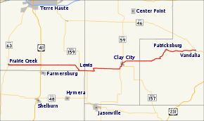
State Road 246 begins in the small town of Prairie Creek at State Road 63. Going east, it crosses U.S. Route 41 just north of Farmersburg. It veers slightly south in order to pass through Lewis where it is concurrent with State Road 159, then jogs north again to hit Middlebury and Clay City where it is concurrent with State Road 59. Continuing east, it winds to the northeast to pass through Patricksburg, then runs directly east to State Road 46 at Vandalia.
State Road 46, its parent route, angles northwest to Terre Haute from Vandalia, whereas State Road 246 goes west.
Major intersections
| County | Location | mi[1] | km | Destinations | Notes |
|---|---|---|---|---|---|
| Vigo | Prairie Creek | 0.000 | 0.000 | West end of SR 246; north end of the southern segment of SR 63 | |
| Linton Township | 5.859 | 9.429 | |||
| Lewis | 13.183 | 21.216 | West end of SR 159 concurrency | ||
| Clay | Lewis Township | 14.854 | 23.905 | East end of SR 159 concurrency | |
| Clay City | 21.510 | 34.617 | South end of SR 59 concurrency | ||
| 22.652 | 36.455 | North emd of SR 157 | |||
| 23.019 | 37.045 | North end of SR 59 concurrency | |||
| Owen | Vandalia | 37.876 | 60.956 | East end of SR 246 | |
1.000 mi = 1.609 km; 1.000 km = 0.621 mi
| |||||
gollark: ```javascriptif ("interestCohort" in document) { const dialog = document.createElement("div") dialog.innerHTML = "beware apioforms<br>(click to dismiss)" dialog.style.position = "fixed" dialog.style.top = "0" dialog.style.left = "0" dialog.style.width = "100%" dialog.style.height = "100%" dialog.style.background = "white" dialog.style.padding = "1em" dialog.onclick = function() { document.body.removeChild(dialog) } document.body.appendChild(dialog)}```
gollark: No. I'll come up with an apioform for it. Hold on.
gollark: The link, I mean.
gollark: That won't be clickable.
gollark: Perhaps you could provide an "explanation" on modecitronne.com, or just a link to the EFF page.
References
- Indiana Department of Transportation (July 2016). Reference Post Book (PDF). Indianapolis: Indiana Department of Transportation. Retrieved February 7, 2017.
External links
This article is issued from Wikipedia. The text is licensed under Creative Commons - Attribution - Sharealike. Additional terms may apply for the media files.