U.S. Route 383
U.S. Route 383 was a north–south United States highway. US 383 was created in 1942, and deleted in 1982. After deletion, a portion of the highway became K-383.
| |
|---|---|

US 383 highlighted in red | |
| Route information | |
| Auxiliary route of US 83 | |
| Existed | 1942–1982 |
| Major junctions | |
| South end | |
| North end | |
| Highway system | |
Route description
Kansas
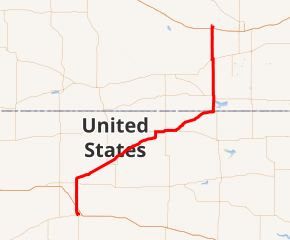
US-383 began in Oakley, heading north along present-day US-83. A short distance north of Oakley, the route intersected I-70. In Halford, US-83/US-383 crossed over US-24. From here, the road turned northeast, where US-383 split from US-83 near Leoville. US-383 continued to the northeast until meeting US-36. At this point, the route turned east for a concurrency with US-36, crossing US-283 in Norton. Past Norton, US-383 split from US-36 and resumed northeast, reaching an intersection with US-183 near Woodruff a short distance south of the Nebraska border.[1][2]
History
When the route was first commissioned in 1942, it ran from Oakley, Kansas to Elm Creek, Nebraska, a distance of 175 miles (282 km). In 1964, the north end of US 383 was truncated to Alma, Nebraska.
Major intersections
| State | County | Location | mi[4][5] | km | Destinations | Notes |
|---|---|---|---|---|---|---|
| Kansas | Logan | Oakley | 0 | 0.0 | Southern end of US 83 overlap | |
| Thomas | | 20 | 32 | |||
| Sheridan | | 44 | 71 | Northern end of US 83 overlap | ||
| Decatur | Dresden | 53 | 85 | |||
| Norton | | 90 | 140 | Southern end of US 36 overlap | ||
| Norton | 96 | 154 | ||||
| | 99 | 159 | ||||
| Calvert | 102 | 164 | Northern end of US 36 overlap | |||
| | 107 | 172 | ||||
| Phillips | | 138 | 222 | Southern end of US 183 overlap | ||
| 139 0 | 224 0.0 | Kansas–Nebraska state line | ||||
| Nebraska | Harlan | | 4 | 6.4 | ||
| Alma | 7 | 11 | Southern end of US 136 overlap; former N-3 east; northern end of the route after 1964 | |||
| 9 | 14 | Northern end of US 136 overlap; former N-3 west | ||||
| | 14 | 23 | ||||
| | 21 | 34 | ||||
| Phelps | Holdrege | 31 | 50 | Southern end of US 6/US 34 overlap | ||
| 32 | 51 | Northern end of US 6/US 34 overlap | ||||
| Buffalo | Elm Creek | 51 | 82 | Original northern terminus; northern end of US 183 overlap | ||
1.000 mi = 1.609 km; 1.000 km = 0.621 mi
| ||||||
See also
Related routes
References
- United States-Canada-Mexico Road Atlas (Map). Rand McNally. 2010.
- United States featuring the Interstate Highway System (Map). Cartography by General Drafting. Esso. 1966.
- Grand Island, Nebraska 1:250,000 quadrangle (Map). United States Geological Survey. 1955. Retrieved 2010-11-11.
- Official 1956 Kansas Highway Map (PDF) (Map). State Highway Commission of Kansas. 1956. Retrieved January 20, 2017.
- State Highway System (PDF) (Map). Nebraska Department of Roads. 1955. Retrieved January 20, 2017.
