Turuberan
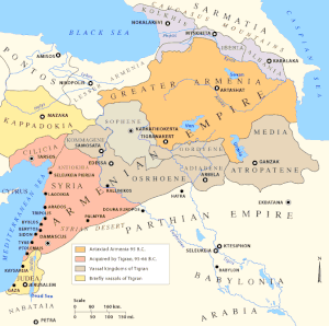
Turuberan (Armenian: Տուրուբերան) was the fourth Armenian region that was part of the ancient Kingdom of Armenia from 189 BC to 387 AD. Then it was part of the Sassanid Empire, Byzantine Empire, Arab Caliphate, medieval Kingdom of Armenia, Zakarian Armenia, various Turco-Mongol states, Safavid Empire, and finally the Ottoman Empire. A very large Armenian population remained until the Armenian Genocide in 1915. Currently it is situated in Turkey's south-east.[2][3]
| Տուրուբերան | |
|---|---|
| Province of the ancient kingdom of Armenia | |
| 189 BC–XI AD | |
 | |
| Capital | Malazgirt |
| History | |
• Artaxias I declaring himself independent | 189 BC |
• Seljuk conquests | XI AD[1] XI AD |
| Today part of | |
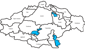
Divisions
The area of Turuberan region was 25,008 km2 (10,000 sq mi).
It had 16 cantons:
- Khouyt
- Aspakunyats Dzor
- Taron
- Ashmunik
- Mardaghi
- Dastavork
- Tvaratsatap
- Dalar
- Hark
- Varazhnunik
- Bznunik
- Yerevark
- Kajberunik or Aghiovit
- Apahunik
- Koro Gavar
- Khorkhorunik
gollark: Ugh, by the hypermemetic beeiteoids.
gollark: test.
gollark: Test.
gollark: Okay, it should have rate unlimited?
gollark: !help
See also
- List of regions of old Armenia
- Kingdom of Armenia (antiquity)
References
- hy:Տուրուբերան
- Yerevan, 1973; "Taron-Turuberan" Vol. 12, Yerevan, 1984
- hy:Տուրուբերան
Historical states and regions of Armenia | ||
|---|---|---|
| Independent Armenian states |
|  |
| Minor or dependent Armenian states |
| |
| Provinces or Ashkhars of Armenia Major | ||
| Other Armenian regions |
| |
| Other provinces under Tigranes the Great |
| |
This article is issued from Wikipedia. The text is licensed under Creative Commons - Attribution - Sharealike. Additional terms may apply for the media files.