Tropical Storm Chantal (2007)
Tropical Storm Chantal was a short-lived tropical storm in the northern Atlantic Ocean in the 2007 Atlantic hurricane season. It developed on July 31 from non-tropical origins between Bermuda and Cape Cod, and with favorable conditions, Chantal rapidly attained peak winds of 50 mph (85 km/h). The storm accelerated northeastward over an area of progressively colder water temperatures, and after a decrease in convection the National Hurricane Center ceased issuing advisories as Chantal began undergoing extratropical transition early on August 1. Shortly thereafter, the extratropical remnant crossed over southeastern Newfoundland before tracking into the open waters of the north Atlantic Ocean. Prior to forming, the storm dropped moderate rainfall on Bermuda. Subsequent to becoming extratropical, the remnants of Chantal produced gusty winds and heavy precipitation across the Avalon Peninsula of Newfoundland, causing flooding and wind damage; insured damage totaled $25 million (2007 CAD, $24.3 million 2007 USD).
| Tropical storm (SSHWS/NWS) | |
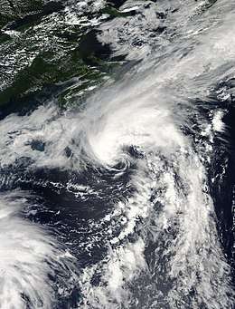
 Tropical Storm Chantal near peak intensity on July 31, 2007 | |
| Formed | July 31, 2007 |
|---|---|
| Dissipated | August 5, 2007 |
| (Extratropical after August 1, 2007) | |
| Highest winds | 1-minute sustained: 50 mph (85 km/h) |
| Lowest pressure | 994 mbar (hPa); 29.35 inHg |
| Fatalities | None reported |
| Damage | $24.3 million (2007 USD) |
| Areas affected | Bermuda, Atlantic Canada, Newfoundland |
| Part of the 2007 Atlantic hurricane season | |
Meteorological history

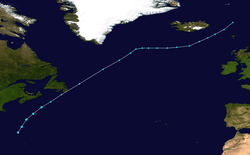
A frontal system moved off the Carolinas on July 21, and as it drifted southeastward it degenerated into a trough of low pressure; by July 26, it was nearly stationary to the east of the Bahamas. Deep convection initially failed to persist, though on July 28 meteorologists began tracking it with the Dvorak technique. The system tracked northeastward,[1] and initially unfavorable environmental conditions left the system disorganized. However, conditions were forecast to become more conducive for development,[2] and by July 29 the National Hurricane Center remarked it had "potential for tropical or subtropical development."[3] On July 30, the low passed to the west of Bermuda as it continued northeastward, under the influence of a large mid-latitude trough. The system contained an exposed low-level circulation, which intermittently passed beneath a persistent area of convection to its northeast. By early on July 31, ship reports and QuikSCAT observations suggested winds of 35 mph (55 km/h), and the center was well-involved enough with the convection for the National Hurricane Center to classify it as Tropical Depression Three while it was located about 270 miles (435 km) north-northwest of Bermuda, or about 445 miles (710 km) south-southeast of Chatham, Massachusetts.[4]
Upon receiving its classification, the depression consisted of a partially exposed low-level center with deep convection occupying the northeastern semicircle. Located over sea surface temperatures of about 80 °F (27 °C), one forecaster noted the depression had "a small window of opportunity... for it to reach tropical storm strength before transitioning to an extratropical cyclone."[5] Convection increased further over the center, and at around 0600 UTC on July 31 the depression intensified into Tropical Storm Chantal while located about 530 miles (855 km) south of Halifax, Nova Scotia. The storm continued northeastward, under the influence of a mid-level trough,[1] and Chantal quickly developed well-defined curved banding features;[6] six hours after becoming a tropical storm, Chantal reached peak winds of 50 mph (85 km/h).[1] The storm tracked through an area of progressively cold waters and cooler air,[7] resulting in the weakening of its convection. The circulation became embedded within the approaching frontal zone, and by 0600 UTC on August 1 Chantal transitioned into an extratropical cyclone.[1]
After becoming an extratropical cyclone, Chantal maintained scattered convection near its center, though its main area of convection and clouds extended to its north.[8] Midday on August 1, the cyclone struck Newfoundland along the Avalon Peninsula, hitting the Placentia Area with full force.[9] It subsequently intensified to attain winds of near hurricane-force. On August 3 the cyclone underwent a final weakening trend in the far northern Atlantic Ocean, and on August 5 the extratropical remnants of Chantal merged with another extratropical cyclone to the east of Iceland.[1]
Impact
The precursor disturbance to Chantal began affecting Bermuda on July 30, producing scattered storms and increased cloud cover. The next day the system dropped more rainfall as it passed to the west of the island, and in the two-day period precipitation accumulated to 2.12 inches (53.8 mm) at the Bermuda International Airport, accounting for 35% of the monthly rainfall total. Thunderstorms were reported on the island, and maximum reported winds on the island reached 45 mph (72 km/h).[10] After Chantal passed Bermuda, a ship with the call sign C60Y4 recorded sustained winds of 37 mph (59 km/h) over the open waters of the north Atlantic Ocean.[5] At around 2300 UTC on July 31, a buoy to the southeast of Nova Scotia reported a pressure of 995 mbar as Chantal passed nearby.[11]

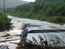
Shortly after it first became a tropical storm, the Atlantic Storm Prediction Center of Canada issued gale warnings for the coastal waters off Newfoundland.[12] Later, the Newfoundland Labrador Weather Office issued heavy rainfall warnings for southeastern Newfoundland.[13] In offshore waters, wave heights reached 20 feet (6 m). Onshore, the storm produced moderately strong winds, with an unofficial peak gust of 54 mph (88 km/h) reported near where the storm moved ashore. The extratropical remnants of Chantal dropped heavy rainfall in a short duration across Newfoundland; 1.7 inches (43 mm) fell in 1 hour at St. John's West, the highest hourly rainfall total. Across the province, precipitation peaked at 7.89 inches (200.4 mm) at Argentia. The rainfall caused flooding and street washouts in several towns along the Avalon Peninsula, such as Ship Harbour, Fox Harbour, and Dunville.[14] Several communities in the region declared states of emergencies.
In Ship Harbour citizens were isolated for 5 days until a temporary road was made. Also in Spaniard's Bay, the flooding caused a bridge to depress about 1.5 feet (50 cm);[15] a temporary bridge was built within two months, with a permanent replacement scheduled to be finished by the summer of 2008.[16] Insured damage across the area totaled $25 million (2007 CAD, $24.3 million 2007 USD).[17]
References
- Richard Pasch (2007). "Tropical Storm Chantal Tropical Cyclone Report" (PDF). National Hurricane Center. Retrieved 2007-10-18.
- Mainelli (2007). "July 29 Tropical Weather Outlook". National Hurricane Center. Retrieved 2007-07-31.
- Blake (2007). "July 29 Tropical Weather Outlook (2)". National Hurricane Center. Retrieved 2007-07-31.
- Franklin (2007). "Tropical Depression Three Discussion One". National Hurricane Center. Retrieved 2007-08-01.
- Mainelli (2007). "Tropical Depression Three Discussion Two". National Hurricane Center. Retrieved 2007-08-01.
- Blake (2007). "Tropical Storm Chantal Discussion Three". National Hurricane Center. Retrieved 2007-08-01.
- Blake (2007). "Tropical Storm Chantal Discussion Four". National Hurricane Center. Retrieved 2007-08-01.
- PJB (2007). "Post-Tropical Storm Chantal Information Statement at 3:00 AM ADT Wednesday August 1, 2007". Canadian Hurricane Centre. Archived from the original on June 11, 2011. Retrieved 2007-08-01.
- Fogarty & Roussel (2007). "Post-Tropical Storm Chantal Intermediate Information Statement at 12:30 PM ADT Wednesday August 1, 2007". Canadian Hurricane Centre. Archived from the original on June 11, 2011. Retrieved 2007-08-01.
- Bermuda Weather Service (2007). "Sunny beginning, wet ending..." Archived from the original on August 8, 2007. Retrieved 2007-08-01.
- Brown (2007). "Tropical Storm Chantal Discussion Five". National Hurricane Center. Retrieved 2007-08-01.
- PJB (2007). "Tropical Storm Chantal Information Statement at 9:00 AM ADT Tuesday July 31, 2007". Canadian Hurricane Centre. Archived from the original on June 11, 2011. Retrieved 2007-08-01.
- PJB (2007). "Tropical Storm Chantal Information Statement at 3:30 PM ADT Tuesday July 31, 2007". Canadian Hurricane Centre. Archived from the original on 2007-08-01. Retrieved 2007-08-01.
- Fogarty (2007). "Post-Tropical Storm Chantal Intermediate Information Statement at 6:30 PM ADT Wednesday August 1, 2007". Canadian Hurricane Centre. Archived from the original on June 11, 2011. Retrieved 2007-08-01.
- Ken Meaney (2007). "Newfoundlanders mopping up after Chantal". CanWest News Service. Archived from the original on 2007-09-29. Retrieved 2007-08-02.
- Lillian Simmons (2007-08-28). "Towns bite into bridgework". The Transcontinental Compass. Retrieved 2007-09-14.
- Alison Auld (2010-09-22). "Newfoundland begins cleanup of hurricane Igor's path of destruction". Medicine Hat News. Retrieved 2010-09-22.
External links
| Wikimedia Commons has media related to Tropical Storm Chantal (2007). |
