Tropical Depression Nine (2003)
Tropical Depression Nine was a weak tropical depression that developed and dissipated in the eastern Caribbean Sea in August 2003. It formed from a tropical wave on August 21 to the south of Puerto Rico, and was initially forecast to strengthen to tropical storm status, due to the favorable conditions for development in the area. However, wind shear developed over the system, and the depression degenerated to a tropical wave on August 22. The system produced moderate to heavy rainfall throughout its path. In Puerto Rico, the rains flooded ten houses, while in the Dominican Republic the precipitation led to overflown rivers and two injuries.
| Tropical depression (SSHWS/NWS) | |
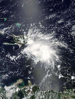
 Tropical Depression Nine in the Caribbean Sea on August 22 | |
| Formed | August 21, 2003 |
|---|---|
| Dissipated | August 22, 2003 |
| Highest winds | 1-minute sustained: 35 mph (55 km/h) |
| Lowest pressure | 1007 mbar (hPa); 29.74 inHg |
| Fatalities | None reported |
| Damage | $20,000 (2003 USD) |
| Areas affected | Lesser Antilles, Puerto Rico, Dominican Republic |
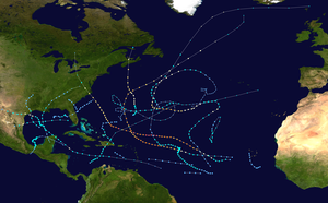
| Part of the 2003 Atlantic hurricane season | |
Meteorological history

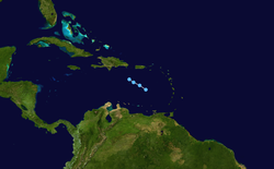
A strong tropical wave exited the coast of Africa on August 14,[1] moved westward as a disorganized system, and passed through the Cape Verde islands on August 15.[2] On August 17, a weak area of low pressure developed in the system about 750 miles (1,200 km) west-southwest of the Cape Verde islands.[3] Convection increased over the western portion of the wave axis,[4] and the system began to become better organized on August 18 while located about 1,250 miles (2,000 km) east of the Lesser Antilles.[5] However, convection around the system diminished on August 19,[6] and later that day it began to move through the Lesser Antilles. Despite favorable upper-level winds and falling atmospheric pressures, there were initially no signs of a circulation at the surface.[7] Convection again increased early on August 20,[8] and it gradually became better organized.[9] Based on a ship's wind report of the system, it is estimated the wave developed into Tropical Depression Nine on August 21 while located about 260 miles (415 km) south of San Juan, Puerto Rico.[10]
The depression quickly showed signs of organization with the development of banding features around its blossoming convection. Due to a favorable upper level environment, forecasters predicted the depression to intensify to a 70 mph (110 km/h) tropical storm after making landfall on Haiti and eastern Cuba.[10] Upper-level outflow remained well-defined, though convection waned near the center early on August 22.[11] The depression appeared to continue organizing, with a well-defined cloud band to its north and east.[12] However, strong southwesterly wind shear unexpectedly increased over the system, and the depression degenerated into a tropical wave late on August 22, south of the eastern tip of the Dominican Republic.[1] The system retained a well-defined cloud pattern with a vigorous mid-level circulation, and forecasters at the National Hurricane Center indicated regeneration could have occurred at any time.[13] The wave axis moved over the Dominican Republic early on August 23,[14] and became disorganized over the mountainous terrain of Hispaniola.[15] There existed the potential for redevelopment as it moved into a potentially more favorable area,[16] though the National Hurricane Center ceased monitoring the system on August 25 when redevelopment appeared unlikely.[17]
Preparations
Coinciding with the issuance of the first advisory on the tropical depression, the government of the Dominican Republic issued a tropical storm watch from Barahona to its border with Haiti, while a tropical storm watch was issued from Haiti's border with the Dominican Republic westward to Port-au-Prince. The United States' National Hurricane Center in Miami recommended interests in eastern Cuba to monitor the progress of the storm.[18] When the depression was 205 miles (330 km) south-southeast of Santo Domingo, the Dominican Republic issued a tropical storm warning from Punta Palenque to its border with Haiti.[19] While located 155 miles (250 km) from the coast of Hispaniola, the government of the Dominican Republic extended the tropical storm warning eastward to Isla Saona, while the government of Haiti upgraded its watch area to a tropical storm warning along the coast. The National Hurricane Center also recommended citizens in the Bahamas to monitor the progress of the storm.[20] After the heavy rainfall began in the Dominican Republic, officials evacuated citizens of low-lying areas.[21]
Impact
Before developing into Tropical Depression Nine, the precursor tropical wave dropped moderate to heavy rainfall across the Lesser Antilles.[22] The depression caused moderate rainfall in Puerto Rico, where two to three inches (50 to 75 mm) of precipitation were recorded.[23] The flooding from the rainfall entered ten houses and left some streets impassable.[24] A mudslide was reported in the eastern portion of the island.[25] A river in northeastern Puerto Rico surpassed its banks from flooding, though it returned to normal levels within hours.[26] Damage in Puerto Rico totaled $20,000 (2003 USD, $27.8 thousand 2020 USD).[24]
The depression dropped over 1 inch (25 mm) of precipitation across much of the Dominican Republic; Santo Domingo reported a peak total of 3.9 in (98 mm). The rainfall led to flooding, primarily east and west of the capital city, while five rivers overflowed their banks. Several roads were inundated, obstructing traffic. The flooding collapsed a sports center and a house, injuring two people inside. Further inland, 160 people had to be evacuated when more than 100 houses were flooded. Crop damage was also reported. In Pedernales, gusty winds uprooted trees, several of which fell on power lines which caused power outages in the town.[27] The rainfall was welcomed in the country, as conditions were dry in the preceding months.[21] Light flooding also occurred in eastern Jamaica, though damage there, if any, is unknown.[27]
See also
- Tropical cyclone
- List of storms in the 2003 Atlantic hurricane season
- Timeline of the 2003 Atlantic hurricane season
References
- Lixion Avila (2003). "Tropical Depression Nine Tropical Cyclone Report" (PDF). National Hurricane Center. Retrieved May 22, 2015.
- Avila (2003). "August 15 Tropical Weather Outlook". NHC. Retrieved 2006-10-24.
- Pasch (2003). "August 17 Tropical Weather Outlook". NHC. Retrieved 2006-10-24.
- Pasch & Cobb (2003). "August 18 Tropical Weather Outlook". NHC. Retrieved 2006-10-24.
- Stewart (2003). "August 18 Tropical Weather Outlook". NHC. Retrieved 2006-10-24.
- Avila (2003). "August 19 Tropical Weather Outlook". NHC. Retrieved 2006-10-24.
- Pasch (2003). "August 19 Tropical Weather Outlook (2)". NHC. Retrieved 2006-10-24.
- Pasch (2003). "August 19 Tropical Weather Outlook". NHC. Retrieved 2006-10-24.
- Pasch (2003). "August 20 Tropical Weather Outlook". NHC. Retrieved 2006-10-24.
- Avila (2003). "Tropical Depression Nine Discussion One". NHC. Retrieved 2006-10-24.
- Pasch (2003). "Tropical Depression Nine Discussion Two". NHC. Retrieved 2006-10-24.
- Avila & Molleda (2003). "Tropical Depression Nine Discussion Four". NHC. Retrieved 2006-10-24.
- Avila & Molleda (2003). "Tropical Depression Nine Discussion Five". NHC. Retrieved 2006-10-24.
- Lawrence (2003). "August 22 Tropical Weather Outlook". NHC. Retrieved 2006-10-24.
- Lawrence (2003). "August 23 Tropical Weather Outlook". NHC. Retrieved 2006-10-24.
- Pasch (2003). "August 24 Tropical Weather Outlook". NHC. Retrieved 2006-10-24.
- Franklin (2003). "August 25 Tropical Weather Outlook". NHC. Retrieved 2006-10-24.
- Avila (2003). "Tropical Depression Nine Public Advisory One". NHC. Retrieved 2006-10-24.
- Beven (2003). "Tropical Depression Nine Public Advisory Three". NHC. Retrieved 2006-10-24.
- Avila (2003). "Tropical Depression Nine Public Advisory Four". NHC. Retrieved 2006-10-24.
- Stormcarib.net (2003). "Unofficial Reports from the Dominican Republic". Retrieved 2006-10-24.
- Mike Davis (2003). "Unofficial Reports from Saint Lucia". Stormcarib.com. Retrieved 2006-10-24.
- National Climatic Data Center (2003). "Event Report for Puerto Rico". Archived from the original on 2011-05-19. Retrieved 2006-10-24.
- National Climatic Data Center (2003). "Event Report for Puerto Rico (2)". Archived from the original on 2011-05-19. Retrieved 2006-10-24.
- NCDC (2003). "Event Report for Puerto Rico (3)". Archived from the original on 2011-05-19. Retrieved 2006-10-24.
- NCDC (2003). "Event Report for Puerto Rico (4)". Archived from the original on 2011-05-19. Retrieved 2006-10-24.
- World Meteorological Organization (2004). "Final Report of the 2003 Hurricane Season" (PDF). Archived from the original (PDF) on October 29, 2005. Retrieved 2006-10-24.
External links
| Wikimedia Commons has media related to Tropical Depression Nine (2003). |
