Tocorpuri
Cerros de Tocorpuri is a volcanic complex located along the border between Bolivia and Chile.
| Cerros de Tocorpuri | |
|---|---|
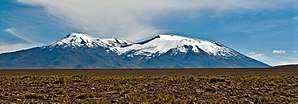 View from the south-west. | |
| Highest point | |
| Elevation | 5,808 m (19,055 ft) |
| Coordinates | 22°26′20″S 67°53′15″W |
| Geography | |
| Location | Bolivia-Chile |
| Parent range | Andes |
| Geology | |
| Mountain type | Stratovolcano |
| Last eruption | Unknown |
Volcan Tocorpuri is constructed by andesitic lava flows with some pyroclastics, which form a 1 kilometre (0.62 mi) high pile with a 1.2 kilometres (0.75 mi) wide summit crater. After this edifice was built, several vents developed on its northwestern flank and south of the summit crater. These vents produced dominantly andesitic lava flows. The southeastern flank of the main Tocorpuri volcano shows evidence of a sector collapse.[1]
On its west side lies a rhyolite lava dome called Cerro La Torta. Its steep sides are surrounded with talus and its top surface has flow structures.[1]
The complex is located at about 30 km. from the El Tatio geothermal energy field.
Volcanism along the Andes occurs in four separate belts, the Northern Volcanic Zone, the Central Volcanic Zone, the Southern Volcanic Zone and the Austral Volcanic Zone.[1] Tocorpuri is part of the Central Volcanic Zone, which in this region is characterized by an ignimbrite formation and individual volcanoes, with compositions ranging from andesite over dacite to rhyolite. Both these formations are emplaced on a Cretaceous-Miocene basement formed by sediments and volcanic rocks, which overlay Precambrian-Paleozoic layers.[1][2] Aside from stratovolcanoes which are lined up in the Western Cordillera,[1] the Altiplano-Puna volcanic complex is also a component of the Central Volcanic Zone and is formed by large calderas and lava domes such as La Torta.[3]
Of those units of Tocorpuri that have been sampled, most are andesitic with phenocrysts of amphibole, biotite, pyroxene and quartz. La Torta also has phenocrysts of sanidine and additional apatite and titanite.[1]
The main Tocorpuri volcano is partly covered by the Tatio ignimbrite, which is about 800,000 years old.[1] The Torta lava dome was erupted within the last 100,000 years.[3] The Tocorpuri complex has been affected by glaciation during the Pleistocene.[1]
The area north of La Torta is also the site of a hydrothermal system at an elevation of 5,000 metres (16,000 ft)[4] which emit calcium sulfate rich water.[2] These hot springs and associated gases are principally low temperature atmospheric systems,[5] with the average temperature not exceeding 28 °C (82 °F) and a high proportion of atmospheric gases. Presumably, ascending hydrothermal fluids interact with a thick precipitation-fed aquifer before emerging.[2]
See also
References
- De Astis, G.; Lucchi, F.; Tranne, C. A.; Rossi, P. L. (December 2009). "Evidence for different processes of magma evolution in El Tatio volcanic region (22°16' to 22°30' S, Central Volcanic Zones, Andes)" (PDF). OA Earth-prints Repository. GeoActa special publication 2. Retrieved 11 December 2017.
- Tassi, F.; Aguilera, F.; Darrah, T.; Vaselli, O.; Capaccioni, B.; Poreda, R.; Medina, E. (November 2009). "Geochemical survey of geothermal systems in northern Chile" (PDF). SERNAGEOMIN. Santiago: 12th Chilean Geological Congress. pp. 1–4. Retrieved 11 December 2017.
- Mercado, J.L.; Ahumada, S.; Aguilera, F.; Medina, E.; Renzulli, A.; Piscaglia, F. (November 2009). "Geological and Structural Evolution of Apacheta-Aguilucho Volcanic Complex (AAV C), Northern Chile" (PDF). SERNAGEOMIN. Santiago: 12th Chilean Geological Congress. pp. 1–4. Retrieved 11 December 2017.
- Tassi, F.; Aguilera, F.; Darrah, T.; Vaselli, O.; Capaccioni, B.; Poreda, R.J.; Delgado Huertas, A. (April 2010). "Fluid geochemistry of hydrothermal systems in the Arica-Parinacota, Tarapacá and Antofagasta regions (northern Chile)". Journal of Volcanology and Geothermal Research. 192 (1–2): 1–15. doi:10.1016/j.jvolgeores.2010.02.006. ISSN 0377-0273.
- Tassi, Franco; Aguilera, Felipe; Vaselli, Orlando; Medina, Eduardo (January 2008). A geochemical survey of geothermal resources in the Tarapacá and Antofagasta regions (northern Chile) (DOC) – via ResearchGate.
Bibliography
- González-Ferrán, Oscar (1995). Volcanes de Chile. Santiago, Chile: Instituto Geográfico Militar. p. 640 pp. ISBN 956-202-054-1.(Spanish)
- "Tocorpuri". Global Volcanism Program. Smithsonian Institution.
External links
| Wikimedia Commons has media related to Tocorpuri. |