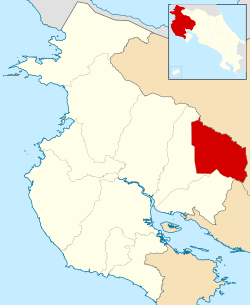
Tilarán (canton)
Tilarán is the eighth canton in the province of Guanacaste in Costa Rica. The canton covers an area of 638.39 km²,[1] and has a population of 20,708.[2] Its capital city is also called Tilarán.
Tilarán | |
|---|---|
Cantón | |
 Location of Tilarán Canton in Guanacaste Province | |
| Country | Costa Rica |
| Province | Guanacaste |
| Area | |
| • Total | 638.39 km2 (246.48 sq mi) |
| Population (June 2013) | |
| • Total | 20,708 |
| • Density | 32/km2 (84/sq mi) |
The canton surrounds Lake Arenal (Laguna de Arenal) except for the lake's southeast end, which belongs to the province of Alajuela. The northern border is in the Cordillera de Guanacaste, touching the Río Corobicí at its northernmost limits. The south part of the canton is in the Cordillera de Tilarán.
Districts
The canton of Tilarán is subdivided into seven districts (distritos):[3]
| District | Postal code | Alt. (m) | Area (km2) | Pop. (2013) | Coordinates | Capital |
|---|---|---|---|---|---|---|
| Tilarán | 50801 | 564 | 138.78 | 8,892 | 10°28′18″N 84°58′09″W | |
| Barrios: Cabra, Carmen, Juan XXIII, Lomalinda | ||||||
| Poblados: Cuatro Esquinas, Chiripa, Piamonte, Río Chiquito, San Luis, Tejona, Tres Esquinas | ||||||
| Quebrada Grande | 50802 | 725 | 76.02 | 2,893 | 10°25′57″N 84°56′51″W | |
| Poblados: Barrionuevo, Cabeceras de Cañas, Campos de Oro, Dos de Tilarán, Esperanza, Florida, Monte Olivos, Nubes, San Miguel, Turín (part), Vueltas | ||||||
| Tronadora (Nuevo Tronadora) |
50803 | 600 | 122.27 | 1,913 | 10°30′12″N 84°55′30″W | |
| Poblados: Arenal Viejo, Colonia Menonita, Río Chiquito Abajo, Silencio | ||||||
| Santa Rosa | 50804 | 432 | 71.11 | 2,048 | 10°29′30″N 85°01′20″W | Ángeles |
| Poblados: Aguilares, Campos Azules, Montes de Oro (part), Naranjos Agrios, Palma, Quebrada Azul, Ranchitos, Santa Rosa | ||||||
| Líbano | 50805 | 280 | 71.23 | 927 | 10°25′05″N 84°59′14″W | |
| Poblados: Alto Cartago, Maravilla, San José, Solania | ||||||
| Tierras Morenas | 50806 | 685 | 83.46 | 1,467 | 10°34′21″N 85°01′40″W | |
| Poblados: Aguacate, Aguas Gatas (part), Bajo Paires, Guadalajara, Montes de Oro (part), Paraíso (part), Río Piedras, Sabalito | ||||||
| Arenal (Nuevo Arenal) |
50807 | 620 | 75.52 | 2,568 | 10°32′49″N 84°53′58″W | |
| Poblados: Mata de Caña, Sangregado, San Antonio, Unión | ||||||
History
The canton was established by law on August 21, 1923.
gollark: I have heard about that in startups and stuff. It's worrying.
gollark: One somewhat convincing theory about that is that they just signal that you have some baseline level of sanity, conformity, ability to stick to things for a few years, etc.
gollark: *Hopefully* degrees and stuff are about somewhat more than just status?
gollark: Although if they're worse, it might be damaging.
gollark: I mean, theoretically you still have more total engineers available, which is a good thing, even if individuals might get less pay.
References
- Instituto Geográfico Nacional (IGN), 2001.
- Estadísticas Vitales 2013 Archived 2015-04-02 at the Wayback Machine - INEC
- "División Territorial Administrativa de Costa Rica" (PDF) (in Spanish). Instituto de Fomento y Asesoria Municipal (IFAM). 5 May 2009. Archived from the original (PDF) on 2 August 2015.
Principal places of Tilarán Historia Y Cultura De tilarán Business listing platform for Tilarán area
This article is issued from Wikipedia. The text is licensed under Creative Commons - Attribution - Sharealike. Additional terms may apply for the media files.