Thung Salaeng Luang National Park
Thung Salaeng Luang National Park (Thai: อุทยานแห่งชาติทุ่งแสลงหลวง) is a 1,262 km2 national park in Phitsanulok and Phetchabun Provinces of Thailand. It encompasses substantial portions of Wang Thong and Lom Sak Districts.[1]
| Thung Salaeng Luang National Park | |
|---|---|
IUCN category II (national park) | |
 | |
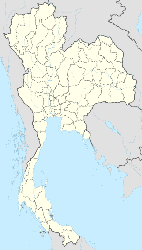 Location within Thailand | |
| Location | Phitsanulok and Phetchabun Provinces, Thailand |
| Coordinates | 16°49′40″N 100°52′12″E |
| Area | 1,262 km2 |
| Established | 1963 |
| Visitors | 147,997[1] (in 2015) |
| Governing body | Department of National Parks, Wildlife and Plant Conservation |
Topography
The park consists of limestone hills, slate and hardpan at altitudes ranging from 300 to 1,028 meters.[2] Thung Salaeng Luang is inlaid with meadows, especially in the southern portions of the park.[2] The park is the source of numerous streams.[2] There are large salt licks at Pong Sai in the northwest and Pong Thung Phaya in the southwest.[2] The Wang Thong River flows through the park.
Flora
Deciduous dipterocarp and mixed evergreen-deciduous forest with lowland shrub, such as Mussaenda parva and broadleaved evergreen, such as Livistona palm and Phoenix Loureiri palm. [3]:106 Plants include Barleria strigosa, Ardisia crenata and Pseuderanthemum andersonii.[3]:108
Fauna
Large mammals include Asian elephant, Gaur, barking deer and Sambar deer.[3]:107 Small mammals include Yellow-throated marten, Masked palm civet, white handed gibbon, Crab-eating macaque, Slow loris, Black giant squirrel and Burmese hare.[3]:109 This national park is famous for its butterflies, such as Common archduke.[3]:104
Birds include.[3]:105
further not specified.
Climate
The average annual temperature is 25 °C, although temperatures often reach 30 °C during late spring and early summer.[2] The average annual rainfall is 1.7 meters.[2]
History
Thung Salaeng Luang was proposed for inclusion in the national parks system In 1959. Thung Salaeng Luang was declared a national park in 1972.[2] From the late-1960s to the early-1980s, the park's forest was used as a base for guerrillas of the Communist Party of Thailand.[2]
Places
- Thung Salaeng: Park meadows.
- Thung Nang Phaya: A grassy area of the park known for its combination of meadow and pine trees.[2]
- Thung Non Son: A meadow area near the center of the park on a plateau. In the fall, Thung Non Son is resplendent with large clusters of flowers.[2]
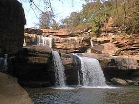
- Kaeng Song Waterfall, (or Namtok Kaeng Sopha): A three-tiered waterfall of the Wang Thong River.[2] Shaped like a stairway, Kaeng Sopha is the largest waterfall in Phitsanulok, and it has been dubbed the Niagara Falls of Thailand. The torrents are very strong in the rainy season. The vapor rising in the area creates a vast rain-like curtain. Kaeng Sopha is the subject of a June 2007 postage stamp in the Thailand Waterfall series.
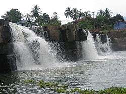 Poi waterfall
 - Caves: The park has several caves including Wang Daeng and Dao Duan.
- Kaeng Wang Nam Yen Rapids are in the park.
Effects of human presence
Communist insurgents as well as hill tribes and other intruders have destroyed some of the park's flora and fauna over the years.[2]
Facilities
There are seven bungalows at the park's headquarters and five bungalows at Nong Mae Na office.[2] There are also four campsites at the park.[2] There are no concessions in the park.
References
- "Thung Salaeng Luang National Park". Department of National Parks (Thailand). Archived from the original on 26 March 2016. Retrieved 24 March 2016.
- National parks in northern Thailand
- Elliot, Stephan; Cubitt, Gerald (2001). THE NATIONAL PARKS and other Wild Places of THAILAND. New Holland Publishers (UK) Ltd. ISBN 9781859748862.
External links
| Wikimedia Commons has media related to Thung Salaeng Luang National Park. |
| Authority control |
|
|---|