Wang Thong District
Wang Thong (Thai: วังทอง, pronounced [wāŋ tʰɔ̄ːŋ]) is a district (amphoe) of Phitsanulok Province, central Thailand.
Wang Thong วังทอง | |
|---|---|
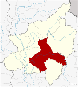 District location in Phitsanulok Province | |
| Coordinates: 16°49′27″N 100°25′43″E | |
| Country | Thailand |
| Province | Phitsanulok |
| Seat | Wang Thong |
| Area | |
| • Total | 1,687.05 km2 (651.37 sq mi) |
| Population (2009) | |
| • Total | 119,103 |
| • Density | 71.5/km2 (185/sq mi) |
| Time zone | UTC+7 (ICT) |
| Postal code | 65130 |
| Geocode | 6508 |
History
Wang Thong was established in 1895 as Nakhon Pa Mak District, named after the central tambon, the district office being located in Ban Sam Ruen. However, the original location was difficult to reach and also flooded every year, and the district office was moved to the east side of the Wang Thong River, where the Wang Thong Municipal Market now stands.
In 1928 the government created Bang Krathum District, and tambons Phai Lom, Noen Kum, and Nakhon Pa Mak were assigned to it.[1] Tambons Kaeng Sopha and Ban Klang of Nakhon Thai District were reassigned to Wang Thong.
When the buildings on the east bank of Wang Thong River were washed away by a flood, the district office relocated to its present site. In 1931 the district name was changed to Pa Mak, finally designated as Wang Thong in 1939.[2]
Geography
Neighboring districts are (from the south clockwise), Sak Lek of Phichit Province, Bang Krathum, Mueang Phitsanulok, Wat Bot, Chat Trakan, Nakhon Thai of Phitsanulok Province, Khao Kho of Phetchabun Province and Noen Maprang of Phitsanulok Province.
Rivers
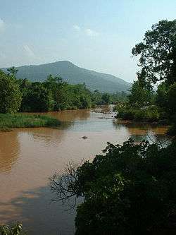
Wang Thong lies within the Nan Basin, which is part of the Chao Phraya Watershed. The important water resource is Wang Thong River (Khek River). The Khwae Noi River and Tha Muen Ram River also flow through this district.
Swamps
The Bueng Rachanok Swamp is a popular tourist destination in the district.
Administration
The district is divided into 11 sub-districts (tambons), which are further subdivided into 166 villages (mubans). Wang Thong is sub-district municipality (thesaban tambon) which covers part of the same-named tambon. There are a further 11 tambon administrative organizations (TAO).
| No. | Name | Thai | Villages | Pop.[3] |
|---|---|---|---|---|
| 1. | Wang Thong | วังทอง | 15 | 19,808 |
| 2. | Phan Chali | พันชาลี | 17 | 9,592 |
| 3. | Mae Raka | แม่ระกา | 15 | 7,156 |
| 4. | Ban Klang | บ้านกลาง | 27 | 19,733 |
| 5. | Wang Phikun | วังพิกุล | 15 | 8,259 |
| 6. | Kaeng Sopha | แก่งโสภา | 13 | 10,912 |
| 7. | Tha Muen Ram | ท่าหมื่นราม | 14 | 8,071 |
| 8. | Wang Nok Aen | วังนกแอ่น | 20 | 16,119 |
| 9. | Nong Phra | หนองพระ | 12 | 6,994 |
| 10. | Chaiyanam | ชัยนาม | 9 | 6,088 |
| 11. | Din Thong | ดินทอง | 11 | 6,371 |
Infrastructure
Significant Settlements
The following settlements of the Wang Thong District are significant enough in size as to occupy multiple mubans:
- Town of Ban Wang Thong
- Ban Gok Mai Daeng
- Ban Din Thong
- Ban Sadao
- Ban Phan Chali
- Ban Supraron Phanom Thong
- Ban Nam Rin
- Ban Mae Raka
- Ban Kao Noi
- Ban Kaeng Gula
- Ban Kao Hom
- Ban Dong Phluang
Radio
- There is one radio station broadcast from Wang Thong, the Sathaanii Witthayu Ratthasaphaa (Parliament Radio Station). The frequency is 92.25 FM.[4]
Attractions
Flooding
Wang Thong was hit by severe flooding in 2007. By 8 October 2007, flooding in the Wang Thong District had killed at least three people, and the district was declared a disaster zone.[5]
References
- แจ้งความกระทรวงมหาดไทย เรื่อง ตั้งกิ่งอำเภอบางกระทุ่ม จังหวัดพิษณุโลก (PDF). Royal Gazette (in Thai). 44 (0 ง): 1231. 1927-07-17.
- พระราชกฤษฎีกาเปลี่ยนนามอำเภอ กิ่งอำเภอ และตำบลบางแห่ง พุทธศักราช ๒๔๘๒ (PDF). Royal Gazette (in Thai). 56 (0 ก): 354–364. April 17, 1939.
- "Population statistics 2009". Department of Provincial Administration. Archived from the original on 2016-03-04. Retrieved 2010-07-14.
- Radio Stations in Phitsanulok Province, Thailand
- "Three dead in Phitsanulok floods". Archived from the original on 2007-12-24. Retrieved 2007-10-15.